Category:US National Archives series: Master Plans of Parks and Monuments, 1931 - 1941
Jump to navigation
Jump to search
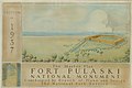
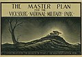
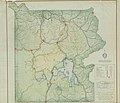
This series consists of topographic maps, road system maps, trail plans, developed and special area plans, fire-control maps, vegetation maps and administrative and utility area plans. Ornamental covers, on which appear original pen-and-ink, crayon, wash, or watercolor drawings adorn most of the individual park plan sets. Periodic revisions may also be included.
Media in category "US National Archives series: Master Plans of Parks and Monuments, 1931 - 1941"
The following 19 files are in this category, out of 19 total.
-
 Base Map - NARA - 84786372.jpg 6,720 × 8,314; 6.15 MB
-
 Bright Angel Point Area -- North Rim - NARA - 84786376.jpg 11,371 × 6,496; 14.87 MB
-
 Cover of 1938 Master Plan - DPLA - 23249eb7f4c24d6ba8555fcd1dd42150.jpg 13,129 × 10,624; 14.98 MB
-
 Cover of Master Plan - NARA - 84786368.jpg 12,674 × 9,671; 5.05 MB
-
 Cover of Master Plan - NARA - 84786374.jpg 13,466 × 8,928; 13.96 MB
-
 Cover of Master Plan - NARA - 84786378.jpg 11,383 × 6,432; 7.79 MB
-
 Cover of Master Plan - NARA - 84786382.jpg 12,178 × 7,676; 6.8 MB
-
 Cover of Master Plan - NARA - 84786386.jpg 13,043 × 9,056; 17.43 MB
-
 Cover of Master Plan - NARA - 84786390.jpg 1,000 × 672; 111 KB
-
 Cover of Master Plan - NARA - 84786392.jpg 12,599 × 10,656; 19.18 MB
-
 Fire Control Map - NARA - 84786394.jpg 12,519 × 10,784; 10.64 MB
-
 Headquarters & Park Village - NARA - 84786370.jpg 11,059 × 6,976; 6.12 MB
-
 Map of Picnic Grounds - NARA - 84786388.jpg 13,206 × 8,992; 13.43 MB
-
 Old Faithful Auto Parking No. 1 & 2 - DPLA - b586c4eeab0af1a2b19be3b69eda29cc.jpg 12,581 × 10,688; 16.43 MB
-
 Roads & Trails Map - DPLA - d9ad67410ea106fa82d54a1f17edae84.jpg 11,557 × 9,088; 13.59 MB
-
 Roads, Trails, and Developed Areas - DPLA - 1da16fabf8be7ea4ad153c3dfa6a41d4.jpg 12,064 × 7,744; 8.59 MB
-
 South Rim Village -- Operators Area - DPLA - d15458ffd48607e6d2462169dd65dc23.jpg 11,378 × 6,528; 14.46 MB
-
 The Master Plan Dinosaur National Monument - DPLA - ab3848d079a2e0ec3c33a683a6af0cc3.jpg 11,817 × 7,232; 11.51 MB
-
 Tower Falls Parking Area Plan - DPLA - a88b0be2760e139aad3de6a784a20a2e.JPG 12,444 × 10,720; 14.92 MB


