Category:Unidentified maps of the United States
Jump to navigation
Jump to search
Media in category "Unidentified maps of the United States"
The following 200 files are in this category, out of 348 total.
(previous page) (next page)-

-

-

-

-

-
 150 of 'Elementary Physical Geography' (11141583193).jpg 855 × 535; 110 KB
-
-

-

-
-

-
-

-
-

-
-

-

-
-
-

-

-

-
 1861 Map of Arkansas Post and Napoleon Arkansas.jpg 953 × 809; 233 KB
-

-

-

-

-
 1974 Indian Lake proposed map.jpg 610 × 434; 71 KB
-
 2024Gjorka.png 714 × 410; 101 KB
-

-
-
 21 of 'U.S. An Index to the United States of America, etc' (11202774416).jpg 1,872 × 1,216; 566 KB
-

-
-

-

-

-

-

-

-
-

-

-

-

-

-
-

-

-

-
 242 of 'American Indians' (11250626184).jpg 1,305 × 1,896; 433 KB
-
-

-

-

-

-
 25 of 'Geography, History and Civil Government of Vermont' (11204747165).jpg 1,473 × 2,216; 644 KB
-

-

-

-

-

-

-
 26 of 'Oregon- there and back in 1877' (11124816973).jpg 1,384 × 2,156; 860 KB
-

-

-

-
-

-

-

-

-

-
-
 4. Farley Camp reduced.jpg 960 × 766; 125 KB
-
 4. Farley Camp.jpg 960 × 786; 136 KB
-
 458 of 'A History of the United States of America, etc' (11248036114).jpg 1,265 × 2,028; 920 KB
-

-
 49 of 'La Vie Américaine. Ouvrage illustré, etc' (11123114126).jpg 1,208 × 707; 264 KB
-
 5. Coalwood Camp.jpg 960 × 606; 85 KB
-
 6. Kirby Camp (Middle).jpg 960 × 602; 104 KB
-
 6. Kirby Camp (Upper).jpg 960 × 613; 96 KB
-

-
 7. Hamill Camp.jpg 985 × 609; 66 KB
-

-

-
-
 Alabama Cavefish Range.png 241 × 345; 161 KB
-
 Annals of the New York Academy of Sciences (1879-) (18416184191).jpg 1,730 × 2,738; 652 KB
-
 Annual report (1910) (14779295372).jpg 2,108 × 2,996; 2.24 MB
-
 Annual report (1910) (17807430684).jpg 3,648 × 2,260; 1.73 MB
-
 Basin Location.jpg 1,397 × 998; 185 KB
-
 Bell telephone magazine (1922) (14756409495).jpg 3,008 × 2,140; 1.22 MB
-
 Bia map ausschnitt.png 575 × 535; 31 KB
-
 Big North.svg 512 × 380; 65 KB
-

-
 Bloomsburg-Berwick-Sunbury, PA CSA 2014.jpg 893 × 479; 44 KB
-
 Blue Hill Bay temp locator.png 442 × 600; 288 KB
-
 BMOBucksRadioNetwork.svg 1,171 × 1,200; 388 KB
-
 BrewersRadioNetwork.svg 1,171 × 1,200; 392 KB
-
 Brewerton-eared-notched.jpg 335 × 237; 35 KB
-
 Bulletin (1905) (14756576396).jpg 3,242 × 2,134; 705 KB
-
 Bulletin - United States National Museum (1960) (19886559504).jpg 848 × 800; 127 KB
-
 BYUVocalPointStreamsUSA2018.jpg 8,800 × 6,800; 2.48 MB
-
 C-146 Movements (24180071479).jpg 4,200 × 3,365; 6.29 MB
-
 Carte des Etats-Unis. NYPL434879.tiff 4,584 × 5,875; 77.06 MB
-

-
 Ccmap.gif 735 × 495; 48 KB
-
 Chamberlain Woods SNA New Wiki Version.JPG 4,851 × 3,245; 4.38 MB
-
-
 Chiricahua mountains location map.png 2,000 × 2,461; 470 KB
-
 Cincinnati & Eastern Railroad Through Nine Mile.JPG 723 × 965; 122 KB
-
 Cinco De Mayo 1904.svg 1,004 × 514; 26 KB
-
 Cisco Springs Field.jpg 1,020 × 821; 280 KB
-
 Clearfield Borough Lawrence Township Consolidation (cropped).jpg 667 × 651; 41 KB
-
 Clearfield-Lawrence Township Consolidation.jpg 1,378 × 897; 83 KB
-
 Coal power plants map.jpeg 762 × 460; 155 KB
-
 CobbOrigin&Endpoint.png 3,262 × 2,242; 1.89 MB
-
 CobbOriginAndEndpoint.png 3,262 × 2,242; 616 KB
-
 CobbOriginEndpoint.png 3,262 × 2,464; 637 KB
-
 Col Mar Chill Metro Stat Area.PNG 400 × 536; 12 KB
-
 Collins 2020 Ballot Access.png 5,175 × 3,762; 1.13 MB
-
 Columbus Auburn-Opelika.png 276 × 300; 50 KB
-
 Columbus Metro.PNG 400 × 464; 11 KB
-

-
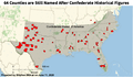 CSA Memorial Counties.png 600 × 351; 127 KB
-
 CSA State College DuBois, PA.jpg 812 × 454; 41 KB
-
 Ctf-distribution-map.jpg 1,000 × 630; 52 KB
-
 Danby State Forest Michigan Hollow and Abbot Loop (6641159967).png 1,100 × 850; 694 KB
-
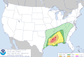 Day1otlk 20191216 1630 prt.gif 815 × 555; 27 KB
-
 Day1otlk sm.gif 190 × 129; 10 KB
-
 Day2otlk fire sep 6.gif 815 × 555; 27 KB
-
 DC & Falls Church, Va.png 390 × 730; 27 KB
-
 Delegates.svg 959 × 593; 37 KB
-
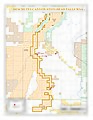 Deschutes Canyon - Steelhead Falls WSA (33269069462).jpg 2,550 × 3,300; 1.09 MB
-
 Deschutes Canyon WSA (33041777620).jpg 2,550 × 3,300; 1.08 MB
-
 EAR-ONS-"Punishment" map.png 1,024 × 767; 1.31 MB
-
 East coast port calls.gif 600 × 784; 85 KB
-
 East of Nerstrand Private Lands Wiki Version.JPG 3,398 × 4,082; 4.8 MB
-
 East-Point-Gun-Map-1945.jpg 1,851 × 1,072; 649 KB
-
 Electrification System of New York Connecting Railroad map.png 362 × 540; 50 KB
-
 En Honor a los Granjeros de Nacionalidad Hispana - Flickr - USDAgov.jpg 1,793 × 1,200; 902 KB
-
 Eww-outisde route.jpg 464 × 419; 50 KB
-
 Example of hatches on a shaded map.png 190 × 203; 31 KB
-
 Faithless elector states.svg 959 × 593; 62 KB
-
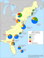
 Family Radio stations.png 7,720 × 4,022; 2.72 MB
-
 Figure 1- Illustration of Base Premium Interactive Map (15291011000).jpg 2,250 × 1,951; 487 KB
-

-

-
-

-
-

-

-

-
-
-

-
-

-

-

-

-

-

-

-

-
-

-
-

-
-
-
-

-

-
-
-
-
-

-

-

-

-

-
-

-

-

-
-

-
-

-

-
-
-
-

-
 FloridaTornadoWatch.jpg 730 × 552; 130 KB
.jpg)
%27_(11228979266).jpg)
.jpg)
%27_(11227678063).jpg)
.jpg)
_C._H._Hitchcock,_State_Geologist,_J._H._Huntington,_Principal_Assistant%27_(11104690203).jpg)
%27_(11304463646).jpg)
.jpg)
.jpg)
.jpg)
.jpg)
.jpg)
.jpg)
.jpg)
.jpg)
%27_(11136376345).jpg)
%27_(11281661896).jpg)
_with_England._..._Fourth_thousand%27_(11041947634).jpg)
%27_(11305423964).jpg)
.jpg)

.jpg)
.jpg)
.jpg)
%27_(11228487684).jpg)


%27_(11217991856).jpg)
%27_(11085023424).jpg)
.jpg)
%27_(11118080014).jpg)
)%27_(11181410495).jpg)
%27_(11006694223).jpg)
.jpg)
.jpg)
%27_(11232490193).jpg)
.jpg)
.jpg)
.jpg)
.jpg)
.jpg)
%27_(11139584975).jpg)
.jpg)
.jpg)
_Chicago,_the_Wonder_City%27_(11302303975).jpg)
_Annual_Report_on_the_Geology_of_the_State_of_Vermont%27_(11024518294).jpg)
.jpg)
%27_(11304395265).jpg)
.jpg)
)%27_(11177330594).jpg)
%27_(11119719704).jpg)
.jpg)
_..._With_illustrations%27_(11192524993).jpg)
.jpg)
.jpg)
_..._Edited,_with_notes,_by_J._R._Gilmore%27_(11250886883).jpg)
%27_(11099305695)_(2).jpg)
.jpg)
.jpg)
.jpg)
.jpg)
.jpg)
%27_(11251108196).jpg)
)%27_(11180672156).jpg)
.jpg)
.jpg)
.jpg)
.jpg)
.jpg)
.jpg)
.jpg)
.jpg)


.jpg)
.jpg)
.jpg)

.jpg)
.jpg)
.jpg)

.jpg)
_(14579726547).jpg)
_(14598091850).jpg)

_(18416184191).jpg)
_(14779295372).jpg)
_(17807430684).jpg)

_(14756409495).jpg)


_(14568720799).jpg)


_(14756576396).jpg)
_(19886559504).jpg)

.jpg)


_(20695196941).jpg)


.png)


.jpg)
.jpg)


.jpg)
.jpg)
_Methodology_for_Calculating_Estimated_Veteran_Population_Served_for_Skagit_County_and_Chelan_County_(15203907531).jpg)
_(2014)_(17124461638).jpg)
_Apprehensions_of_Unaccompanied_Alien_Children_(UAC),_Fiscal_Years_2009_through_2014_(20180827518).jpg)
.jpg)
.jpg)
.jpg)
.jpg)
.jpg)
.jpg)
.jpg)
.jpg)
.jpg)
.jpg)
.jpg)
.jpg)
.jpg)
.jpg)
.jpg)
.jpg)
.jpg)
.jpg)
.jpg)
.jpg)
.jpg)
.jpg)
.jpg)
.jpg)
.jpg)
.jpg)
.jpg)
.jpg)
.jpg)
.jpg)
.jpg)
.jpg)
.jpg)
.jpg)
.jpg)
.jpg)
.jpg)
.jpg)
.jpg)
.jpg)
.jpg)
.jpg)
.jpg)
.jpg)
.jpg)
.jpg)

.jpg)
.jpg)
.jpg)
.jpg)
.jpg)