Category:United Kingdom photographs taken on 2007-12-05
Jump to navigation
Jump to search
Countries of Europe: Austria · France‡ · Georgia‡ · Germany · Hungary · Republic of Ireland · Italy · Lithuania · Netherlands‡ · Poland · Portugal‡ · Romania · Russia‡ · Serbia · Spain‡ · Switzerland · Turkey‡ · United Kingdom
‡: partly located in Europe
‡: partly located in Europe
| ← | 5 December 2007 | → | ||
| ← | December 2007 | → | ||

United Kingdom photographs taken on 5 December 2007.
Image files should be categorized here automatically using {{taken on}} template. Direct categorisation is also possible, if automatic is impossible.
Subcategories
This category has the following 3 subcategories, out of 3 total.
Media in category "United Kingdom photographs taken on 2007-12-05"
The following 200 files are in this category, out of 464 total.
(previous page) (next page)-
 "Para Handy" on the Vital Spark - geograph.org.uk - 1013842.jpg 640 × 480; 67 KB
-
 A seasonal stream in season - geograph.org.uk - 1608757.jpg 428 × 640; 173 KB
-
 A643 Ingram Distributor Road Tunnel - geograph.org.uk - 627895.jpg 640 × 387; 237 KB
-
 Access to Learney Hotel - geograph.org.uk - 627745.jpg 480 × 640; 103 KB
-
 Albion Street Working Men's Club - geograph.org.uk - 628203.jpg 640 × 481; 33 KB
-
 All Saints - Church Street - geograph.org.uk - 628205.jpg 640 × 535; 27 KB
-
 Angrymire Laithe - geograph.org.uk - 629115.jpg 640 × 480; 60 KB
-
 Balgownie Links golf club - geograph.org.uk - 627592.jpg 640 × 480; 66 KB
-
 Bark Lane - geograph.org.uk - 629120.jpg 640 × 480; 78 KB
-
 Beech Way - geograph.org.uk - 627649.jpg 640 × 480; 58 KB
-
 Bennet Road, Reading - geograph.org.uk - 630964.jpg 640 × 480; 108 KB
-
 Bennet Road, Reading - geograph.org.uk - 630974.jpg 640 × 480; 100 KB
-
 Beverley, Saturday Market - panoramio.jpg 1,041 × 693; 273 KB
-
 Birtley Crematorium - geograph.org.uk - 637440.jpg 640 × 480; 75 KB
-
 Black Loch - geograph.org.uk - 627638.jpg 640 × 322; 28 KB
-
 Blocked up sheephole - geograph.org.uk - 629163.jpg 640 × 480; 123 KB
-
 Boardwalk by River Don estuary - geograph.org.uk - 627602.jpg 640 × 480; 73 KB
-

-
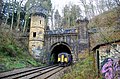 Bramhope Tunnel north portal with train.jpg 640 × 424; 124 KB
-
 Bridge over the West Glen River - geograph.org.uk - 629009.jpg 640 × 427; 77 KB
-
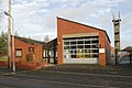
 Brixworth fire station - geograph.org.uk - 629688.jpg 640 × 427; 242 KB
-
 Broadwalk House, Exeter - geograph.org.uk - 631549.jpg 472 × 640; 84 KB
-
 Brockhole Lane - geograph.org.uk - 629044.jpg 640 × 480; 115 KB
-

-
 Buildings old and new - geograph.org.uk - 627971.jpg 640 × 480; 86 KB
-
 Bull's Hill Farm - geograph.org.uk - 629484.jpg 640 × 480; 90 KB
-
 Church Lane, Burton-le-Coggles - geograph.org.uk - 629677.jpg 640 × 427; 102 KB
-
 Burton Latimer fire station - geograph.org.uk - 629711.jpg 640 × 426; 161 KB
-
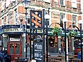 Camden Head, Islington - geograph.org.uk - 628049.jpg 640 × 479; 162 KB
-
 Carousel and candyfloss stall - geograph.org.uk - 631730.jpg 480 × 640; 110 KB
-
 Carousel, Exeter - geograph.org.uk - 628159.jpg 480 × 640; 123 KB
-
 Carr Road - Leeds Road - geograph.org.uk - 628417.jpg 640 × 469; 21 KB
-

-
 Catherine Street, Exeter - geograph.org.uk - 631685.jpg 480 × 640; 67 KB
-
 Charlie's Chippy - Leeds Road - geograph.org.uk - 628415.jpg 564 × 640; 34 KB
-
 Chester Cross and the Christmas lights - geograph.org.uk - 627978.jpg 640 × 480; 203 KB
-
 Christmas Lights in Brindley Place - geograph.org.uk - 641351.jpg 640 × 480; 95 KB
-

-
 Church of St. John the Baptist, Aconbury - geograph.org.uk - 628006.jpg 469 × 640; 136 KB
-
 Civic Centre, Exeter - geograph.org.uk - 628175.jpg 473 × 640; 96 KB
-
 Clarke Estate view - geograph.org.uk - 627651.jpg 640 × 480; 57 KB
-
 Coffee bar, Exeter station - geograph.org.uk - 628185.jpg 480 × 640; 61 KB
-
 Colebrooke Row, Islington - geograph.org.uk - 628137.jpg 640 × 480; 135 KB
-
 Commercial Road, Reading - geograph.org.uk - 630943.jpg 640 × 480; 102 KB
-
 Common frog (Rana temporaria) - geograph.org.uk - 668632.jpg 640 × 426; 108 KB
-
 Conservation Walk at Corby Pasture Farm - geograph.org.uk - 628974.jpg 640 × 427; 147 KB
-
 Copse at the Top of Moor Lane - geograph.org.uk - 630321.jpg 640 × 480; 68 KB
-
 Corby Pasture Farm - geograph.org.uk - 628970.jpg 640 × 427; 105 KB
-
 Corn Mill ruins in Hawarden Park - geograph.org.uk - 628583.jpg 640 × 480; 270 KB
-
 Corpus Christi Church, Tremeirchion - geograph.org.uk - 627728.jpg 640 × 480; 71 KB
-
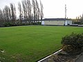 Crown Bowling Green - Savile Park - geograph.org.uk - 628196.jpg 640 × 480; 33 KB
-
 Cul-de-Sac - geograph.org.uk - 627641.jpg 640 × 480; 75 KB
-
 Cult, Exeter - geograph.org.uk - 628168.jpg 467 × 640; 85 KB
-
 Cunningly disguised WW2 defences - geograph.org.uk - 627928.jpg 480 × 640; 90 KB
-
 Daventry fire station - geograph.org.uk - 629553.jpg 640 × 427; 201 KB
-
 Dead end now - geograph.org.uk - 627678.jpg 640 × 480; 69 KB
-
 Desborough fire station - geograph.org.uk - 629693.jpg 640 × 427; 225 KB
-

-
 Dinorben Arms, Bodfari - geograph.org.uk - 627569.jpg 640 × 459; 66 KB
-
 Dippers' Cottage Apperley - geograph.org.uk - 627580.jpg 640 × 427; 110 KB
-

-
 Dry Stone Wall above Peart Crags - geograph.org.uk - 629085.jpg 640 × 480; 106 KB
-

-
 Duckmanton Lodge - Calow - geograph.org.uk - 627534.jpg 640 × 480; 54 KB
-
 Dudding Hill signal box in Gladstone Park (geograph 3585278).jpg 1,600 × 1,200; 568 KB
-
 Earthworks at Burton-le-Coggles - geograph.org.uk - 629679.jpg 640 × 427; 81 KB
-
 Earthworks at Burton-le-Coggles - geograph.org.uk - 629694.jpg 640 × 512; 91 KB
-
 Elmwood Parade - geograph.org.uk - 627645.jpg 640 × 480; 51 KB
-
 Elmwood Way - geograph.org.uk - 627646.jpg 640 × 480; 51 KB
-
 Entering Embsay - geograph.org.uk - 636874.jpg 640 × 480; 113 KB
-
 Entrance to Brynbella - geograph.org.uk - 627575.jpg 640 × 480; 122 KB
-
 Exeter Castle Ice Rink - geograph.org.uk - 628153.jpg 514 × 640; 73 KB
-
 Exeter Castle Ice Rink - geograph.org.uk - 631790.jpg 640 × 480; 71 KB
-
 Exit from sea-wall parade - geograph.org.uk - 627576.jpg 640 × 480; 84 KB
-
 Falling Masonry - geograph.org.uk - 627788.jpg 480 × 640; 109 KB
-
 Farmhouse on the Nantlys Estate - geograph.org.uk - 627570.jpg 640 × 480; 96 KB
-
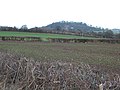
 Farmland between Hereford and Hoarwithy - geograph.org.uk - 627968.jpg 640 × 480; 123 KB
-
 Farmland by Lownd Wood - geograph.org.uk - 629714.jpg 640 × 512; 103 KB
-
 Farmland near Aconbury Hill - geograph.org.uk - 627974.jpg 640 × 480; 131 KB
-
 Fellend - geograph.org.uk - 627885.jpg 517 × 640; 81 KB
-
 Ffynnon Beuno Cave, Tremeirchion - geograph.org.uk - 627574.jpg 640 × 480; 94 KB
-
 Fields North of Eastby - geograph.org.uk - 636867.jpg 640 × 480; 58 KB
-
 Fleetgate, Barton-Upon-Humber - geograph.org.uk - 627741.jpg 537 × 640; 116 KB
-
 Floating Dock,Bristol - geograph.org.uk - 628535.jpg 630 × 472; 85 KB
-
 Fly tipping and mud - geograph.org.uk - 627666.jpg 640 × 480; 87 KB
-
 Folkingham from Greenfields Lane - geograph.org.uk - 628710.jpg 640 × 427; 97 KB
-
 Food stall, Guildhall shopping centre - geograph.org.uk - 631749.jpg 480 × 640; 128 KB
-
 Food stalls, Guildhall shopping centre - geograph.org.uk - 631742.jpg 480 × 640; 120 KB
-
 Footbridge over Shield Burn - geograph.org.uk - 628604.jpg 640 × 480; 155 KB
-
 Footbridge over Shield Burn - geograph.org.uk - 628615.jpg 640 × 480; 141 KB
-
 Footpath below Moorhouse Gate - geograph.org.uk - 629523.jpg 640 × 480; 107 KB
-
 Footpath near Forstersteads - geograph.org.uk - 628557.jpg 640 × 480; 126 KB
-
 Footpath to Housty - geograph.org.uk - 629526.jpg 640 × 480; 141 KB
-
 Gala Bingo - Park Road - geograph.org.uk - 628245.jpg 640 × 413; 20 KB
-
 George Street , Hull - geograph.org.uk - 628480.jpg 640 × 623; 125 KB
-

-
 Giraffe, Exeter - geograph.org.uk - 631550.jpg 480 × 640; 73 KB
-

-
 Grafton Street - geograph.org.uk - 628423.jpg 640 × 480; 29 KB
-
 Grange Court - Front Street - geograph.org.uk - 628413.jpg 640 × 395; 29 KB
-
 Greenfields Lane - geograph.org.uk - 628536.jpg 640 × 427; 129 KB
-

-
 Grimston Street, Hull - geograph.org.uk - 627970.jpg 640 × 483; 87 KB
-
 Guilsborough fire station - geograph.org.uk - 629682.jpg 640 × 427; 187 KB
-
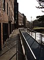
 Handrail, Queen's Walk, Exeter - geograph.org.uk - 631760.jpg 469 × 640; 86 KB
-
 Harrison's Farm - geograph.org.uk - 628980.jpg 640 × 427; 85 KB
-
 Hawthorn Way - geograph.org.uk - 627643.jpg 640 × 480; 59 KB
-
 Hazelwood Drive - geograph.org.uk - 627663.jpg 640 × 480; 53 KB
-
 Hereford Crematorium Chapel - geograph.org.uk - 627609.jpg 640 × 480; 160 KB
-
 High tide in the Don estuary - geograph.org.uk - 627588.jpg 640 × 480; 84 KB
-
 Hightown - Lumley Street - geograph.org.uk - 628199.jpg 640 × 440; 28 KB
-
 History in a wall - Chilwell - geograph.org.uk - 628143.jpg 640 × 427; 134 KB
-
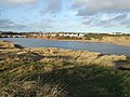
 Holbeton, Erme estuary - geograph.org.uk - 628003.jpg 640 × 427; 196 KB
-
 Holbeton, Meadowsfoot Beach - geograph.org.uk - 628030.jpg 640 × 427; 150 KB
-
 Holbeton, Mothecombe House - geograph.org.uk - 628034.jpg 640 × 427; 187 KB
-
 Holbeton, near the mouth of the Erme - geograph.org.uk - 627999.jpg 640 × 427; 157 KB
-
 Holbeton, old limekiln - geograph.org.uk - 628016.jpg 640 × 427; 223 KB
-
 Holbeton, on Owen's Hill - geograph.org.uk - 628026.jpg 640 × 427; 316 KB
-
 Holbeton, seaweed - geograph.org.uk - 628024.jpg 640 × 427; 305 KB
-
 Holbeton, towards Erme mouth - geograph.org.uk - 628021.jpg 640 × 427; 171 KB
-
 Holbeton, watercourse - geograph.org.uk - 628012.jpg 640 × 427; 233 KB
-
 Houses in Donmouth Road - geograph.org.uk - 627634.jpg 640 × 480; 89 KB
-
 Irnham Road - geograph.org.uk - 628982.jpg 640 × 427; 108 KB
-
 Joffre Avenue - Leeds Road - geograph.org.uk - 628429.jpg 640 × 385; 22 KB
-

-
 Kennet Island, Reading - geograph.org.uk - 630897.jpg 640 × 480; 123 KB
-
 Lamplighters - Carlton Street - geograph.org.uk - 628210.jpg 640 × 481; 30 KB
-
 Law Courts, Exeter Castle - geograph.org.uk - 631775.jpg 522 × 640; 70 KB
-
 Layby and hill beside A44 - geograph.org.uk - 643251.jpg 640 × 480; 66 KB
-
 Level Crossing - High Street - geograph.org.uk - 628202.jpg 640 × 423; 28 KB
-
 Lisheen Avenue - Leeds Road - geograph.org.uk - 628425.jpg 640 × 378; 27 KB
-
 Converted chapel in Llandyrnog - geograph.org.uk - 627562.jpg 640 × 480; 65 KB
-
 Lonely Sign on Brown Bank - geograph.org.uk - 634387.jpg 640 × 480; 66 KB
-
 Long Buckby fire station - geograph.org.uk - 629569.jpg 640 × 427; 175 KB
-
 Looking northwest - geograph.org.uk - 627802.jpg 480 × 640; 55 KB
-
 Lumley Street - geograph.org.uk - 628194.jpg 640 × 340; 17 KB
-
 Magpie lifeguard - geograph.org.uk - 627617.jpg 640 × 480; 37 KB
-
 Malt Shovel - Front Street - geograph.org.uk - 628410.jpg 640 × 486; 34 KB
-
 Manor Lane, Burton-le-Coggles - geograph.org.uk - 629208.jpg 640 × 427; 74 KB
-
 Mason's Arms, Eastby - geograph.org.uk - 629108.jpg 640 × 480; 61 KB
-
 Moor Lane (North) - geograph.org.uk - 629148.jpg 640 × 480; 62 KB
-
 Moor Lane (South) - geograph.org.uk - 629138.jpg 640 × 480; 78 KB
-

-

-
 New flats on Berryden Road - geograph.org.uk - 627725.jpg 640 × 480; 66 KB
-
 New office development - geograph.org.uk - 627983.jpg 640 × 480; 100 KB
-
 Newport Street, Barton Upon Humber - geograph.org.uk - 627755.jpg 640 × 482; 113 KB
-
 Newton and Noss, by Kilpatrick Steps - geograph.org.uk - 628051.jpg 640 × 427; 186 KB
-
 Newton and Noss, Newton Creek - geograph.org.uk - 628044.jpg 640 × 427; 157 KB
-
 Newton and Noss, Noss Creek - geograph.org.uk - 628037.jpg 640 × 427; 166 KB
-
 Newton and Noss, Noss Mayo - geograph.org.uk - 628039.jpg 640 × 427; 190 KB
-
 Newton and Noss, the Yealm - geograph.org.uk - 628046.jpg 640 × 427; 226 KB
-
 Night-time on the Thames - geograph.org.uk - 748187.jpg 640 × 426; 61 KB
-

-
 Niphon Works Building, Wolverhampton - geograph.org.uk - 627596.jpg 640 × 441; 142 KB
-
 Niphon Works Building, Wolverhampton - geograph.org.uk - 627601.jpg 503 × 640; 121 KB
-
 No swimming in the Don^ - geograph.org.uk - 627636.jpg 640 × 480; 54 KB
-
 North end of beach Boulevard - geograph.org.uk - 627551.jpg 640 × 480; 58 KB
-
 Norton Canes Services on M6 Toll Road - geograph.org.uk - 627779.jpg 640 × 480; 59 KB
-
 Newton and Noss, the Swan Inn - geograph.org.uk - 628040.jpg 640 × 427; 181 KB
-
 Oakham fire station - geograph.org.uk - 629535.jpg 640 × 427; 201 KB
-
 Oaklands Way Open Space - geograph.org.uk - 627656.jpg 640 × 480; 46 KB
-
 Old field gate - geograph.org.uk - 628120.jpg 640 × 480; 104 KB
-
 Old School, Halkyn - geograph.org.uk - 627849.jpg 640 × 480; 87 KB
-

-
 Open-air Ice Rink - geograph.org.uk - 752560.jpg 640 × 426; 75 KB
-
 Oundle fire station - geograph.org.uk - 629794.jpg 640 × 427; 260 KB
-
 Oystercatchers foraging - geograph.org.uk - 627658.jpg 640 × 480; 83 KB
-

-
 Pasture north of Bishopstone, Wiltshire - geograph.org.uk - 627860.jpg 640 × 480; 277 KB
-

-
 Penbryn Mawr Standing Stone. - geograph.org.uk - 1148695.jpg 640 × 480; 87 KB
-
 Pontifex Maximus - geograph.org.uk - 627699.jpg 640 × 480; 54 KB
-
 Post Office - Front Street - geograph.org.uk - 628412.jpg 640 × 480; 30 KB
-
 Preaching cross, Tremeirchion Church - geograph.org.uk - 627724.jpg 480 × 640; 136 KB
-
 Princesshay car park - geograph.org.uk - 628170.jpg 480 × 640; 130 KB
-
 Princesshay car park - geograph.org.uk - 628171.jpg 480 × 640; 99 KB
-
 Princesshay car park - geograph.org.uk - 631548.jpg 480 × 640; 130 KB
-
 Princesshay Square - geograph.org.uk - 631555.jpg 484 × 640; 86 KB
-
 Principles, Exeter - geograph.org.uk - 631552.jpg 460 × 640; 75 KB
-
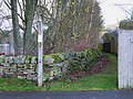
 Public footpath to Beacon Lane - geograph.org.uk - 628597.jpg 640 × 427; 75 KB
-
 Puddle, Exeter - geograph.org.uk - 628104.jpg 479 × 640; 81 KB
-
 RAFA Flarepath Club - Pontefract Road - geograph.org.uk - 628215.jpg 640 × 480; 30 KB
-
 Rainbow over Gateway park - geograph.org.uk - 628089.jpg 640 × 426; 49 KB
-
 Red Lion, Rhosesmor - geograph.org.uk - 628002.jpg 640 × 480; 59 KB
-
 Redevelopment, south Reading - geograph.org.uk - 630932.jpg 640 × 480; 114 KB
-
 Reflection - geograph.org.uk - 627990.jpg 640 × 480; 72 KB
-
 Reflection in a bauble - geograph.org.uk - 628165.jpg 470 × 640; 88 KB
-
 Reflection, Princesshay - geograph.org.uk - 631551.jpg 480 × 640; 69 KB
-
 Reiss, Exeter - geograph.org.uk - 628163.jpg 480 × 640; 71 KB
-
 Ricoh Arena - Coventry - geograph.org.uk - 627785.jpg 640 × 480; 62 KB
-

-
 Road bridge over stream at Aconbury - geograph.org.uk - 628017.jpg 640 × 480; 151 KB
-
 Roadworks near Green Crize - geograph.org.uk - 627946.jpg 640 × 460; 164 KB
-
 Robin Hood Street - Pontefract Road - geograph.org.uk - 628217.jpg 640 × 412; 23 KB
-
 Royal Oak, Caerwys - geograph.org.uk - 627842.jpg 640 × 480; 65 KB
-
 Sainsburys Berryden Superstore Aberdeen by Stanley Howe.jpg 640 × 480; 62 KB
-
 Salem, Pentre Halkyn - geograph.org.uk - 627845.jpg 640 × 480; 61 KB
-
 Salusbury Arms, Tremeirchion - geograph.org.uk - 627716.jpg 640 × 480; 86 KB
-
 School Lane - off Front Street - geograph.org.uk - 628409.jpg 640 × 594; 31 KB


_-_geograph.org.uk_-_668632.jpg)


.jpg)


_-_geograph.org.uk_-_629148.jpg)
_-_geograph.org.uk_-_629138.jpg)


_Wolverhampton_-_geograph.org.uk_-_627611.jpg)


