Category:United States Senate election maps of Illinois (set)
Jump to navigation
Jump to search
States of the United States: Alabama · Alaska · Arizona · Arkansas · California · Colorado · Connecticut · Delaware · Florida · Hawaii · Idaho · Illinois · Indiana · Iowa · Kansas · Kentucky · Louisiana · Maine · Maryland · Massachusetts · Michigan · Minnesota · Mississippi · Missouri · Montana · Nebraska · Nevada · New Hampshire · New Jersey · New Mexico · New York · North Carolina · North Dakota · Ohio · Oklahoma · Oregon · Pennsylvania · Rhode Island · South Carolina · South Dakota · Tennessee · Texas · Utah · Vermont · Virginia · Washington · West Virginia · Wisconsin · Wyoming
This category is an image set. It should contain only images that have the same style, and should have a parent category that is purely topical.


square
1914-1944
1914-1944


vertical
1948-2022
1948-2022
This set contains files in mismatched formats. (See imagemaps on the right.)
Ideally the maps from 1914-1944 should be overwritten with new files based on File:Illinois county map, cb 500k.svg. (This can not be done by cropping.)
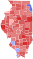
D >90%
D 80-90%
D 70-80%
D 60-70%
D 50-60%
D <50%
R <50%
R 50-60%
R 60-70%
R 70-80%
R 80-90%
R >90%
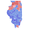
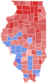
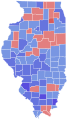
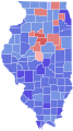
Media in category "United States Senate election maps of Illinois (set)"
The following 41 files are in this category, out of 41 total.
-
 1914 United States Senate election in Illinois results map by county.svg 744 × 744; 283 KB
-
 1918 United States Senate election in Illinois results map by county.svg 744 × 744; 302 KB
-
 1920 United States Senate election in Illinois results map by county.svg 744 × 744; 283 KB
-
 1924 United States Senate election in Illinois results map by county.svg 744 × 744; 283 KB
-
 1926 United States Senate election in Illinois results map by county.svg 744 × 744; 283 KB
-
-
 1930 United States Senate election in Illinois results map by county.svg 744 × 744; 283 KB
-
 1932 United States Senate election in Illinois results map by county.svg 744 × 744; 283 KB
-
 1936 United States Senate election in Illinois results map by county.svg 744 × 744; 283 KB
-
 1938 United States Senate election in Illinois results map by county.svg 744 × 744; 285 KB
-

-
 1942 United States Senate election in Illinois results map by county.svg 744 × 744; 283 KB
-
 1944 United States Senate election in Illinois results map by county.svg 744 × 744; 285 KB
-

-
-

-

-

-

-

-

-

-

-
-

-

-

-
-
-
-
-

-
-

-

-

-
-

-

-

-
