Category:Vesting Oudeschans
Jump to navigation
Jump to search
| Object location | | View all coordinates using: OpenStreetMap |
|---|
 | |||||
| Upload media | |||||
| Instance of |
| ||||
|---|---|---|---|---|---|
| Location | Westerwolde, Groningen, Netherlands | ||||
| Street address |
| ||||
| Heritage designation |
| ||||
 | |||||
Deel van de Aa dat als vestinggracht om de vesting loopt
|
This is a category about rijksmonument number 8919
|
Bastionvormig terrein begrensd door de Aa
|
This is a category about rijksmonument number 8920
|
| Address |
|
Media in category "Vesting Oudeschans"
The following 23 files are in this category, out of 23 total.
-
 Aanduiding bastion in noord-oosten - Oudeschans - 20179298 - RCE.jpg 1,197 × 1,200; 387 KB
-
 Aanduiding Vestinggracht in zuid-oosten - Oudeschans - 20179262 - RCE.jpg 1,195 × 1,200; 490 KB
-
 Aanduiding vestinggracht in zuid-oosten - Oudeschans - 20179265 - RCE.jpg 1,190 × 1,200; 357 KB
-
 Aanduiding vestingwerken vanaf zuidoosten - Oudeschans - 20179267 - RCE.jpg 1,192 × 1,200; 458 KB
-
 Luchtfoto's - Oudeschans - 20179325 - RCE.jpg 1,195 × 1,200; 330 KB
-
 Luchtfoto's - Oudeschans - 20179326 - RCE.jpg 1,185 × 1,200; 393 KB
-
 Luchtfoto's - Oudeschans - 20179327 - RCE.jpg 3,018 × 3,030; 4.2 MB
-
 Luchtfoto's - Oudeschans - 20179328 - RCE.jpg 1,200 × 1,200; 339 KB
-
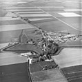
 NIMH - 2011 - 1050 - Aerial photograph of Oude Schans, The Netherlands - 1920 - 1940.jpg 3,500 × 2,556; 1.96 MB
-
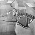
 NIMH - 2011 - 1051 - Aerial photograph of Oude Schans, The Netherlands - 1920 - 1940.jpg 3,500 × 2,570; 1.67 MB
-
 Oudeschans klapbrug.jpg 7,693 × 4,974; 11.33 MB
-
 Oudeschans vestingwerken.jpg 1,069 × 783; 218 KB
-
 Poortbrug - Oudeschans - 20179278 - RCE.jpg 1,197 × 1,200; 323 KB
-
 Poortbrug - Oudeschans - 20179280 - RCE.jpg 1,184 × 1,200; 295 KB
-
 Poortbrug in westen - Oudeschans - 20179279 - RCE.jpg 1,188 × 1,200; 314 KB
-
 Vestinggracht in noord-westen - Oudeschans - 20179266 - RCE.jpg 1,195 × 1,200; 300 KB
-
 Vestinggracht in noord-westen - Oudeschans - 20179268 - RCE.jpg 1,190 × 1,200; 400 KB
-
 Vestinggracht in noord-westen - Oudeschans - 20179269 - RCE.jpg 1,185 × 1,200; 419 KB
-
 Vestinggracht in zuiden naar dorpskern - Oudeschans - 20179263 - RCE.jpg 1,197 × 1,200; 352 KB
-
 Vestinggracht naar noord-westen - Oudeschans - 20179271 - RCE.jpg 1,200 × 1,200; 347 KB
-
 Vestinggracht vanaf poortbrug naar 't zuid-westen - Oudeschans - 20179270 - RCE.jpg 1,192 × 1,200; 275 KB
-
 Vestinggracht vanuit 't oosten - Oudeschans - 20179264 - RCE.jpg 1,192 × 1,200; 359 KB
-


