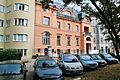
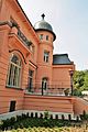
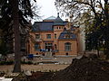
Category:Villa Löw-Beer (Černá Pole)
Jump to navigation
Jump to search
| Object location | | View all coordinates using: OpenStreetMap |
|---|
villa in Brno-Černá Pole  .jpg) | |||||
| Upload media | |||||
| Instance of | |||||
|---|---|---|---|---|---|
| Location |
| ||||
| Conscription number |
| ||||
| Located on street |
| ||||
| Architectural style | |||||
| Architect | |||||
| Heritage designation | |||||
 | |||||
|
This is a category about a cultural monument of the Czech Republic,
number: 41917/7-6987. |
Subcategories
This category has the following 2 subcategories, out of 2 total.
G
I
- Interior of Villa Löw-Beer (32 F)
Media in category "Villa Löw-Beer (Černá Pole)"
The following 23 files are in this category, out of 23 total.
-
 Brno, Drobného 22, Vila Löw-Beer (6937).jpg 3,888 × 2,592; 2.82 MB
-
 Brno, Drobného 22, Vila Löw-Beer (6939).jpg 3,888 × 2,592; 2.55 MB
-
 Brno, Drobného 22, Vila Löw-Beer (6949).jpg 2,592 × 3,888; 1.99 MB
-
 Brno, Drobného 22, Vila Löw-Beer (6954).jpg 2,592 × 3,888; 2.06 MB
-
 Brno, Drobného 22, Vila Löw-Beer - balkon (6941).jpg 2,592 × 3,888; 2.99 MB
-
 Brno, Drobného 22, Vila Löw-Beer - dveře (6944).jpg 2,592 × 3,888; 2.55 MB
-
 Brno, Drobného 22, Vila Löw-Beer - infotabule (6946).jpg 3,888 × 2,592; 2.26 MB
-
 Brno, Drobného 22, Vila Löw-Beer - okno (6940).jpg 2,020 × 3,030; 1.06 MB
-
 Brno, Drobného 22, Vila Löw-Beer - průchod (6950).jpg 2,592 × 3,888; 2.61 MB
-
 Brno, Drobného 22, Vila Löw-Beer - vstup (6942).jpg 2,391 × 3,587; 1.59 MB
-
 Brno, Vila Löw-Beer a fomtána.jpg 3,672 × 4,896; 5.26 MB
-
 Brno, Vila Löw-Beer ze zahrady (1).jpg 4,896 × 3,672; 5.93 MB
-
 Brno, Vila Löw-Beer ze zahrady (2).jpg 4,896 × 3,672; 6.09 MB
-
 Brno, Vila Löw-Beer, detail fasády.jpg 3,672 × 4,896; 4.83 MB
-
 Brno, Vila Löw-Beer, detail oplocení.jpg 3,672 × 4,896; 6.37 MB
-
 Brno, Vila Löw-Beer, dveře do zahrady.jpg 3,672 × 4,896; 5.81 MB
-
 Brno, Vila Löw-Beer, pohled ze zahrady.jpg 4,675 × 3,420; 5.16 MB
-
 Brno, Vila Löw-Beer, vchod.jpg 3,672 × 4,896; 4.99 MB
-
 Drobneho22P2090018.JPG 4,288 × 3,216; 5.61 MB
-
 Vila Löw-Beer Brno 2016 1.jpg 2,200 × 2,030; 3.16 MB
-
 Vila Löw-Beer Brno 2016 2.jpg 3,000 × 1,926; 4.39 MB
-
 Vila Löw-Beer Brno 2016 3.jpg 2,400 × 1,631; 3.07 MB
-
 Vila Löw-Beer v Brně.JPG 3,648 × 2,736; 4.12 MB
.jpg)
.jpg)
.jpg)
.jpg)
.jpg)
.jpg)
.jpg)
.jpg)
.jpg)
.jpg)

.jpg)
.jpg)


