Category:Voorstraat 57, Kollum
Jump to navigation
Jump to search
| Object location | | View all coordinates using: OpenStreetMap |
|---|
building in Kollumerland en Nieuwkruisland, Netherlands  | |||||
| Upload media | |||||
| Instance of | |||||
|---|---|---|---|---|---|
| Location | Kollum, Noardeast-Fryslân, Friesland, Netherlands | ||||
| Street address |
| ||||
| Located on street |
| ||||
| Heritage designation |
| ||||
 | |||||
|
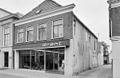
This is a category about rijksmonument number 23733
|
| Address |
|
Media in category "Voorstraat 57, Kollum"
The following 3 files are in this category, out of 3 total.
-
 Exterieur OVERZICHT VOORGEVELS - Kollum - 20277038 - RCE.jpg 1,200 × 955; 229 KB
-
 Exterieur VOORGEVEL - Kollum - 20292024 - RCE.jpg 1,200 × 780; 190 KB
-
 Kollum - Voorstraat 57.jpg 2,918 × 2,590; 2.98 MB

