Category:Wadi el-Arish
Jump to navigation
Jump to search
Media in category "Wadi el-Arish"
The following 19 files are in this category, out of 19 total.
-
 1856 Kiepert Map of the Sinai Peninsula, Egypt - Geographicus - Sinai-kiepert-1856.jpg 3,500 × 4,449; 4.12 MB
-
 Abteilung für Kriegskarten- und Vermessungswesen, Sinai Halbinsel (FL35476308 2690761).jpg 16,639 × 14,254; 311.55 MB
-
 Canterbury Mounted Rifles in the Wadi el Arish.jpg 633 × 332; 28 KB
-
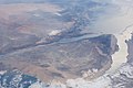
 ISS023-E-37904 - View of Earth.jpg 4,288 × 2,848; 868 KB
-
 ISS029-E-13700 - View of Jordan.jpg 4,288 × 2,848; 1.34 MB
-
 ISS029-E-13703 - View of Egypt.jpg 4,288 × 2,848; 1.31 MB
-
 ISS030-E-5332 - View of Israel.jpg 4,288 × 2,848; 1.2 MB
-
 ISS030-E-5334 - View of Egypt.jpg 4,288 × 2,848; 1.17 MB
-
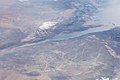 ISS030-E-5335 - View of Egypt.jpg 4,288 × 2,848; 1.15 MB
-
 ISS048-E-71349 - View of Earth.jpg 4,928 × 3,280; 1.31 MB
-
 ISS048-E-71361 - View of Earth.jpg 4,928 × 3,280; 1.5 MB
-
 ISS067-E-294666 - View of Earth.jpg 5,568 × 3,712; 1.88 MB
-
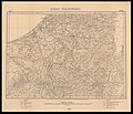
 Karte des peträischen Arabien und des Südlichen Theiles Von Sirien.jpg 6,930 × 9,229; 16.86 MB
-
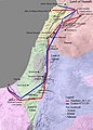 Map Land of Israel.jpg 571 × 800; 117 KB
-
 Ordnance Survey, Nekhl (FL35468107 2367585).jpg 13,956 × 16,221; 274.68 MB
-
 Palmer map of Northern Sinai and the Negev (with modern borders overlaid).jpg 1,748 × 1,702; 921 KB
-
 Sinai Peninsula - El Kossaima - War Office - btv1b101043153.jpg 13,074 × 15,273; 36.42 MB
-
 Sinai Peninsula - Suez - War Office - btv1b10104287h.jpg 17,658 × 14,797; 47.82 MB
-
 Sinai Peninsula - Yelleg East - War Office - btv1b10104314n.jpg 13,446 × 15,834; 39.77 MB

.jpg)


.jpg)
.jpg)


