Category:Wagenaarweg 30, The Hague
Jump to navigation
Jump to search
| Object location | | View all coordinates using: OpenStreetMap |
|---|
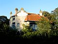
single-family detached home in The Hague, Netherlands  | |||||
| Upload media | |||||
| Instance of | |||||
|---|---|---|---|---|---|
| Location | The Hague, South Holland, Netherlands | ||||
| Street address |
| ||||
| Located on street | |||||
| Heritage designation |
| ||||
 | |||||
Nederlands: Villa de Zeemeeuw
|
This is a category about rijksmonument number 18075
|
| Address |
|
Media in category "Wagenaarweg 30, The Hague"
The following 4 files are in this category, out of 4 total.
-
 Aanzicht - 's-Gravenhage - 20091296 - RCE.jpg 1,200 × 807; 258 KB
-
 Den Haag Wagenaarweg 30 De Zeemeeuw.jpg 4,000 × 3,000; 1.38 MB
-
 Interieur, sgraffito - 's-Gravenhage - 20091297 - RCE.jpg 1,200 × 958; 275 KB
-
 Voorgevel van art nouveau-villa - 's-Gravenhage - 20396123 - RCE.jpg 1,200 × 924; 336 KB


