Category:Waldgreutturm
Jump to navigation
Jump to search
| Object location | | View all coordinates using: OpenStreetMap |
|---|
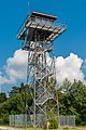
observation tower near Zainingen  | |||||
| Upload media | |||||
| Instance of | |||||
|---|---|---|---|---|---|
| Made from material | |||||
| Location | Gutsbezirk Münsingen, Reutlingen, Tübingen Government Region, Baden-Württemberg, Germany | ||||
| Operator | |||||
| Inception |
| ||||
| Height |
| ||||
| Elevation above sea level |
| ||||
| official website | |||||
 | |||||
Media in category "Waldgreutturm"
The following 10 files are in this category, out of 10 total.
-

-
 Münsingen Hardt - Beobachtungsturm Waldgreut im ehemaligen Truppenübungsplatz.jpg 2,041 × 2,435; 643 KB
-
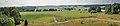 Panorama Waldgreutturm-pjt.jpg 3,000 × 651; 2.15 MB
-
 Turm Waldgreuth.JPG 2,736 × 3,648; 3.58 MB
-
 Waldgreutturm-01.jpg 3,240 × 4,320; 4.71 MB
-
 Waldgreutturm-02.jpg 3,240 × 4,320; 4.78 MB
-
 Waldgreutturm-03-Infotafeln.jpg 4,320 × 3,240; 5.75 MB
-
 Waldgreutturm-04-innen.jpg 4,320 × 3,240; 5.72 MB
-
 Waldgreutturm-05-Aussicht.jpg 4,320 × 3,240; 5.76 MB
-
 Waldgreutturm-pjt.jpg 1,996 × 3,000; 4.57 MB


