Category:Waldkapelle (Schäftlarn)
Jump to navigation
Jump to search
| Object location | | View all coordinates using: OpenStreetMap |
|---|
_Waldkapelle_234.jpg) | |||||
| Upload media | |||||
| Instance of | |||||
|---|---|---|---|---|---|
| Location | Schäftlarn, Munich, Upper Bavaria, Bavaria, Germany | ||||
| Street address |
| ||||
| Heritage designation | |||||
 | |||||
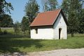
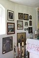
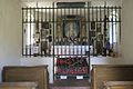
This is the category of the Bavarian Baudenkmal (cultural heritage monument) with the ID D-1-84-142-25 (Wikidata)
|
Deutsch: Schäftlarn, Zeller Straße/Neufahrner Straße, nahe Autobahn 95: Waldkapelle, kleiner Putzbau mit dreiseitigem Chorschluss, um 1630; mit Ausstattung.
Media in category "Waldkapelle (Schäftlarn)"
The following 8 files are in this category, out of 8 total.
-
 Neufahrn (Schäftlarn) Waldkapelle 234.jpg 4,896 × 3,264; 16.22 MB
-
 Neufahrn (Schäftlarn) Waldkapelle 235.jpg 2,176 × 3,264; 5.17 MB
-
 Neufahrn (Schäftlarn) Waldkapelle 236.jpg 3,264 × 4,896; 9.3 MB
-
 Neufahrn (Schäftlarn) Waldkapelle 237.jpg 4,871 × 3,247; 10.72 MB
-
 Neufahrn (Schäftlarn) Waldkapelle 238.jpg 4,849 × 3,232; 11.01 MB
-
 Neufahrn (Schäftlarn) Waldkapelle 239.jpg 4,896 × 3,264; 15.69 MB
-
 Neufahrn Waldkapelle-GO-1.jpg 2,592 × 1,944; 1.57 MB
-
 Neufahrn Waldkapelle-GO-2.jpg 2,592 × 1,944; 1.16 MB
_Waldkapelle_235.jpg)
_Waldkapelle_236.jpg)
_Waldkapelle_237.jpg)
_Waldkapelle_238.jpg)
_Waldkapelle_239.jpg)

