Category:Wasserturm Krempe
Jump to navigation
Jump to search
| Object location | | View all coordinates using: OpenStreetMap |
|---|
 | |||||
| Upload media | |||||
| Instance of | |||||
|---|---|---|---|---|---|
| Location | Krempe, Steinburg, Schleswig-Holstein, Germany | ||||
| Street address |
| ||||
| Heritage designation | |||||
 | |||||
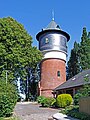
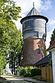
This is the category for an architectural monument.
It is on the list of cultural monuments of Krempe, no. 9789.
It is on the list of cultural monuments of Krempe, no. 9789.
Media in category "Wasserturm Krempe"
The following 6 files are in this category, out of 6 total.
-
 Krempe Wasserturm (2).jpg 1,536 × 2,048; 977 KB
-
 Krempe Wasserturm 2.jpg 1,024 × 768; 149 KB
-
 Krempe Wasserturm 2023.jpg 3,000 × 4,000; 3.11 MB
-
 Krempe Wasserturm-01.jpg 5,333 × 4,000; 14.57 MB
-
 Krempe Wasserturm-02.jpg 3,137 × 4,706; 7.61 MB
-
 Krempe Wasserturm.jpg 576 × 768; 142 KB
.jpg)


