Category:Waterhouse Building Block C
Jump to navigation
Jump to search
| Object location | | View all coordinates using: OpenStreetMap |
|---|
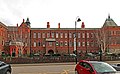
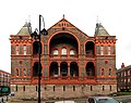
Originally the infirmary chapel and stores (at least on the ground floor)
Subcategories
This category has only the following subcategory.
Media in category "Waterhouse Building Block C"
The following 8 files are in this category, out of 8 total.
-
 Between blocks B & C, Waterhouse Building.jpg 4,818 × 3,007; 7.88 MB
-
 Block C, Waterhouse Building 1.jpg 4,565 × 2,809; 6.68 MB
-
 Block C, Waterhouse Building 2.jpg 4,578 × 3,449; 8.3 MB
-
 Block C, Waterhouse Building 3.jpg 3,786 × 3,007; 5.58 MB
-
 Block C, Waterhouse building.jpg 1,984 × 1,488; 639 KB
-
 Block C, Waterhouse Buildings, University of Liverpool.jpg 4,608 × 3,456; 4.07 MB
-
 Car park between blocks B & C, Liverpool Royal Infirmary.jpg 5,000 × 3,200; 8.95 MB
-
 Dover Street, University of Liverpool.jpg 4,608 × 3,456; 3.96 MB


