Category:Waterhouse Building Block H
Jump to navigation
Jump to search
| Object location | | View all coordinates using: OpenStreetMap |
|---|
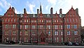
This was the Liverpool Royal Infirmary administration building, on Pembroke Place and has been separated from the former infirmary wards behind it. It is now home to Brownlow Group Practice.
Subcategories
This category has only the following subcategory.
E
Media in category "Waterhouse Building Block H"
The following 6 files are in this category, out of 6 total.
-
 Admin Block, Royal Liverpool Infirmary 2.jpg 1,984 × 1,488; 675 KB
-
 Admin Block, Royal Liverpool Infirmary 3.jpg 1,468 × 1,282; 355 KB
-
 Admin Block, Royal Liverpool Infirmary.jpg 1,456 × 1,920; 472 KB
-
 Brownlow Group Practice, Waterhouse Building.jpg 4,717 × 2,686; 6.7 MB
-
 Liverpool Royal Infirmary Administration Block (14652567595).jpg 3,072 × 2,304; 2.94 MB
-
 Rear of Brownlow Group Practice, Waterhouse Building.jpg 3,757 × 3,240; 6.68 MB


.jpg)
