Category:Wayside chapel Blutgasse 9, Hainburg
Jump to navigation
Jump to search
| Object location | | View all coordinates using: OpenStreetMap |
|---|
building in Hainburg an der Donau, Austria  | |||||
| Upload media | |||||
| Instance of | |||||
|---|---|---|---|---|---|
| Location | Hainburg an der Donau, Bruck an der Leitha District, Lower Austria, Austria | ||||
| Street address |
| ||||
| Heritage designation | |||||
 | |||||
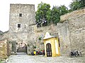
Deutsch: Die Kapelle unterhalb des Fischertors in Hainburg (Donau) wurde 1780 zur Erinnerung an die Opfer des Türkensturms von 1683 errichtet.
Media in category "Wayside chapel Blutgasse 9, Hainburg"
The following 3 files are in this category, out of 3 total.
-
 Hainburg Fischertor mit Kapelle.jpg 2,592 × 3,888; 7.67 MB
-
 Hainburg Kapelle Fischertor.jpg 2,592 × 3,888; 6.56 MB
-
 Hainburg, Fischertor..jpg 2,947 × 2,210; 4.21 MB

