Category:Wegekreuz Stieldorfer Straße 31 (Holtorf)
Jump to navigation
Jump to search
| Object location | | View all coordinates using: OpenStreetMap |
|---|
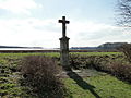
| This category shows a heritage building in Germany, located in the North Rhine-Westphalian city Bonn (no. A 2356). |
Media in category "Wegekreuz Stieldorfer Straße 31 (Holtorf)"
The following 6 files are in this category, out of 6 total.
-
 Oberholtorf-wegekreuz-stieldorfer-strasse-01.jpg 853 × 640; 249 KB
-
 Oberholtorf-wegekreuz-stieldorfer-strasse-02.jpg 573 × 860; 250 KB
-
 Oberholtorf-wegekreuz-stieldorfer-strasse-03.jpg 640 × 853; 177 KB
-
 Oberholtorf-wegekreuz-stieldorfer-strasse-04.jpg 573 × 860; 70 KB
-
 Oberholtorf-wegekreuz-stieldorfer-strasse-05.jpg 640 × 853; 224 KB
-
 Wegekreuz Stieldorfer Straße 31 (Holtorf).JPG 3,456 × 5,184; 5.53 MB


.JPG)