Category:Well House farmhouse, Frankby
Jump to navigation
Jump to search
| Object location | | View all coordinates using: OpenStreetMap |
|---|
This is a category about listed building number 1259866. |
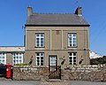
Grade II listed house in Frankby, Wirral, Merseyside, UK  | |||||
| Upload media | |||||
| Instance of | |||||
|---|---|---|---|---|---|
| Location | Frankby, Wirral, Merseyside, North West England, England | ||||
| Heritage designation |
| ||||
 | |||||
Media in category "Well House farmhouse, Frankby"
The following 6 files are in this category, out of 6 total.
-
 Datestone, Well House farmhouse, Frankby.jpg 3,241 × 2,816; 8.25 MB
-
 Frankby Green 2.JPG 3,648 × 2,736; 3.66 MB
-
 Garden wall of Well House farmhouse, Frankby.jpg 4,932 × 3,390; 15.97 MB
-
 Well House Farm, Frankby (geograph 2866104).jpg 640 × 427; 102 KB
-
 Well House Farm, Frankby Village.JPG 4,320 × 3,240; 2.83 MB
-
 Well House farmhouse, Frankby.jpg 4,329 × 3,447; 10.67 MB


.jpg)
