Category:Weststraat 79, Aardenburg
Jump to navigation
Jump to search
| Object location | | View all coordinates using: OpenStreetMap |
|---|
building in Sluis, Netherlands  | |||||
| Upload media | |||||
| Instance of | |||||
|---|---|---|---|---|---|
| Location | Aardenburg, Sluis, Zeeland, Netherlands | ||||
| Street address |
| ||||
| Located on street |
| ||||
| Heritage designation |
| ||||
 | |||||
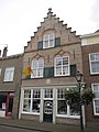
Nederlands: De Zwarte Haan
|
This is a category about rijksmonument number 6894
|
| Address |
|
Media in category "Weststraat 79, Aardenburg"
The following 5 files are in this category, out of 5 total.
-
 Aardenburg Weststraat 79 De Zwarte Haan.JPG 3,000 × 4,000; 2.44 MB
-
 Overzicht voorgevel met trapgevel en buurpand - Aardenburg - 20352919 - RCE.jpg 953 × 1,200; 238 KB
-
 Overzicht voorgevel winkelhuis - Aardenburg - 20321219 - RCE.jpg 793 × 1,200; 195 KB
-
 Voorgevel - Aardenburg - 20003834 - RCE.jpg 810 × 1,200; 212 KB
-


