Category:Whitecastle (community)
Jump to navigation
Jump to search
English: Whitecastle is a community in the principal area of Monmouthshire, Wales.
community in Monmouthshire, Wales | |||||
| Upload media | |||||
| Instance of | |||||
|---|---|---|---|---|---|
| Location | Monmouthshire, Wales | ||||
| Inception |
| ||||
 | |||||
Subcategories
This category has the following 6 subcategories, out of 6 total.
Media in category "Whitecastle (community)"
The following 83 files are in this category, out of 83 total.
-
 2024 Wales Monmouthshire Community Whitecastle map.svg 512 × 682; 603 KB
-
 A glimpse of the church at St. Maughans - geograph.org.uk - 6058097.jpg 1,024 × 768; 256 KB
-
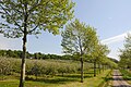 Apple Orchard - geograph.org.uk - 5780890.jpg 1,000 × 665; 856 KB
-
 Apple orchard near Penrhôs Fm - geograph.org.uk - 6235091.jpg 1,024 × 768; 1.17 MB
-
 B4347 towards Crossway - geograph.org.uk - 6111045.jpg 800 × 600; 111 KB
-
 Barn by the churchyard, St. Maughans - geograph.org.uk - 6058769.jpg 1,024 × 768; 199 KB
-
 Barn by the churchyard, St. Maughans - geograph.org.uk - 6058775.jpg 1,024 × 768; 337 KB
-
 Barns beside Offa's Dyke Path - geograph.org.uk - 6235085.jpg 1,024 × 768; 909 KB
-
 Black Bryony - geograph.org.uk - 6058133.jpg 768 × 1,024; 255 KB
-
 British Longhorn cattle in Abbey Meadow, 1987 - geograph.org.uk - 5754720.jpg 1,024 × 683; 239 KB
-
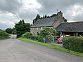
 Church Farm, St. Maughans - geograph.org.uk - 6058761.jpg 1,024 × 768; 138 KB
-
 Church of St. Maughan, interior looking east - geograph.org.uk - 6058106.jpg 1,024 × 770; 141 KB
-
 Dead cedar tree - geograph.org.uk - 6270142.jpg 1,024 × 768; 216 KB
-
 Farmland above Lower Hendre - geograph.org.uk - 6235084.jpg 1,024 × 768; 1.01 MB
-

-
 Fireplace at White Castle (Llanvetherine) - geograph.org.uk - 6021404.jpg 3,648 × 2,736; 4.75 MB
-
 Footpath to Greyfriars - geograph.org.uk - 5903554.jpg 1,024 × 768; 176 KB
-
 Footpath to St. Maughans - geograph.org.uk - 5903552.jpg 1,024 × 768; 180 KB
-
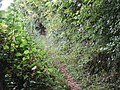 Footpath to St. Maughans - geograph.org.uk - 6058122.jpg 1,024 × 768; 348 KB
-
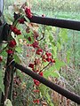
 Fruit bushes near Lower Grove - geograph.org.uk - 5903568.jpg 1,024 × 768; 181 KB
-
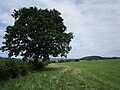
 Grass field and Court Wood - geograph.org.uk - 6270593.jpg 1,024 × 768; 250 KB
-
 Grass field and Pointers Wood - geograph.org.uk - 6270068.jpg 1,024 × 768; 230 KB
-
 Grass field by Tre-llwyfan - geograph.org.uk - 6270249.jpg 1,024 × 768; 215 KB
-
 Grass field near Little Park - geograph.org.uk - 6270133.jpg 1,024 × 768; 161 KB
-
 Grass field near Upper Cwm - geograph.org.uk - 6270256.jpg 1,024 × 768; 258 KB
-
 Grassland at Llanfaenor - geograph.org.uk - 6270047.jpg 1,024 × 768; 188 KB
-
 Grassland at Newcastle, Gwent - geograph.org.uk - 6270071.jpg 1,024 × 768; 278 KB
-
 Grazing and hedgerow, Norton - geograph.org.uk - 6111044.jpg 800 × 600; 148 KB
-
 Inner gatehouse, White Castle - geograph.org.uk - 6270096.jpg 1,024 × 768; 223 KB
-
 Inside White Castle (Outer Ward ^ Llanvetherine) - geograph.org.uk - 6022450.jpg 2,736 × 3,648; 4.67 MB
-
 Llanfihangel Ystum Llewern - St Michael's Church - geograph.org.uk - 6006141.jpg 5,184 × 2,920; 4.99 MB
-
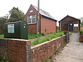 Llantilio Telephone Exchange - geograph.org.uk - 6162940.jpg 2,592 × 1,944; 1.36 MB
-
 Monument to John Hamilton - geograph.org.uk - 6058108.jpg 768 × 1,024; 186 KB
-
 Offa's Dyke Path at Llanfihangel-Ystern-Llewerrn - geograph.org.uk - 6270590.jpg 1,024 × 768; 323 KB
-
 Offa's Dyke Path by the Afon Troddi - geograph.org.uk - 6235088.jpg 1,024 × 768; 1.09 MB
-
 Offa's Dyke Path crossing a potato field - geograph.org.uk - 6235095.jpg 1,024 × 768; 1.17 MB
-
 Offa's Dyke Path leaving Llantilio Crossenny - geograph.org.uk - 6235093.jpg 1,024 × 768; 1.19 MB
-
 Offa's Dyke path near Hendre Farm - geograph.org.uk - 5745899.jpg 1,024 × 683; 165 KB
-

-

-

-
 On Offa's Dyke Path with view across valley of R Trothy - geograph.org.uk - 6006151.jpg 5,184 × 2,920; 6.09 MB
-

-
 On Offa's Dyke Path, NW of Hendre Farm, Worthybrook - geograph.org.uk - 6006139.jpg 5,184 × 2,920; 5.12 MB
-
 Pig in pasture at St. Maughans - geograph.org.uk - 6058113.jpg 1,024 × 768; 239 KB
-
 Recently harvested crops near Rockfield - geograph.org.uk - 6227329.jpg 4,032 × 2,268; 2.85 MB
-
 River Monnow near Rockfield - geograph.org.uk - 6227326.jpg 4,032 × 2,268; 4.12 MB
-
 Sign at White Castle (Llanvetherine) - geograph.org.uk - 6021366.jpg 3,648 × 2,736; 4.81 MB
-
 Sign at White Castle (Llanvetherine) - geograph.org.uk - 6021400.jpg 3,648 × 2,736; 4.68 MB
-
 Signs at White Castle (Llanvetherine) - geograph.org.uk - 5945898.jpg 3,648 × 2,736; 4.83 MB
-
 St Cenedlon's Church, Rockfield - geograph.org.uk - 6227330.jpg 4,032 × 2,268; 2.87 MB
-
 Sunnybank, Llanvihangel-Ystern-Llewern - geograph.org.uk - 6235089.jpg 1,024 × 768; 987 KB
-
 The church at St. Maughans - geograph.org.uk - 5903574.jpg 1,024 × 768; 178 KB
-
 The former church of St. Bueno - geograph.org.uk - 6270062.jpg 1,024 × 768; 176 KB
-
 The River Monnow below Tregate Bridge - geograph.org.uk - 5903579.jpg 1,024 × 768; 236 KB
-
 Three Castles Walk at White Castle - geograph.org.uk - 6270091.jpg 1,024 × 768; 342 KB
-
 Track to Little Coxstone - geograph.org.uk - 5903560.jpg 1,024 × 768; 287 KB
-
 Track to The Farm - geograph.org.uk - 6270076.jpg 1,024 × 768; 236 KB
-
 Tregate Bridge - geograph.org.uk - 5831236.jpg 665 × 1,000; 958 KB
-
 Tregate Bridge - geograph.org.uk - 6058731.jpg 1,024 × 768; 295 KB
-

-
 View from White Castle (Outer Ward ^ Llanvetherine) - geograph.org.uk - 6021490.jpg 3,648 × 2,736; 4.24 MB
-
 View from White Castle - geograph.org.uk - 5745989.jpg 683 × 1,024; 167 KB
-
-
 War Memorial at Llangattock-Vibon-Avel - geograph.org.uk - 6046834.jpg 768 × 1,024; 264 KB
-
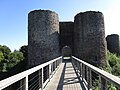
 White Castle (Gatehouse ^1 ^ Llanvetherine) - geograph.org.uk - 6021359.jpg 3,648 × 2,736; 4.77 MB
-
 White Castle (Gatehouse ^1 ^ Llanvetherine) - geograph.org.uk - 6021363.jpg 3,648 × 2,736; 4.74 MB
-
 White Castle (Gatehouse ^2 ^ Llanvetherine) - geograph.org.uk - 6022103.jpg 3,648 × 2,736; 4.25 MB
-
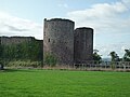
 White Castle (Llanvetherine) - geograph.org.uk - 5890585.jpg 3,648 × 2,736; 4.3 MB
-
 White Castle (Llanvetherine) - geograph.org.uk - 6021364.jpg 3,648 × 2,736; 4.75 MB
-
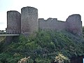
 White Castle (Llanvetherine) - geograph.org.uk - 6022101.jpg 3,648 × 2,736; 4.03 MB
-
 White Castle (Llanvetherine) - geograph.org.uk - 6022455.jpg 3,648 × 2,736; 4.27 MB
-
 White Castle (Moat ^ Llanvetherine) - geograph.org.uk - 6021390.jpg 3,648 × 2,736; 4.68 MB
-
 White Castle (Outer Ward ^ Llanvetherine) - geograph.org.uk - 5945930.jpg 3,648 × 2,736; 4.69 MB
-
 White Castle (Outer Ward ^ Llanvetherine) - geograph.org.uk - 6021379.jpg 3,648 × 2,736; 4.73 MB
-
 White Castle (Outer Ward ^ Llanvetherine) - geograph.org.uk - 6022098.jpg 3,648 × 2,736; 4.76 MB
-
 White Castle - geograph.org.uk - 6235104.jpg 1,024 × 768; 1.08 MB
-
 White Castle Cottage (Llanvetherine) - geograph.org.uk - 5945890.jpg 3,648 × 2,736; 4.33 MB
-
 White Castle Cottage (Unearthed Remains ^ Llanvetherine) - geograph.org.uk - 5946394.jpg 3,648 × 2,736; 4.83 MB
-
 White Castle Cottage, Llanvetherine - geograph.org.uk - 6235097.jpg 1,024 × 768; 939 KB
-
 White Castle, Monmouthshire - geograph.org.uk - 6006146.jpg 5,184 × 2,920; 4.88 MB
-
 White Castle, Monmouthshire - moat - geograph.org.uk - 6006148.jpg 5,184 × 2,920; 6.32 MB
-
 Window inside White Castle (Outer Ward ^ Llanvetherine) - geograph.org.uk - 6021395.jpg 2,736 × 3,648; 4.49 MB


_-_geograph.org.uk_-_6021404.jpg)


_-_geograph.org.uk_-_6022450.jpg)


_-_geograph.org.uk_-_6021366.jpg)
_-_geograph.org.uk_-_6021400.jpg)
_-_geograph.org.uk_-_5945898.jpg)


_-_geograph.org.uk_-_6021490.jpg)


_-_geograph.org.uk_-_6021359.jpg)
_-_geograph.org.uk_-_6021363.jpg)
_-_geograph.org.uk_-_6022103.jpg)
_-_geograph.org.uk_-_5890585.jpg)
_-_geograph.org.uk_-_6021364.jpg)
_-_geograph.org.uk_-_6022101.jpg)
_-_geograph.org.uk_-_6022455.jpg)
_-_geograph.org.uk_-_6021390.jpg)
_-_geograph.org.uk_-_5945930.jpg)
_-_geograph.org.uk_-_6021379.jpg)
_-_geograph.org.uk_-_6022098.jpg)

_-_geograph.org.uk_-_5945890.jpg)
_-_geograph.org.uk_-_5946394.jpg)


_-_geograph.org.uk_-_6021395.jpg)