Category:Whites Bridge
Jump to navigation
Jump to search
bridge in Smyrna, Michigan  | |||||
| Upload media | |||||
| Instance of | |||||
|---|---|---|---|---|---|
| Location | Michigan | ||||
| Crosses | |||||
| Date of official opening |
| ||||
 | |||||
From the English Wikipedia article on Whites Bridge:
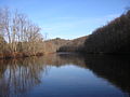
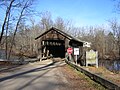
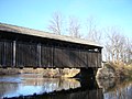
Whites Bridge (alternatively White's Bridge) is a 120-foot (37 m) span Brown truss covered bridge, erected in 1869 in Keene Township, Michigan, United States, near Smyrna on the Flat River. Carrying Whites Bridge Road across the Flat, it is located north of the Fallasburg Bridge and south of Smyrna.
Media in category "Whites Bridge"
The following 9 files are in this category, out of 9 total.
-
 Whites Bridge replica (north approach) 20200524.jpg 4,032 × 3,024; 4.81 MB
-
 WhitesBridge FlatRiver FloorTrussDetail DSCN9961.JPG 1,600 × 1,200; 378 KB
-
 WhitesBridge FlatRiver InteriorTrussDetail DSCN9947.JPG 1,600 × 1,200; 438 KB
-
 WhitesBridge FlatRiver Marker Dscn9971crop.jpg 750 × 1,000; 488 KB
-
 WhitesBridge FlatRiver Scene DSCN9933.JPG 1,600 × 1,200; 359 KB
-
 WhitesBridge FlatRiver SouthEnd DSCN9928.JPG 1,600 × 1,200; 420 KB
-
 WhitesBridge FlatRiver Upstream WholeBridge DSCN9939.JPG 1,600 × 1,200; 436 KB
-
 WhitesBridge FlatRiver UpstreamNorthEnd DSCN9934.JPG 1,600 × 1,200; 380 KB
-
 WhitesBridge FlatRiver UpstreamTruss Dscn9935crop.jpg 1,350 × 960; 835 KB
_20200524.jpg)


Categories:
- Flat River (Michigan)
- Covered bridges in Michigan
- Road bridges in Michigan
- 1860s bridges in Michigan
- Built in Michigan in 1869
- Bridges in the United States completed in 1869
- Destroyed in the United States in 2013
- Destroyed bridges in Michigan
- Bridges in the United States less than 0.1 kilometers
- Michigan State Historic Sites in Ionia County, Michigan
- Bridges over rivers in Michigan