Category:Wilhelminaweg 4, Langbroek
Jump to navigation
Jump to search
| Object location | | View all coordinates using: OpenStreetMap |
|---|
farmhouse in Wijk bij Duurstede, Netherlands  | |||||
| Upload media | |||||
| Instance of | |||||
|---|---|---|---|---|---|
| Location | Langbroek, Utrecht, Netherlands | ||||
| Street address |
| ||||
| Located on street |
| ||||
| Heritage designation |
| ||||
 | |||||
|
This is a category about rijksmonument number 23914
|
| Address |
|
Media in category "Wilhelminaweg 4, Langbroek"
The following 2 files are in this category, out of 2 total.
-
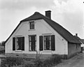 Gevel - Neerlangbroek - 20163091 - RCE.jpg 1,200 × 959; 167 KB
-
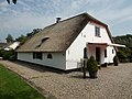 RM23914 Wilhelminaweg 4.JPG 4,320 × 3,240; 2.16 MB
