Category:Wilhelmstraße 7 (Niederbrechen)
Jump to navigation
Jump to search
| Object location | | View all coordinates using: OpenStreetMap |
|---|
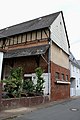
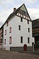
Cultural heritage monument in Niederbrechen, Hesse, Germany  | |||||
| Upload media | |||||
| Instance of | |||||
|---|---|---|---|---|---|
| Location | Niederbrechen, Brechen, Limburg-Weilburg, Giessen Government Region, Hesse, Germany | ||||
| Street address |
| ||||
| Heritage designation | |||||
 | |||||
This is the category of the Hessian Kulturdenkmal (cultural monument) with the ID 50908 (Wikidata)
|
Media in category "Wilhelmstraße 7 (Niederbrechen)"
The following 9 files are in this category, out of 9 total.
-
 Wilhelmstrasse 7 Niederbrechen 01.jpg 3,456 × 5,184; 8.5 MB
-
 Wilhelmstrasse 7 Niederbrechen 02.jpg 3,117 × 4,676; 6.75 MB
-
 Wilhelmstrasse 7 Niederbrechen 03.jpg 3,456 × 5,184; 7.64 MB
-
 Wilhelmstrasse 7 Niederbrechen 04.jpg 3,983 × 3,394; 6.59 MB
-
 Wilhelmstrasse 7 Niederbrechen 05.jpg 3,456 × 5,184; 8.63 MB
-
 Wilhelmstrasse 7 Niederbrechen 06.jpg 3,456 × 5,184; 9.32 MB
-
 Wilhelmstrasse 7 Niederbrechen 07.jpg 3,327 × 4,990; 7.57 MB
-
 Wilhelmstrasse 7 Niederbrechen detail 01.jpg 3,456 × 5,184; 10.49 MB
-
 Wilhelmstrasse 7 Niederbrechen detail 02.jpg 5,184 × 3,456; 10.98 MB


