Category:Willemsplein 43, Arnhem
Jump to navigation
Jump to search
| Object location | | View all coordinates using: OpenStreetMap |
|---|
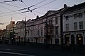
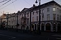
house in Arnhem, Netherlands  | |||||
| Upload media | |||||
| Instance of | |||||
|---|---|---|---|---|---|
| Location | Arnhem, Gelderland, Netherlands | ||||
| Street address |
| ||||
| Heritage designation |
| ||||
 | |||||
|
This is a category about rijksmonument number 8375
|
| Address |
|
Media in category "Willemsplein 43, Arnhem"
The following 7 files are in this category, out of 7 total.
-
 Arnhem - Fromberghuizen 2.JPG 4,608 × 3,456; 3.8 MB
-
 Arnhem - Fromberghuizen-1.jpg 2,592 × 1,728; 1.1 MB
-
 Arnhem - Fromberghuizen.jpg 2,592 × 1,728; 1.18 MB
-
 Arnhem - Willemsplein 43.jpg 1,944 × 2,592; 1.04 MB
-
 Fromberghuizen geheel.jpg 2,592 × 1,728; 1.22 MB
-
 Nice gables at Willemsplein Arnhem 30 November 2013 - panoramio.jpg 4,928 × 3,264; 4.73 MB
-
 Overzicht voorgevels - Arnhem - 20345320 - RCE.jpg 1,188 × 1,200; 355 KB


