Category:Wirksworth
Vai alla navigazione
Vai alla ricerca
town and civil parish in Derbyshire Dales district, Derbyshire, England  | |||||
| Carica un file multimediale | |||||
| Istanza di | |||||
|---|---|---|---|---|---|
| Luogo | Derbyshire Dales, Derbyshire, Midlands Orientali, Inghilterra | ||||
| Popolazione |
| ||||
 | |||||
Sottocategorie
Questa categoria contiene le 8 sottocategorie indicate di seguito, su un totale di 8.
B
H
- Haarlem Mill, Wirksworth (10 F)
N
- National Stone Centre (14 F)
R
- Wirksworth railway station (169 F)
- Ravenstor railway station (9 F)
S
- Steeple Grange Light Railway (15 F)
File nella categoria "Wirksworth"
Questa categoria contiene 200 file, indicati di seguito, su un totale di 456.
(pagina precedente) (pagina successiva)-
 "Standing stone", Wirksworth Moor - geograph.org.uk - 336450.jpg 640 × 480; 113 KB
-
 'At the top of the road, go up the steep steps' - geograph.org.uk - 5108420.jpg 1 024 × 768; 220 KB
-

-
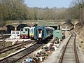
 'Swordfish' approaching - geograph.org.uk - 5814964.jpg 1 024 × 768; 566 KB
-
 'The path now turns right ... across the field' - geograph.org.uk - 5111010.jpg 1 024 × 768; 197 KB
-
 139 miles from London - geograph.org.uk - 2328831.jpg 480 × 640; 79 KB
-
 15 a market place.jpg 2 448 × 3 264; 3,03 MB
-
 180910 Wirksworth 2 (49371952881).jpg 933 × 987; 213 KB
-
 A field with cows - panoramio.jpg 3 106 × 726; 1,77 MB
-
 A is for Aniseed - geograph.org.uk - 3416918.jpg 3 335 × 2 354; 3,06 MB
-
 A March morning in Wirksworth - geograph.org.uk - 3368812.jpg 1 200 × 926; 1,62 MB
-
 A path beside the church - geograph.org.uk - 2686985.jpg 640 × 427; 134 KB
-
 A ruined barn - geograph.org.uk - 6268944.jpg 2 000 × 1 330; 2,38 MB
-
 A stretch of new dry stone wall - geograph.org.uk - 1754788.jpg 640 × 480; 160 KB
-
 A view of Crich Stand War Memorial - geograph.org.uk - 1735641.jpg 640 × 480; 54 KB
-
 A6 south of High Peak Junction - geograph.org.uk - 1810583.jpg 640 × 480; 57 KB
-

-
 Abandoned wagons, Coal Hills Quarry - geograph.org.uk - 2861365.jpg 640 × 425; 216 KB
-
 Across Wirksworth - geograph.org.uk - 3368639.jpg 1 083 × 1 200; 1,62 MB
-
 Adam Bede Plaque - geograph.org.uk - 3672364.jpg 768 × 1 024; 105 KB
-
 Alport height.jpg 640 × 427; 65 KB
-
 An alley to the churchyard - geograph.org.uk - 2682682.jpg 427 × 640; 99 KB
-
 An outbuilding - geograph.org.uk - 2682796.jpg 640 × 427; 125 KB
-
 B5023 into Wirksworth - geograph.org.uk - 3399657.jpg 750 × 563; 172 KB
-
 B5023 towards Wirksworth - geograph.org.uk - 3996932.jpg 640 × 480; 117 KB
-
 B5035 at Godfreyhole.jpg 640 × 480; 100 KB
-
 B5036 Steeple Grange - geograph.org.uk - 5429205.jpg 1 600 × 1 200; 299 KB
-
 Backs of Market Place buildings - geograph.org.uk - 2329497.jpg 1 280 × 959; 450 KB
-
 Bakery and tea room, Wirksworth - geograph.org.uk - 2769033.jpg 1 024 × 772; 352 KB
-
 Barn on Callow lane - geograph.org.uk - 3897642.jpg 3 824 × 2 748; 1,48 MB
-
 Bends ahead - geograph.org.uk - 1045301.jpg 640 × 429; 103 KB
-
 Big Plantation - geograph.org.uk - 1734205.jpg 640 × 480; 108 KB
-
 Black Rock - geograph.org.uk - 1734168.jpg 640 × 480; 138 KB
-
 Black Rock near Wirksworth - geograph.org.uk - 1012298.jpg 640 × 480; 81 KB
-
 Black Rocks - geograph.org.uk - 2349786.jpg 2 048 × 1 536; 1,2 MB
-
 Black Rocks Wirksworth - geograph.org.uk - 5353215.jpg 2 048 × 1 360; 2,03 MB
-
 Blowing off at Wirksworth - geograph.org.uk - 4861960.jpg 640 × 480; 107 KB
-
 Bolehill Road, Bolehill - geograph.org.uk - 5108621.jpg 1 024 × 768; 107 KB
-
 Bowling Green Lane - geograph.org.uk - 3905384.jpg 1 500 × 2 000; 1,33 MB
-
 Breamfield Lane - geograph.org.uk - 968554.jpg 640 × 480; 113 KB
-
 Breamfield Lane - Junction - geograph.org.uk - 968539.jpg 640 × 480; 77 KB
-

-

-
 Breasley Pillows, Water Lane, Wirksworth - geograph.org.uk - 4861920.jpg 640 × 480; 106 KB
-
 Brewery Yard - geograph.org.uk - 2329490.jpg 959 × 1 280; 314 KB
-
 Bridge over the B5023 - geograph.org.uk - 3996935.jpg 640 × 480; 114 KB
-
 Broken down dry stone walls - geograph.org.uk - 321521.jpg 640 × 480; 107 KB
-
 Building on corner of The Causeway and St John's Street - geograph.org.uk - 3904839.jpg 2 000 × 1 386; 656 KB
-
 Business Park on Ravenstor Road - geograph.org.uk - 3266762.jpg 800 × 533; 94 KB
-
 By a corner of Pratthall Lane - geograph.org.uk - 3400203.jpg 750 × 563; 139 KB
-
 By Middle Peak Quarry, Wirksworth - geograph.org.uk - 4563418.jpg 5 028 × 3 691; 4,25 MB
-
 Carrière - panoramio (1).jpg 2 376 × 744; 292 KB
-
 Cemetery near Steeple Grange - geograph.org.uk - 2995850.jpg 640 × 480; 121 KB
-
 Centre of Bolehill near Wirksworth - geograph.org.uk - 6084282.jpg 5 184 × 2 920; 6,12 MB
-
 Chapel Lane, Wirksworth - geograph.org.uk - 936848.jpg 640 × 480; 83 KB
-
 Chapel Lane, Wirksworth, Derbys - geograph.org.uk - 4212550.jpg 3 009 × 4 032; 2,81 MB
-
 Church Close - geograph.org.uk - 3672307.jpg 800 × 600; 131 KB
-
 Church Street, Wirksworth, Derbys - geograph.org.uk - 4211086.jpg 4 032 × 2 558; 2,21 MB
-
 Church Street, Wirksworth, Derbys - geograph.org.uk - 4211195.jpg 4 032 × 3 024; 2,37 MB
-
 Church Street, Wirksworth, Derbys - geograph.org.uk - 4211359.jpg 3 762 × 3 023; 2,38 MB
-
 Church Walk Wirksworth - geograph.org.uk - 488682.jpg 640 × 480; 120 KB
-
 Church Walk, Wirksworth - geograph.org.uk - 2767802.jpg 1 024 × 768; 366 KB
-
 Church Walk, Wirksworth, Derbyshire - geograph.org.uk - 3168964.jpg 1 024 × 768; 212 KB
-
 Churchyard, Wirksworth - geograph.org.uk - 2329205.jpg 640 × 427; 87 KB
-
 Cinder Lane, Wirksworth - geograph.org.uk - 2329503.jpg 1 280 × 959; 422 KB
-
 Climbing frame, Mount Cook Adventure Centre - geograph.org.uk - 5108461.jpg 1 024 × 768; 172 KB
-
 Coach House Dental Practice - geograph.org.uk - 1752237.jpg 640 × 479; 47 KB
-
 Coldwell Street Vicinity, Wirksworth, Derbys - geograph.org.uk - 4212520.jpg 2 804 × 2 864; 1,88 MB
-
 Coldwell Street, Wirksworth, Derbys - geograph.org.uk - 4212602.jpg 3 628 × 2 571; 1,51 MB
-
 Colehill Quarry at The National Stone Centre - geograph.org.uk - 5429215.jpg 1 600 × 1 200; 892 KB
-
 Corner of Wirksworth churchyard - geograph.org.uk - 3919756.jpg 640 × 427; 87 KB
-
 Cottage in The Dale, Wirksworth - geograph.org.uk - 4563436.jpg 3 888 × 5 184; 6,74 MB
-
 Cottages at Wash Green, Wirksworth - geograph.org.uk - 1633117.jpg 473 × 640; 96 KB
-
 Cottages at Washgreen, Wirksworth - geograph.org.uk - 4563524.jpg 3 888 × 5 184; 5,56 MB
-
 Cottages beside St Mary's Church - geograph.org.uk - 3266993.jpg 800 × 533; 117 KB
-
 Cottages by the former railway line - geograph.org.uk - 1734099.jpg 640 × 480; 134 KB
-
 Countryside southeast of Wirksworth, Derbyshire (geograph 150268).jpg 640 × 480; 111 KB
-
 Crag at Middleton - geograph.org.uk - 1522484.jpg 640 × 437; 122 KB
-
 Crinoidal Horizons - geograph.org.uk - 3178427.jpg 800 × 530; 156 KB
-
 Cromford and High Peak Railway - geograph.org.uk - 3178367.jpg 800 × 530; 166 KB
-
 Cromford Road at Bolehill, Wirksworth - geograph.org.uk - 3265729.jpg 4 000 × 2 248; 1,71 MB
-
 Crown Yard, Wirksworth, Derbys - geograph.org.uk - 4212992.jpg 3 076 × 2 787; 1,61 MB
-
 Crown Yard, Wirksworth, Derbys - geograph.org.uk - 4213010.jpg 3 020 × 3 050; 1,99 MB
-
 Cruck Frame - geograph.org.uk - 2326044.jpg 531 × 800; 127 KB
-
 Dale End, Wirksworth - geograph.org.uk - 5916120.jpg 1 024 × 768; 148 KB
-
 Dale End, Wirksworth - geograph.org.uk - 6237765.jpg 1 600 × 900; 622 KB
-

-
 Dark street - panoramio.jpg 2 816 × 2 112; 2,15 MB
-
 Dead and alive, west of Little Bolehill - geograph.org.uk - 5108665.jpg 1 024 × 768; 149 KB
-
 Dene Quarry, by Middleton - geograph.org.uk - 3815701.jpg 4 912 × 3 264; 4 MB
-
 Departing for Ravenstor - geograph.org.uk - 4466641.jpg 640 × 426; 92 KB
-
 Derby Road crosses the Ecclesbourne Valley Railway - geograph.org.uk - 4929426.jpg 2 000 × 1 500; 331 KB
-
 Derby Road, B5023, Wirksworth - geograph.org.uk - 1754802.jpg 640 × 480; 84 KB
-
 Derby Road, Wirksworth, Derbys - geograph.org.uk - 4210027.jpg 4 032 × 2 236; 1,65 MB
-
 Derbyshire UK parish map highlighting Wirksworth.svg 888 × 1 308; 2,34 MB
-
 Derelict building on path to Bolehill - geograph.org.uk - 1184489.jpg 640 × 480; 111 KB
-
 Derelict building on path to Bolehill - geograph.org.uk - 1184496.jpg 640 × 480; 114 KB
-
 Dew pond off the B5035 to Wirksworth - geograph.org.uk - 384483.jpg 640 × 422; 112 KB
-
 Disused Building - geograph.org.uk - 2349797.jpg 2 048 × 1 536; 1,59 MB
-

-

-

-
 East end of West End, Wirksworth - geograph.org.uk - 5916095.jpg 1 024 × 768; 111 KB
-
 Ecclesbourne Valley - geograph.org.uk - 2110225.jpg 640 × 427; 57 KB
-

-

-
 Ecclesbourne Valley Railway - geograph.org.uk - 3996911.jpg 640 × 480; 83 KB
-

-
-
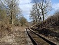 Ecclesbourne Valley railway line - geograph.org.uk - 3399666.jpg 750 × 567; 175 KB
-
 Ecclesbourne Valley Railway's Ravenstor Branch - geograph.org.uk - 5108672.jpg 1 024 × 768; 308 KB
-
 Ecclesbourne Valley Railway, DMU railcar Iris at Wirksworth - geograph.org.uk - 3371637.jpg 4 000 × 3 000; 2,52 MB
-
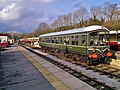
 Ecclesbourne Valley Railway, Wirksworth - geograph.org.uk - 5634554.jpg 640 × 480; 227 KB
-

-
 End of the Line at Ravenstor - geograph.org.uk - 3033710.jpg 1 600 × 1 095; 947 KB
-
 End of The Millennium Wall - geograph.org.uk - 3020048.jpg 1 024 × 683; 310 KB
-
 Entering Wirksworth - geograph.org.uk - 3996913.jpg 640 × 480; 77 KB
-
 Entrance to Bolehill, Oakerthorpe Road - geograph.org.uk - 5108606.jpg 1 024 × 768; 312 KB
-
 Ex Cotton Mill - geograph.org.uk - 2326115.jpg 531 × 800; 108 KB
-
 Eyam Limestones - geograph.org.uk - 3178433.jpg 800 × 530; 117 KB
-
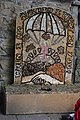 Faded welldressing - 2013 - geograph.org.uk - 3536236.jpg 1 064 × 1 600; 558 KB
-
 Faint field path, east of Broxendale Farm - geograph.org.uk - 5111003.jpg 1 024 × 768; 158 KB
-

-
 Farm buildings at Millers Green - geograph.org.uk - 2893699.jpg 3 648 × 2 736; 4,59 MB
-
 Farmland near Middle Peak Quarry - geograph.org.uk - 360581.jpg 640 × 480; 111 KB
-
 Farmland next to the B5035 - geograph.org.uk - 1196229.jpg 640 × 480; 105 KB
-
 Field above Holehouse Farm - geograph.org.uk - 3400214.jpg 750 × 268; 35 KB
-
 Field by Pratthall Lane - geograph.org.uk - 3400172.jpg 750 × 563; 140 KB
-
 Field by Summer Lane - geograph.org.uk - 3094149.jpg 1 024 × 636; 196 KB
-
 Fields and hedgerows - geograph.org.uk - 2893708.jpg 3 648 × 2 736; 4,85 MB
-
 Fields and view of Wirksworth - geograph.org.uk - 3399678.jpg 750 × 563; 110 KB
-
 Fields below Pratthall Lane - geograph.org.uk - 3400190.jpg 750 × 563; 100 KB
-

-
 Flat Wood, on the Midshires Way, Derbyshire (51599879073).jpg 3 120 × 4 160; 2,77 MB
-
 Fluorite Vug - geograph.org.uk - 3177646.jpg 800 × 530; 134 KB
-
 Fogg's Entry - geograph.org.uk - 2329488.jpg 1 280 × 959; 324 KB
-
 Footpath and Panda - geograph.org.uk - 254486.jpg 640 × 480; 158 KB
-

-
 Footpath in Fields near Gorseybank - geograph.org.uk - 2489284.jpg 3 296 × 2 472; 1,05 MB
-
 Footpath near Flat Wood, Whatfield Farm - geograph.org.uk - 2649552.jpg 640 × 480; 186 KB
-
 Footpath near Stonebridge Farm - geograph.org.uk - 3401121.jpg 750 × 563; 88 KB
-
 Footpath off Chapel Lane - geograph.org.uk - 3905558.jpg 1 464 × 2 000; 1 004 KB
-
 Footpath pointers and post - geograph.org.uk - 1735603.jpg 640 × 480; 76 KB
-
 Former Lead Vein - geograph.org.uk - 3177647.jpg 530 × 800; 151 KB
-
 Former Limestone Quarry - geograph.org.uk - 3178396.jpg 800 × 530; 122 KB
-
 Former Limestone Quarry - geograph.org.uk - 3178402.jpg 800 × 530; 136 KB
-

-
 Former Quarry - geograph.org.uk - 3178373.jpg 640 × 424; 110 KB
-
 Former Reef System - geograph.org.uk - 3177655.jpg 640 × 424; 65 KB
-
 Fossil Reef - geograph.org.uk - 3177366.jpg 800 × 530; 122 KB
-
 Galena (lead ore) - geograph.org.uk - 3177644.jpg 800 × 530; 168 KB
-
 Galena (lead ore) - geograph.org.uk - 3177645.jpg 800 × 530; 149 KB
-
 Gorseybank Crossing - geograph.org.uk - 3002579.jpg 640 × 491; 117 KB
-
 Grazing Land near Wigwell Cottage Farm - geograph.org.uk - 3273991.jpg 4 000 × 3 000; 3,24 MB
-
 Grazing towards Hob Wood - geograph.org.uk - 3996910.jpg 640 × 480; 71 KB
-
 Green Hill - geograph.org.uk - 2682706.jpg 640 × 960; 200 KB
-
 Green Hill - geograph.org.uk - 2682714.jpg 640 × 455; 117 KB
-
 Green Hill, Wirksworth, Derbys - geograph.org.uk - 4212700.jpg 4 032 × 2 601; 1,86 MB
-
 Green Hill, Wirksworth, Derbys - geograph.org.uk - 4212796.jpg 4 032 × 2 986; 2,57 MB
-
 Green Hill, Wirksworth, Derbys - geograph.org.uk - 4212867.jpg 2 909 × 3 692; 2,37 MB
-
 Greenhill - geograph.org.uk - 2328791.jpg 480 × 640; 80 KB
-
 Hammonds Court, Wirksworth - geograph.org.uk - 3094195.jpg 1 024 × 768; 241 KB
-
 Hammonds Court, Wirksworth - geograph.org.uk - 3418050.jpg 3 066 × 3 064; 7,04 MB
-
 Hammonds Court, Wirksworth, Derbyshire - geograph.org.uk - 3164880.jpg 1 024 × 754; 173 KB
-

-
 Harrison Drive, Wirksworth - geograph.org.uk - 5916091.jpg 1 024 × 768; 141 KB
-
 Harrison Drive, Wirksworth, Derbys - geograph.org.uk - 4212881.jpg 2 826 × 4 032; 2,05 MB
-
 Harrison Drive, Wirksworth, Derbys - geograph.org.uk - 4212899.jpg 3 015 × 2 987; 1,79 MB
-
 Hedge with trees - geograph.org.uk - 5610304.jpg 1 280 × 853; 469 KB
-
 High Peak Railway at Steeplehouse Spring 1967 (geograph 2794872).jpg 2 224 × 1 704; 1,22 MB
-

-
 Hillside fields above the B5035 - geograph.org.uk - 3095037.jpg 1 024 × 778; 204 KB
-
 Homesford Cattle Creep - geograph.org.uk - 5245167.jpg 1 280 × 960; 564 KB
-

-
 Homesford Cottage Inn - geograph.org.uk - 2642458.jpg 1 024 × 768; 171 KB
-
 Homesford Single Track Railway - geograph.org.uk - 5454551.jpg 1 600 × 1 200; 755 KB
-
 House with vegetable garden, Wash Green - geograph.org.uk - 4563510.jpg 3 888 × 5 184; 6,22 MB
-
 Houses and hillside south of Wirksworth - geograph.org.uk - 3399750.jpg 750 × 563; 114 KB
-
 Houses in Wirksworth - geograph.org.uk - 2769028.jpg 1 024 × 768; 355 KB
-
 Houses next to Wirksworth Junior School - geograph.org.uk - 5926193.jpg 1 024 × 768; 206 KB
-
 Houses on and above The Dale, Wirksworth - geograph.org.uk - 5108407.jpg 1 024 × 768; 171 KB
-

-
 Houses on West End - geograph.org.uk - 2328803.jpg 640 × 480; 88 KB
-
 Houses stepping up The Lanes, Bolehill - geograph.org.uk - 5108625.jpg 1 024 × 768; 194 KB
-
 Humpback Bridge near Alderwasley College - geograph.org.uk - 3897101.jpg 3 886 × 2 794; 3,02 MB
-
 In the middle of Middle Peak Quarry - geograph.org.uk - 2854495.jpg 4 000 × 3 000; 2,56 MB
-
 Information board - Steeple Grange Light Railway - geograph.org.uk - 5815759.jpg 4 896 × 3 672; 6,73 MB
-

-

-
 Keep the home fires burning! - geograph.org.uk - 375172.jpg 640 × 480; 101 KB
-
 King's Field, Miller's Green, Wirksworth, Derbys - geograph.org.uk - 4209964.jpg 3 748 × 1 977; 1,34 MB
-
 King's Field, Miller's Green, Wirksworth, Derbys - geograph.org.uk - 4209969.jpg 3 707 × 1 678; 1,05 MB
-
 King's Field, Miller's Green, Wirksworth, Derbys - geograph.org.uk - 4209981.jpg 3 424 × 1 976; 1,47 MB
-
 Lane Breamfield Derbyshire.jpg 640 × 480; 109 KB
-
 Lane down to Gorseybank from Hob Hall - geograph.org.uk - 3399716.jpg 750 × 607; 155 KB
-
 Lane Junction at Wash Green - geograph.org.uk - 970012.jpg 640 × 480; 118 KB
-
 Little Bolehill - geograph.org.uk - 5108643.jpg 1 024 × 768; 216 KB
-
 Lodge to Bridge House - geograph.org.uk - 3905576.jpg 1 500 × 2 000; 1,3 MB
-
 Looking along Oakerthorpe Road - geograph.org.uk - 2769048.jpg 1 024 × 706; 351 KB
-
 Looking back on Wirksworth - geograph.org.uk - 1752242.jpg 640 × 480; 68 KB


.jpg)


.jpg)


.jpg)


_-_geograph.org.uk_-_3177644.jpg)
_-_geograph.org.uk_-_3177645.jpg)


_heading_north_out_of_Wirksworth_-_geograph.org.uk_-_5106639.jpg)


.jpg)


.jpg)