Category:Wohnhaus (Obergasse 31–33, Biel/Bienne)
Jump to navigation
Jump to search
| Object location | | View all coordinates using: OpenStreetMap |
|---|
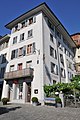
Ensemble of two late medieval houses and the attached "Rotschettenturm" of the former city fortification in Bienne in the canton of Bern, Switzerland  | |||||
| Upload media | |||||
| Instance of | |||||
|---|---|---|---|---|---|
| Part of |
| ||||
| Location | Old Town of Bienne, Biel/Bienne, Biel/Bienne administrative district, Seeland administrative region, Bern, Switzerland | ||||
| Street address |
| ||||
| Heritage designation |
| ||||
| Inception |
| ||||
 | |||||
Media in category "Wohnhaus (Obergasse 31–33, Biel/Bienne)"
The following 3 files are in this category, out of 3 total.
-
 Obergasse 31-33, Biel - Bienne.jpg 2,048 × 2,048; 1.27 MB
-
 Obergasse-33.jpg 1,200 × 1,807; 348 KB
-
 Rotschettenturm, Biel - Bienne.jpg 1,167 × 1,536; 764 KB

