Category:Xobourgo (Tinos)
Jump to navigation
Jump to search
| Object location | | View all coordinates using: OpenStreetMap |
|---|
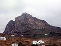
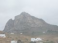
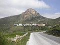
mountain on the island of Tinos  | |||||
| Upload media | |||||
| Instance of | |||||
|---|---|---|---|---|---|
| Location | Tinos, Aegean Sea, Greece | ||||
 | |||||
= Exobourgo or Exomvourgo, refuge place and fortified settlement, from Bronze Age to 18th century AD.
Media in category "Xobourgo (Tinos)"
The following 19 files are in this category, out of 19 total.
-
 "Eine ruhige und authentische Insel". 05.jpg 5,906 × 3,936; 7.14 MB
-
 "Eine ruhige und authentische Insel". 06.jpg 5,906 × 3,858; 5.36 MB
-
 "Eine ruhige und authentische Insel". 07.jpg 5,906 × 3,937; 6.8 MB
-
 Chora of Tinos and Xobourgo from ferry, 090815.jpg 3,227 × 2,151; 3.72 MB
-
 Città, et Castello di Tine - Francesco Basilicata - 1618.jpg 1,500 × 1,100; 845 KB
-
 Exobourgo.jpg 4,000 × 3,000; 3.93 MB
-
 Exomburgotinos levels adjusted.JPG 2,048 × 1,536; 2.1 MB
-
 Exomburgotinos.JPG 2,048 × 1,536; 1.6 MB
-
 Ktikados, Tinos, Greece 2018040510420N00230.jpg 2,272 × 1,704; 812 KB
-
 Loutra, Tinos, Greece 2018040918060N01306.jpg 2,272 × 1,704; 803 KB
-
 Tinos Greece 2018041015560N01927.jpg 2,272 × 1,704; 803 KB
-
 Tinos1.jpg 675 × 544; 325 KB
-
 Tripotamos, Tinos, Greece 2018040618160N00664.jpg 2,272 × 1,704; 709 KB
-
 View of Exomvourgo in Tinos - Dapper Olfert - 1688.jpg 800 × 637; 281 KB
-
 Xinara, Tinos, Greece 2018040913480N01093 01.jpg 2,272 × 1,704; 822 KB
-
 Xinara, Tinos, Greece 2018040913480N01093 02.jpg 2,272 × 1,704; 768 KB
-
 Xobourgo from ferry, Tinos, 090821.jpg 3,359 × 2,239; 3.72 MB
-
 Xobourgo from ferry, Tinos, 090823.jpg 3,471 × 2,311; 4.02 MB
-
 Xobourgo from ferry, Tinos, 224932.jpg 6,048 × 4,024; 8.92 MB


