Category:Yew Tree Farmhouse, Frankby
Jump to navigation
Jump to search
| Object location | | View all coordinates using: OpenStreetMap |
|---|
This is a category about listed building number 1259870. |
Grade II listed farmhouse in Frankby, Merseyside, England, UK  | |||||
| Upload media | |||||
| Instance of | |||||
|---|---|---|---|---|---|
| Location | Frankby, Wirral, Merseyside, North West England, England | ||||
| Heritage designation |
| ||||
 | |||||
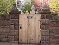
Grade II listed farmhouse, Frankby, Wirral. Its gate piers are also listed separately.
Media in category "Yew Tree Farmhouse, Frankby"
The following 2 files are in this category, out of 2 total.
-
 Gate piers of Yew Tree Farmhouse, Frankby.jpg 4,317 × 3,264; 8.9 MB
-
 Yew Tree farmhouse, Frankby.jpg 4,362 × 3,411; 11.06 MB
