Category:Zeche Graf Bismarck 1/4
Jump to navigation
Jump to search
| Object location | | View all coordinates using: OpenStreetMap |
|---|
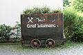
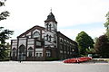
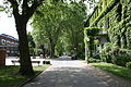
Deutsch: Alle verbliebenen Gebäude der Zeche Graf Bismarck 1/4 sowie einige auf dem alten Betriebsgelände errichtete Neubauten werden derzeit vom Sozialwerk St. Georg genutzt, sind aber von außen frei zugänglich.
Subcategories
This category has the following 2 subcategories, out of 2 total.
Z
Media in category "Zeche Graf Bismarck 1/4"
The following 29 files are in this category, out of 29 total.
-
 Gelsenkirchen - Uechtingstraße - Zeche Graf Bismarck 1-4 01 ies.jpg 2,592 × 3,888; 2.93 MB
-
 Gelsenkirchen - Uechtingstraße - Zeche Graf Bismarck 1-4 02 ies.jpg 3,888 × 2,592; 5.4 MB
-
 Gelsenkirchen - Uechtingstraße - Zeche Graf Bismarck 1-4 03 ies.jpg 3,888 × 2,592; 5.93 MB
-
 Gelsenkirchen - Uechtingstraße - Zeche Graf Bismarck 1-4 04 ies.jpg 3,888 × 2,592; 5.7 MB
-
 Gelsenkirchen - Uechtingstraße - Zeche Graf Bismarck 1-4 05 ies.jpg 3,888 × 2,592; 4.34 MB
-
 Gelsenkirchen - Uechtingstraße - Zeche Graf Bismarck 1-4 06 ies.jpg 3,888 × 2,592; 2.99 MB
-
 Gelsenkirchen - Uechtingstraße - Zeche Graf Bismarck 1-4 07 ies.jpg 3,888 × 2,592; 4.97 MB
-
 Gelsenkirchen - Uechtingstraße - Zeche Graf Bismarck 1-4 08 ies.jpg 2,592 × 3,888; 2.95 MB
-
 Gelsenkirchen - Uechtingstraße - Zeche Graf Bismarck 1-4 09 ies.jpg 3,888 × 2,592; 3.94 MB
-
 Gelsenkirchen - Uechtingstraße - Zeche Graf Bismarck 1-4 10 ies.jpg 3,888 × 2,592; 3.83 MB
-
 Gelsenkirchen - Uechtingstraße - Zeche Graf Bismarck 1-4 11 ies.jpg 3,888 × 2,592; 4.72 MB
-
 Gelsenkirchen - Uechtingstraße - Zeche Graf Bismarck 1-4 12 ies.jpg 3,888 × 2,592; 5.24 MB
-
 Gelsenkirchen - Uechtingstraße - Zeche Graf Bismarck 1-4 13 ies.jpg 3,888 × 2,592; 3.69 MB
-
 Gelsenkirchen - Uechtingstraße - Zeche Graf Bismarck 1-4 14 ies.jpg 3,888 × 2,592; 3.53 MB
-
 Gelsenkirchen - Uechtingstraße - Zeche Graf Bismarck 1-4 15 ies.jpg 3,888 × 2,592; 5.18 MB
-
 Gelsenkirchen - Uechtingstraße - Zeche Graf Bismarck 1-4 16 ies.jpg 3,888 × 2,592; 4.26 MB
-
 Gelsenkirchen - Uechtingstraße - Zeche Graf Bismarck 1-4 17 ies.jpg 3,888 × 2,592; 4.9 MB
-
 Gelsenkirchen - Uechtingstraße - Zeche Graf Bismarck 1-4 18 ies.jpg 3,888 × 2,592; 4.46 MB
-
 Gelsenkirchen - Uechtingstraße - Zeche Graf Bismarck 1-4 19 ies.jpg 3,888 × 2,592; 6.24 MB
-
 Gelsenkirchen - Uechtingstraße - Zeche Graf Bismarck 1-4 20 ies.jpg 3,888 × 2,592; 5.05 MB
-
 Gelsenkirchen - Uechtingstraße - Zeche Graf Bismarck 1-4 21 ies.jpg 3,888 × 2,592; 2.96 MB
-
 Gelsenkirchen - Uechtingstraße - Zeche Graf Bismarck 1-4 22 ies.jpg 3,888 × 2,592; 3.99 MB
-
 Gelsenkirchen - Uechtingstraße - Zeche Graf Bismarck 1-4 23 ies.jpg 3,888 × 2,592; 6.04 MB
-
 Gelsenkirchen - Uechtingstraße - Zeche Graf Bismarck 1-4 24 ies.jpg 3,888 × 2,592; 3.78 MB
-
 Gelsenkirchen - Uechtingstraße - Zeche Graf Bismarck 1-4 25 ies.jpg 3,888 × 2,592; 3.57 MB
-
 Gelsenkirchen - Uechtingstraße - Zeche Graf Bismarck 1-4 26 ies.jpg 3,888 × 2,592; 6.24 MB
-
 Gelsenkirchen - Uechtingstraße - Zeche Graf Bismarck 1-4 27 ies.jpg 5,616 × 3,744; 8.22 MB
-
 Gelsenkirchen - Uechtingstraße - Zeche Graf Bismarck 1-4 28 ies.jpg 5,616 × 3,744; 9.31 MB
-
 Gelsenkirchen - Uechtingstraße - Zeche Graf Bismarck 1-4 29 ies.jpg 5,616 × 3,744; 10.66 MB


