Category:Zeche Walsum
Jump to navigation
Jump to search
| Object location | | View all coordinates using: OpenStreetMap |
|---|
mine  | |||||
| Upload media | |||||
| Instance of | |||||
|---|---|---|---|---|---|
| Location | Duisburg, Düsseldorf Government Region, North Rhine-Westphalia, Germany | ||||
 | |||||
Media in category "Zeche Walsum"
The following 24 files are in this category, out of 24 total.
-
 Bergwerk walsum.jpg 2,592 × 1,944; 1.23 MB
-
-

-

-
-

-

-
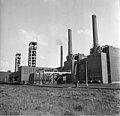
 Bundesarchiv B 145 Bild-F013071-0006, Walsum, Kohlebergbau.jpg 792 × 771; 70 KB
-
 Bundesarchiv B 145 Bild-F013071-0008, Walsum, Kohlebergbau.jpg 794 × 767; 66 KB
-
 Bundesarchiv B 145 Bild-F013073-0002, Walsum, Kohlebergbau.jpg 800 × 744; 105 KB
-
 Bundesarchiv B 145 Bild-F013073-0004, Walsum, Kohlebergbau.jpg 800 × 753; 84 KB
-
 Bundesarchiv B 145 Bild-F013073-0005, Walsum, Kohlebergbau.jpg 793 × 750; 51 KB
-
 Bundesarchiv B 145 Bild-F013075-0001, Walsum, Kohlebergbau.jpg 800 × 772; 102 KB
-
 Bundesarchiv B 145 Bild-F013075-0009, Walsum, Kohlebergbau.jpg 793 × 769; 86 KB
-
 Bundesarchiv B 145 Bild-F013078-0008, Walsum, Kohlebergbau.jpg 800 × 513; 45 KB
-
 Bundesarchiv B 145 Bild-F013078-0014, Walsum, Kohlebergbau.jpg 800 × 508; 51 KB
-
 Bundesarchiv B 145 Bild-F013078-0032, Walsum, Kohlebergbau.jpg 797 × 511; 64 KB
-
 Bundesarchiv B 145 Bild-F015018-0005, Walsum, Kohlebergbau.jpg 800 × 610; 58 KB
-
 Zeche Walsum-Schacht Voerde.jpg 807 × 1,605; 211 KB
-
 Zeche Walsum-Hafenseite.jpg 1,898 × 1,312; 257 KB
-
 Zeche Walsum-headgears.jpg 1,800 × 1,350; 450 KB
-
 Zeche Walsum-Roemerstr.jpg 2,002 × 1,392; 536 KB
-
 Zeche Walsum.JPG 2,560 × 1,920; 2.29 MB
-
 ZecheWalsum01.jpg 4,875 × 3,177; 7.83 MB


Categories:
- Coal mines at the Ruhr by name
- Coal mines in Duisburg
- Route der Industriekultur
- Buildings in Duisburg-Walsum
- Cultural heritage monuments in Duisburg-Alt-Walsum
- RAG Deutsche Steinkohle AG
- 1927 establishments in Duisburg
- Mines in North Rhine-Westphalia opened in 1927
- Mines in North Rhine-Westphalia closed in 2008