Commons:Wikimaps
Jump to navigation
Jump to search
| Wikimaps | Future | Design | Participants | Resources | GLAM model |
New! Join the Wikimaps User Group
Wikimaps is a project where wikimedians work together with GLAMS (Galleries, Libraries, Archives and Museums) to collect old maps in Wikimedia Commons. The project offers an emerging collection of tools to work with historical maps and imagery. Wikimaps Warper is a tool for georeferencing old maps via crowdsourcing, and make them available for historical mapping in the OpenHistoricalMap project. The information gathered from the maps will contribute to a historical gazetteer, a place name index across times. There is a WikiProject in Wikidata to model this together, the WikiProject Historical Place.
Objectives[edit]
- WORK with GLAMs (Galleries, Libraries, Archives and Museums) to bring high quality historical maps to Wikimedia Commons
- COMBINE existing Wikimedia components to create a maps environment (Wikimedia Commons, Structured Data on Commons, Wikidata, OSM integration, upload tools)
- LOCATE and further develop missing open source tools (georeferencing...)
- ESTABLISH the Wikimaps community
- CONNECT with experts, enthusiasts and other open data actors
- CREATE models for cartographic GLAM cooperation (scanning, events, uploads...)
- DESIGN necessary user interfaces (map selection, time sliders, embedding, layer visibility...)
- INTEGRATE Linked Open Data efforts into this to the extent possible (spatiotemporal ontologies...)
- COORDINATE the creation & display of historical geodata with other actors
The 6 goals of the Wikimaps environment[edit]
- Mass map upload tools for institutions
- We collaborate with the team that develops the GLAM-wiki tool for image mass upload to the Wikimedia Commons, organized by the Central European Wikimedia chapters and Europeana together. Our aim is to ensure that all necessary metadata is transferred along with the map images. We also work to define the required metadata for maps. We develop ways to collaborate with GLAMs and gather experiences.
- Adding geolocation to maps in Commons
- In the initial phase of the project we produce a tool to georeference maps in the Wikimedia Commons. The tool that we use has been developed for the New York Public Library and the Library of Congress. We modify it together with the original developer to suit the need of Wikimedia Commons.
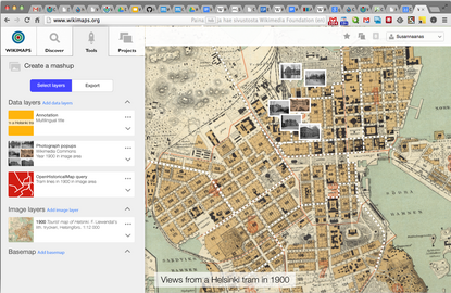
- Web mapping service in Wikimedia
- When the maps have been georeferenced, they can be searched by location and viewed together with other map layers. Parts of the map service include a dedicated tileserver for Wikimedia and open source software solutions to allow smooth viewing of maps.
- Collaboratively vectorizing old maps
- Open Historical Map is a project within OpenStreetMap, where vectorized geodata is produced based on old maps. OpenStreetMap has several tools for producing, storing and displaying maps. We hope to join forces with the project for the projects to benefit one another.
- Spatiotemporal gazetteer in Wikidata
- A spatiotemporal gazetteer is a repository of place names with a temporal dimension. The information can on one hand be gathered in the process of vectorization. On the other hand we connect with researchers and institutions working with gazetteers to find ways in which they can be connected with each other and stored. In our mind Wikidata could be a preferable choice for interconnecting them.
- Map mashup tools in Wikimedia
- The work will enable an environment where map imagery and information can be enhanced with external data with the help of new visualization tools. The map visualizations with animations and interactivity can be presented in Wikipedia and elsewhere.
Introduction to the workflow[edit]
Upload maps[edit]
- Mass maps uploads can be made with the GLAM-Wiki Toolset or GLAMpipe, a new tool by WMFI. They will apply the Map template to the uploaded files.
- Individual maps can be uploaded with the Upload Wizard, but then the Map template needs to be added manually.
Categorize maps[edit]
- Old maps are categorized in Old maps categories
- Inside these categories, if you have a map with several sheets, move them into a subcategory. This will allow you to import them to Wikimaps Warper all at once, see later.
Add the Map template manually and edit metadata[edit]
- Change the {{Information}} template to the {{Map}} template.
- A mass search and replace operation can be made with the VisualFileChange tool.
- After the template name has been changed, use Visual Editor to edit the metadata. It can guide in proposing the fields to fill in.
- Currently the parameter "warped" must be set to anything other than empty. This is going to become unnecessary in the next update of the Map template.
Send the map to the Warper[edit]
- Locate a big blue button in the file page. This will let you view the map in the Wikimaps Warper or send it there depending on if it already has been imported.
- In the Warper you can either set up a user account or you can use OAuth to login with your Wikimedia, OpenStreetMap or GitHub user account.
Rectify the old map[edit]
- Use the Rectify tab to place control points in the old map and the corresponding location in a current map.
- Use the Crop tab to mask unwanted edges or legend areas from view. This will not alter the image and you can at any time remove the mask. The image in Commons remains intact.
- Use the Preview tab to see the map overlaid on the reference map.
- Use the Export page to save the resulting map in several formats, or get a link to access it as tiles.
- Use the Trace tab to enter the iD editor for OpenHistoricalMap. Digitize features on the old map and add them to the OHM database.
Import/export control points to a map to/from another system[edit]
- In Wikimaps Warper under the Rectify tab, open Control point settings.
- To export the control points, click on Download points as CSV
- To import points, prepare a csv file with a header and columns: x,y,lon,lat, where x and y are image pixel coordinates, and lat and lon are the position in the Mercator coordinate system
- Upload it by choosing the file in CSV File with Control Points
Mass import maps to Wikimaps Warper[edit]
- Request a permission for mass imports in ___
- In Wikimaps Warper in the Imports page click Add new import under Imports from Wiki Category
- Input the category name including the namespace prefix (Category:<Category name>)
- Tick Save maps to a new or existing mosaic to create a view that includes all the maps from that category. This is useful for maps that have several sheets. Similarly, it is useful to categorize maps with several sheets into a single category.
Batch import of control points[edit]
- Request a permission for mass imports in ___
- In Wikimaps Warper in the Imports page click Import CSV under Bulk Gound Control CSV Import
- Prepare a csv file with a header and columns: mapid,pageid,x,y,lon,lat, where mapid is the map id in Wikimaps Warper, pageid is the page id of the file in Wikimedia Commons, x and y are image pixel coordinates, and lat and lon are the position in the Mercator coordinate system. Mapid and pageid are alternatives, you only need one or the other. If you provide both mapid and pageid, the import will use mapid.
How to contribute[edit]
- Categorize maps
- Add map templates
- Test the workflow
- Propose features and enhancements
- Join the discussion in the Wikimaps Facebook group.
- Follow the Wikimaps blog.
Work with GLAMs[edit]
- Talk to maps libraries and archives, ask them to open their maps collection.
- Familiarize with the GLAMpipe tool, and any other mass upload tools or get in contact with skilled Wikimedians.
- Document your work and share it. Blog about it in the Wikimaps blog!
Work with volunteers[edit]
- Find groups that share an interest in historical location: genealogists, hackers, geographers, mappers...
- Find out how the tools work, and what does not work. What do your volunteers need?
- Propose features and enhancements or grab a task yourself
- Document your work and share it, even if you did not use the tools or manage to add information to Wikimedia. Blog about it in the Wikimaps blog!
If you are into Wikidata[edit]
- Participate in discussion about map properties in Wikidata
- Participate in the discussion about modeling historical places in Wikidata
- Think how to use Wikidata, how to transition the Map template to use Wikidata
- Think how to transfer maps data to Wikidata, and which maps will be ok to include in WIkidata.
If you can code[edit]
- Think how to find maps. What is the best search environment for maps in Wikimedia?
- Think how to use Wikidata, how to transition the Map template to use Wikidata
- Think how the maps could be used in articles. What technology are we lacking?
- Think how the warped map could appear on the file page, in the Media viewer, on the category page and how to access the tools from those locations.
- You can contribute to the Warper, the Map template or the Wikimaps front end codebases at GitHub.
Imagine further[edit]
- How do location, articles, maps, images and documents relate to each other?
- What use cases are there for mashing up historical documents?
- What does it look like, where does it happen?
- Share your scenarios
Timeline[edit]
-
 Historical maps workshop
Second Swiss Open Cultural Heritage Data Hackathon, 1-2 July 2016, Basel, CH -
 Wikimaps workshop in Wikimania
 -
-
 Wikimaps Warper 2.0 Individual Engagement Grant
 -
 Wikimaps Warper new features: Category import of maps
 -
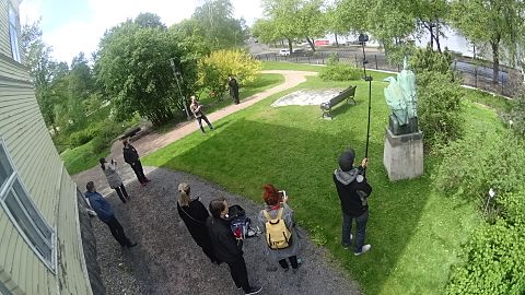 DroneArt Helsinki!
Workshop of 3D imaging public artworks, in collaboration with Maptime Helsinki and AvoinGLAM, Helsinki June 2015


- Participation in DH2016 workshop: Beyond Basics - What next for crowdsourcing?
- WikiProject Historical Place
- MapWarper enhancements: Control points csv mass import, Wikimedia Commons category import
- Mockups and demos for future development: Wikimaps site, map search, OHM integration
- Joint efforts for Finnish historical map series with Linked Data Finland
- GLAMpipe mass upload and metadata refining tool project, Wikimedia Suomi
- Mobilizing Open Cultural Data by Wikimedia Suomi. One topic is historical place names and maps.
- NordLOD, Stockholm, September 2015. Focus on Wikidata and maps.
- #Hack4NO, participation in hackathon organized by Kartverket, Norway: Map uploads
- Wikimaps presentation and participation in the Digital Humanities Hackathon at Helsinki University
- Wikimaps goes Maptime in GLAM-Wiki in Den Haag
- Wiki Loves Maps seminar and hackathon, Helsinki
- State of the Map, Buenos Aires 7–9 November, 2014. Presentation and a mini workshop.
- Enhancement of the Wikimaps Warper: OAuth, integration of OpenHistoricalMap editor, Warper code revision
- Wikimania hackathon https://wikimania2014.wikimedia.org/wiki/Hackathon, London 6–10 August
- DH2014 Digital Humanities 2014 http://dh2014.org/ 8-12 July 2014 Lausanne, Swtzerland Inaugural meeting of GeoHumanities SIG. Wikimaps presentation and position paper.
- Third Digital Humanities Finland Symposium (#digihumfi) Symposium, Thursday 5 June 2014, 10:00-13:00, Fabiania Auditorium, National Library of Finland, Helsinki, http://matsfridlund.com/digital-humanities-finland/, Wikimaps presentation
- Wiki Loves Maps Expert Meeting in Amsterdam, arranged by the Dutch chapter. See the project page.
- Wikimedia Hackathon, Zürich, 9-11 May 2014 concentrating on maps. The event page and the Wikimaps blog post
- Wikimaps supports OpenHistoricalMap server maintenance.
- Wikimaps and OpenHistoricalMap mentor a Wikimedia Foundation supported FOSS OPW intern together.
- Wikimaps Nordic Kick-off workshop, 28 February 2014. See blog post and the event page at Lanyrd.
- Related academic visit through COST ENERGIC STSM in Oxford Internet Institute at the University of Oxford and Extreme Citizen Science Research Group at the University College of London, 13–24 January, 2014. Read the Wikimaps blog post.
- Monthly Wikimaps Hangouts in 2014 for 2 groups: The Wikimaps Nordic and the Designers & Developers. The documentation is at the Wikimaps events page.
- Wikipedia Academy, Oslo, Norway, 14 December 2013. Presentation.
- Getting organized through an online /Wikimaps planning meeting, 3 December 2013.
- Wikimaps Nordic project gets funding from the Nordic Culture Fund
- State of the Map, Birmingham, UK, from 6 September 2013 until 8 September 2013. Presentation by Susanna Ånäs. Birds-of-a-feather meeting with OHM.
- The National Archives of Finland hosts a local meeting for open cartography enthusiasts, 26 August 2013.
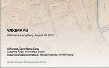
- Wikimaps Tartu–Hong Kong. Series of events where maps of Tartu were taken through the Wikimaps process. Workshop in Tartu – DevCamp in Wikimania. Presentation slides.
- 4 August 2013 Workshop for Tartu maps, Tartu, Estonia. State of the Map Baltics from 3 August 2013 until 4 August 2013.
- 7 August 2013 Wikimania DevCamp, Wikimaps geodata round table
- 10 August 2013 Presentation at Wikimania 2013, Hong Kong by Susanna Ånäs & Maarten Dammers. Cooperation with Open Historical Map Code Sprint.
- from 30 June 2013 until 5 July 2013 The 25th International Conference on the History of Cartography Helsinki, Finland
- 29 June 2013 Meeting of ISCEM, International Society of Curators of Early Maps, related to the conference. Susanna presents Wikimaps. Presentation slides
- Historical OpenStreetMaps group is interested in collaboration (http://wiki.openstreetmap.org/wiki/OHM, http://www.openhistoricalmap.org/).
- from 24 May 2013 until 26 May 2013 The Amsterdam Hackathon. Requirements, Resources and Participants started. memo
- 13 April 2013 Susanna Ånäs from Wikimedia Suomi introduces the initiative to the international Wikimedia GLAM community in GLAM-Wiki in London. Presentation slides
Participation[edit]
- Participants List your name on the participant list if you want to participate. We welcome developers, GIS experts, designers, historian, GLAMs and others to participate in the work and discussion. Please let us know if you are available for consultation, even if you do not want to work.
- Requirements Discuss requirements and scenarios for a maps environment.
- Development The work process will be described here.
- Resources Participate in charting historical maps resources: projects and tools, that are related with the scope of this plan.
- Model for GLAM participation Participate in creating a model for cartographic GLAM cooperation.
- Other Page m:Wikimaps should be reviewed for outdated information and conflicts.
Communication[edit]
- Wikimaps blog http://wikimaps.wikimedia.fi/
- Facebook page https://www.facebook.com/groups/wikimaps
- Wikimaps Trello boards https://trello.com/wikimaps
- maps-l@lists.wikimedia.org (Wikimedia) Info: https://lists.wikimedia.org/mailman/listinfo/maps-l
- Historic@openstreetmap.org (OSM) Info: http://lists.openstreetmap.org/listinfo/historic
- Twitter hashtag #wikimaps
See also[edit]
- Wikimaps presentation at Wikimania 2013 in SlideShare
- A blog post on the Wikimaps Tartu–Hong Kong project by Wikimedia Finland
- Blog post by SK53 OSM on the workshop in Tartu
- Earlier proposal by Maarten Dammers for Wikimaps
- The Finnish Historical maps project Wikiprojekti Historialliset kartat
- http://wiki.openstreetmap.org/wiki/OHM