File:1650 Fuller Map of Jerusalem ( Israel, Palestine, Holy Land) - Geographicus - jerusalem-fuller-1650.jpg
Jump to navigation
Jump to search

Size of this preview: 783 × 600 pixels. Other resolutions: 313 × 240 pixels | 627 × 480 pixels | 1,003 × 768 pixels | 1,280 × 980 pixels | 2,560 × 1,961 pixels | 4,000 × 3,064 pixels.
Original file (4,000 × 3,064 pixels, file size: 4.28 MB, MIME type: image/jpeg)
Captions
Captions
Add a one-line explanation of what this file represents
| IERUSALEM qualis (ut plurimum) extitit ætate Solomonis | ||||||
|---|---|---|---|---|---|---|
| Artist | ||||||
| Title |
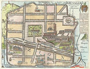
IERUSALEM qualis (ut plurimum) extitit ætate Solomonis |
|||||
| Description |
English: An extremely rare and altogether fascinating 1650 map of Jerusalem by Thomas Fuller. Depicts the old walled city of Jerusalem during the reign of the Biblical King Solomon, ca. 961-922 BC. On the whole this is a highly imaginative map of the city and likely bears no significant resemblance to the Jerusalem of Solomon. Solomon's Temple appears at the right center with a tall bell tower and a highly Renaissance European design aesthetic. At the center, roughly where the Church of Holy Sepulture is located today, is Solomon's menagerie. The Baths of Bethesda, in which an angel swims, appear in the upper right, approximately where they are said to be today. Other sites of note include Domus David near the modern day Jaffa Gate, the armory in the lower left, the Kings House at bottom center, Solomon's throne near the menagerie at center, the golden gate at right center, etc. Throughout the streets are arranged with an uncanny geometric precisions. Outside the walls Fuller identifies the Mount of Olives (Montis Oliueti), the Dragon Well, the Fullers Field, the King's Garden, and despite purportedly being a map of Solomon's Jerusalem, the Crucifixion on Calvary. A armorial crest and a dedication to Eduardo Montagu, or Edward Montagu, the First Earl of Sandwich, appears in the upper right quadrant. Engraved by John Williams for the 1650 first edition of Thomas Fuller's A Pisgah-sight of Palestine . This map is exceptionally rare and an important addition to any serious Israel - Palestine - Holy Land collection. We have found no record of it appearing on the market in the last 10 years. |
|||||
| Date | 1665 (undated) | |||||
| Dimensions | height: 11.5 in (29.2 cm); width: 15 in (38.1 cm) | |||||
| Accession number |
Geographicus link: jerusalem-fuller-1650 |
|||||
| Source/Photographer |
Fuller, Thomas, Pisgah-Sight Of Palestine And The Confines Thereof, With The History of the Old and New Testament acted thereon., 1650.
|
|||||
| Permission (Reusing this file) |
|
|||||
File history
Click on a date/time to view the file as it appeared at that time.
| Date/Time | Thumbnail | Dimensions | User | Comment | |
|---|---|---|---|---|---|
| current | 08:30, 23 March 2011 | | 4,000 × 3,064 (4.28 MB) | BotMultichillT (talk | contribs) | {{subst:User:Multichill/Geographicus |link=http://www.geographicus.com/P/AntiqueMap/jerusalem-fuller-1650 |product_name=1650 Fuller Map of Jerusalem ( Israel, Palestine, Holy Land) |map_title=IERUSALEM qualis (ut plurimum) extitit ætate Solomonis |descri |
You cannot overwrite this file.
File usage on Commons
The following page uses this file:
_-_Geographicus_-_jerusalem-fuller-1650.jpg)
File usage on other wikis
The following other wikis use this file:
- Usage on fr.wikipedia.org
- Usage on he.wikipedia.org
_-_Geographicus_-_jerusalem-fuller-1650.jpg&oldid=823952866)