File:1775 Mannevillette Map of Trincomalee, Ceylon or Sri Lanka - Geographicus - TrinquemalayCeylon-mannevillette-1775.jpg
Jump to navigation
Jump to search

Size of this preview: 800 × 595 pixels. Other resolutions: 320 × 238 pixels | 640 × 476 pixels | 1,024 × 762 pixels | 1,280 × 952 pixels | 2,560 × 1,905 pixels | 5,000 × 3,720 pixels.
Original file (5,000 × 3,720 pixels, file size: 4.49 MB, MIME type: image/jpeg)
Captions
Captions
Add a one-line explanation of what this file represents
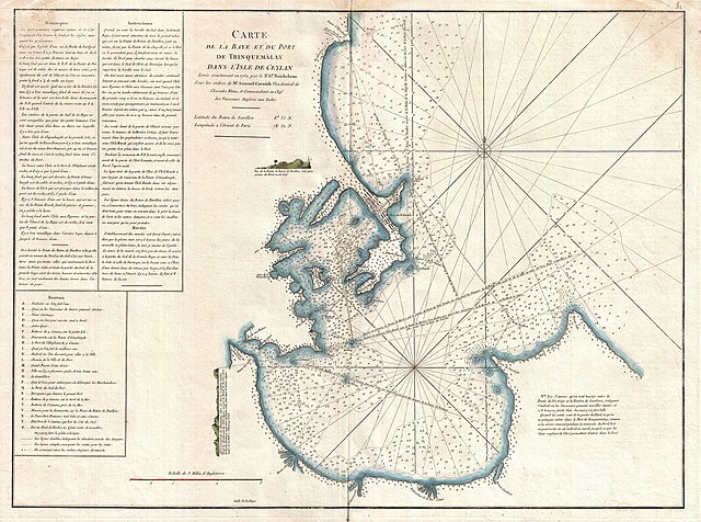
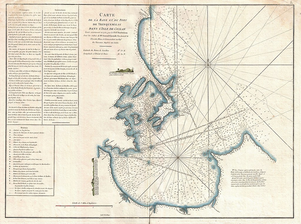
| Carte de la Baye et du Port de Trinquemalay dans L'Isle de Ceylan. | ||||||
|---|---|---|---|---|---|---|
| Artist | ||||||
| Title |
Carte de la Baye et du Port de Trinquemalay dans L'Isle de Ceylan. |
|||||
| Description |
English: An extremely attractive large format 1775 maritime map or nautical chart of the port of Trincomalee, Ceylon (Sri Lanka) by Jean-Baptiste d'Après de Mannevillette. Trincomalee is natural deep water port on the east coast of Sri Lanka, about 110 miles northeast of Kandy. It is one of the main centers of Tamil speaking culture in Ceylon. Historically referred to as Gokanna or Gokarna it has been a sea port that has played a major role in maritime and international trading history of Sri Lanka. Throughout its long history Trincomalee has been an important and strategic port various colonial powers including the Portuguese, Dutch, French and British. Inland detail in minimalist but marine detail is excellent with well-defined coastlines, many rhumb lines, numerous harbors and ports noted, and countless depth soundings. Detailed sailing instructions fill the upper left quadrant. Mannevillette’s chart marks a considerable advancement over previous nautical maps of this region. Engraved by De La Haye for Jean-Baptiste d'Après de Mannevillette’s 1775 Neptune Oriental . |
|||||
| Date | 1762 (dated, though published in 1775) | |||||
| Dimensions | height: 20 in (50.8 cm); width: 27 in (68.5 cm) | |||||
| Accession number |
Geographicus link: TrinquemalayCeylon-mannevillette-1775 |
|||||
| Source/Photographer |
Mannevillette, D'Apres de, Le Neptune Oriental, 1775.
|
|||||
| Permission (Reusing this file) |
|
|||||
File history
Click on a date/time to view the file as it appeared at that time.
| Date/Time | Thumbnail | Dimensions | User | Comment | |
|---|---|---|---|---|---|
| current | 04:04, 25 March 2011 | | 5,000 × 3,720 (4.49 MB) | BotMultichillT (talk | contribs) | {{subst:User:Multichill/Geographicus |link=http://www.geographicus.com/P/AntiqueMap/TrinquemalayCeylon-mannevillette-1775 |product_name=1775 Mannevillette Map of Trincomalee, Ceylon or Sri Lanka |map_title=Carte de la Baye et du Port de Trinquemalay dans |
You cannot overwrite this file.
File usage on Commons
The following page uses this file:
File usage on other wikis
The following other wikis use this file:
- Usage on bn.wikipedia.org
- Usage on en.wikipedia.org
- Usage on si.wikipedia.org