File:Greatbasinmap.png
Jump to navigation
Jump to search

Size of this preview: 536 × 599 pixels. Other resolutions: 215 × 240 pixels | 430 × 480 pixels | 687 × 768 pixels | 916 × 1,024 pixels | 1,500 × 1,676 pixels.
Original file (1,500 × 1,676 pixels, file size: 7.21 MB, MIME type: image/png)
Captions
Captions
Add a one-line explanation of what this file represents
Summary
[edit]
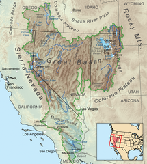
| Description | Map showing the Great Basin drainage basin as defined hydrologically. |
| Date | |
| Source | Own work, Elevation data from SRTM, all other features from the National Atlas. Rand McNally, The New International Atlas, 1993 used as reference. |
| Author | Kmusser |
| Other versions |
 |
Licensing
[edit]
I, the copyright holder of this work, hereby publish it under the following license:
This file is licensed under the Creative Commons Attribution-Share Alike 3.0 Unported license.
- You are free:
- to share – to copy, distribute and transmit the work
- to remix – to adapt the work
- Under the following conditions:
- attribution – You must give appropriate credit, provide a link to the license, and indicate if changes were made. You may do so in any reasonable manner, but not in any way that suggests the licensor endorses you or your use.
- share alike – If you remix, transform, or build upon the material, you must distribute your contributions under the same or compatible license as the original.
File history
Click on a date/time to view the file as it appeared at that time.
| Date/Time | Thumbnail | Dimensions | User | Comment | |
|---|---|---|---|---|---|
| current | 22:25, 4 September 2020 | | 1,500 × 1,676 (7.21 MB) | Nwbeeson (talk | contribs) | Added boundary map. Second attempt to upload the image. |
| 22:21, 4 September 2020 |  | 1,500 × 1,676 (7.21 MB) | Nwbeeson (talk | contribs) | Added boundary line. | |
| 16:58, 11 December 2010 |  | 1,500 × 1,676 (3.64 MB) | Kmusser (talk | contribs) | Added Goose Lake | |
| 20:37, 17 November 2010 |  | 1,500 × 1,676 (3.23 MB) | Kmusser (talk | contribs) | == Summary == {{Information |Description=Map showing the Great Basin drainage basin as defined hydrologically. |Source={{own}}, Elevation data from SRTM, all other features from the [[:w:National |
You cannot overwrite this file.
File usage on Commons
The following page uses this file:
File usage on other wikis
The following other wikis use this file:
- Usage on ar.wikipedia.org
- Usage on ast.wikipedia.org
- Usage on az.wikipedia.org
- Usage on bg.wikipedia.org
- Usage on bn.wikipedia.org
- Usage on bs.wikipedia.org
- Usage on ckb.wikipedia.org
- Usage on cs.wikipedia.org
- Usage on de.wikipedia.org
- Usage on es.wikipedia.org
- Usage on et.wikipedia.org
- Usage on fa.wikipedia.org
- Usage on fi.wikipedia.org
- Usage on fr.wikipedia.org
- Usage on fy.wikipedia.org
- Usage on he.wikipedia.org
- Usage on id.wikipedia.org
- Usage on is.wikipedia.org
- Usage on it.wikipedia.org
- Usage on ja.wikipedia.org
- Usage on ka.wikipedia.org
- Usage on kk.wikipedia.org
- Usage on kn.wikipedia.org
- Usage on ko.wikipedia.org
- Usage on lfn.wikipedia.org
- Usage on li.wikipedia.org
- Usage on lt.wikipedia.org
- Usage on mk.wikipedia.org
- Usage on ml.wikipedia.org
- Usage on mr.wikipedia.org
- Usage on nl.wikipedia.org
- Usage on nn.wikipedia.org
- Usage on pa.wikipedia.org
- Usage on pl.wikipedia.org
- Usage on pnb.wikipedia.org
- Usage on pt.wikipedia.org
- Usage on ru.wikipedia.org
- Usage on simple.wikipedia.org
- Usage on sq.wikipedia.org
- Usage on sw.wikipedia.org
- Usage on ta.wikipedia.org
- Usage on tr.wikipedia.org
- Usage on uk.wikipedia.org
- Usage on uz.wikipedia.org
View more global usage of this file.