File:Karte Verlauf Rennsteig.png
Jump to navigation
Jump to search

Size of this preview: 800 × 555 pixels. Other resolutions: 320 × 222 pixels | 640 × 444 pixels | 1,024 × 710 pixels | 1,280 × 887 pixels | 1,500 × 1,040 pixels.
Original file (1,500 × 1,040 pixels, file size: 2.5 MB, MIME type: image/png)
Captions
Captions
Add a one-line explanation of what this file represents
| Description |
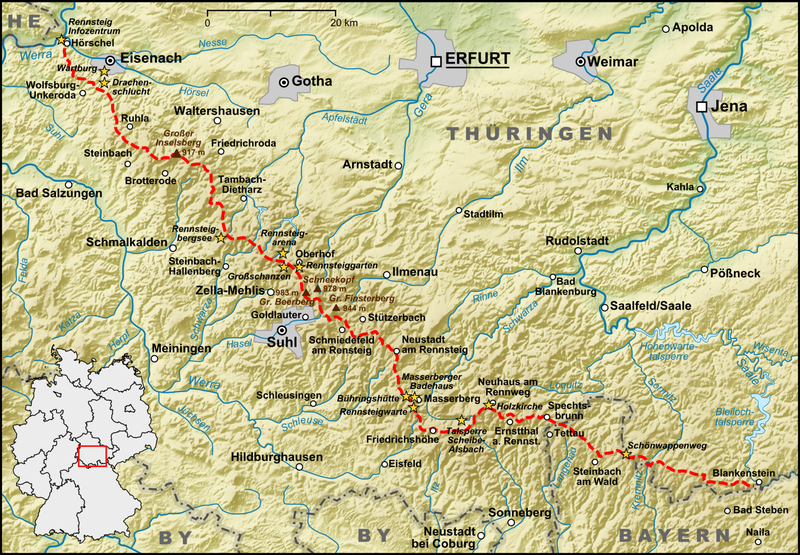
en: Course of the Rennsteig in the Thuringian Forest, Germany |
| Date | |
| Source |
Own work, used:
|
| Author | Lencer |

|
This map has been made or improved in the German Kartenwerkstatt (Map Lab). You can propose maps to improve as well.
|
The map has been created with the Generic Mapping Tools: https://www.generic-mapping-tools.org/ using one or more of these public-domain datasets for the relief:
|

|
Permission is granted to copy, distribute and/or modify this document under the terms of the GNU Free Documentation License, Version 1.2 or any later version published by the Free Software Foundation; with no Invariant Sections, no Front-Cover Texts, and no Back-Cover Texts. A copy of the license is included in the section entitled GNU Free Documentation License. |
File history
Click on a date/time to view the file as it appeared at that time.
| Date/Time | Thumbnail | Dimensions | User | Comment | |
|---|---|---|---|---|---|
| current | 13:21, 7 April 2014 | | 1,500 × 1,040 (2.5 MB) | Kopiersperre (talk | contribs) | optipng |
| 13:02, 10 September 2009 |  | 1,500 × 1,040 (2.65 MB) | Lencer (talk | contribs) | {{Information| |Description={{de|Karte des Verlaufs des Rennsteigs im Thüringer Wald}} |Source={{Own}}, used: * Generic Mapping Tools and SRTM3 V2-files for relief * OpenStreetMap * |
You cannot overwrite this file.
File usage on Commons
There are no pages that use this file.
File usage on other wikis
The following other wikis use this file:
- Usage on de.wikipedia.org
- Usage on de.wikibooks.org
- Usage on en.wikipedia.org
- Usage on eo.wikipedia.org
- Usage on es.wikipedia.org
- Usage on fr.wikipedia.org
- Usage on incubator.wikimedia.org
- Usage on it.wikipedia.org
- Usage on la.wikipedia.org
- Usage on nl.wikipedia.org
- Usage on pl.wikivoyage.org
- Usage on ru.wikipedia.org
- Usage on uk.wikipedia.org