File:Kroatien - Politische Gliederung (Karte).png
Jump to navigation
Jump to search

Size of this preview: 748 × 599 pixels. Other resolutions: 300 × 240 pixels | 599 × 480 pixels | 958 × 768 pixels | 1,278 × 1,024 pixels | 1,460 × 1,170 pixels.
Original file (1,460 × 1,170 pixels, file size: 363 KB, MIME type: image/png)
Captions
Captions
Add a one-line explanation of what this file represents
| Description |
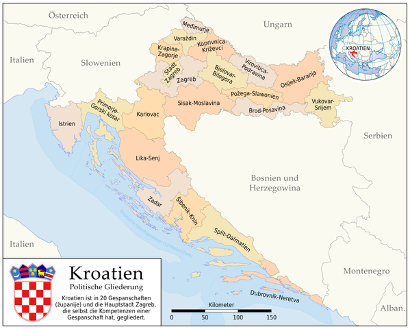
Deutsch: Karte der politischen Gliederung von Kroatien auf Ebene der županije
English: Map of the administrative divisions of Croatia on županije level |
|
| Date | ||
| Source |
Self made, using
|
|
| Author | Maximilian Dörrbecker (Chumwa) | |
| Permission (Reusing this file) |
I, the copyright holder of this work, hereby publish it under the following license: This file is licensed under the Creative Commons Attribution-Share Alike 2.5 Generic license.
Sie dürfen das Bild zu den folgenden Bedingungen nutzen:
|
|
| Other versions |
|
.png)
.svg)
File history
Click on a date/time to view the file as it appeared at that time.
| Date/Time | Thumbnail | Dimensions | User | Comment | |
|---|---|---|---|---|---|
| current | 06:21, 29 June 2008 | | 1,460 × 1,170 (363 KB) | Chumwa (talk | contribs) | typo |
| 05:05, 14 May 2008 |  | 1,460 × 1,170 (363 KB) | Chumwa (talk | contribs) | diverse Ergänzungswünsche eingearbeitet | |
| 21:42, 12 May 2008 |  | 1,460 × 1,170 (299 KB) | Chumwa (talk | contribs) | {{Information |Description= *{{ de }} Karte der politischen Gliederung von Kroatien auf Ebene der županije *{{ en }} Mop of the administrative divisions of Croatia on županije level |Source=Self made, using * [[:Image:Croatia_map_municipalities.gif|Base |
You cannot overwrite this file.
File usage on Commons
The following 6 pages use this file:
File usage on other wikis
The following other wikis use this file:
- Usage on azb.wikipedia.org
- Usage on de.wikipedia.org
- Usage on frr.wikipedia.org
- Usage on gag.wikipedia.org
- Usage on ps.wikipedia.org
- Usage on rm.wikipedia.org
- Usage on sv.wikipedia.org
.png&oldid=698266691)