File:Ottoman Empire 16-17th century-fr.svg
Jump to navigation
Jump to search

Size of this PNG preview of this SVG file: 800 × 585 pixels. Other resolutions: 320 × 234 pixels | 640 × 468 pixels | 1,024 × 749 pixels | 1,280 × 936 pixels | 2,560 × 1,872 pixels.
Original file (SVG file, nominally 800 × 585 pixels, file size: 978 KB)
Captions
Captions
Add a one-line explanation of what this file represents
Summary[edit]
| Description |
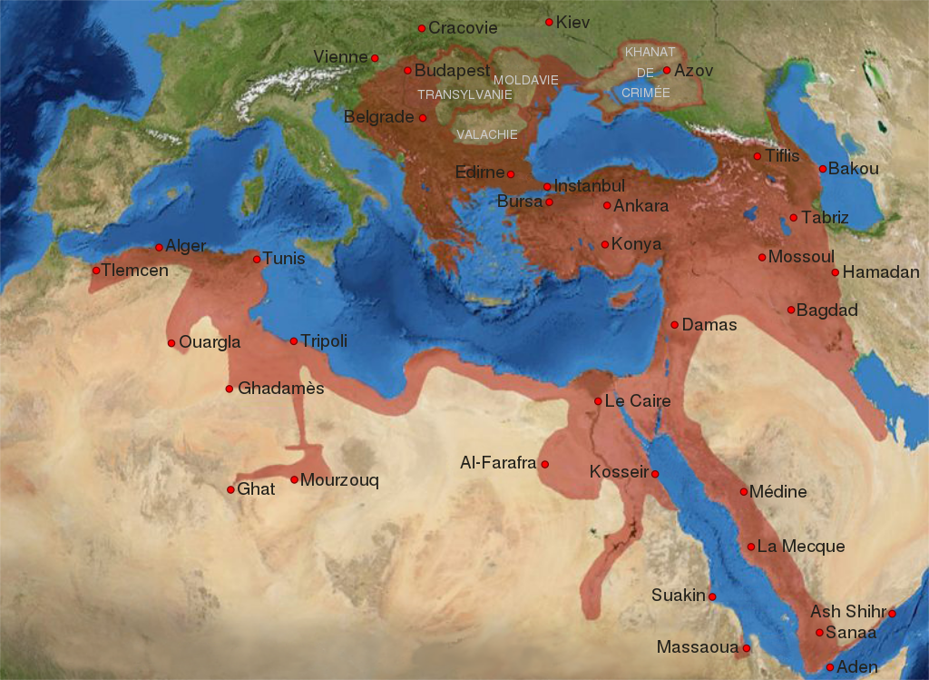
English: Map of the Ottoman Empire at its greatest extent, at the end of the 16th century (1600). Deutsch: Karte des Osmanischen Reiches in seiner größten Ausdehnung am Ende des 16. Jahrhunderts (ca. 1600) rectified 2013 since H.-E. Stier (dir.): « Westermann Grosser Atlas zur Weltgeschichte », 1985, ISBN 3-14-100919-8, pp. 96, 97, 103, 112. Français : Carte de l'Empire Ottoman à son apogée, vers la fin du XVIe siècle (1600). |
| Date | |
| Source | Ottoman Empire 16-17th century.jpg de lynxxx |
| Author | Original work : lynxxx, SVG : Flappiefh |
| Other versions |
|


|
This SVG file contains embedded text that can be translated into your language, using any capable SVG editor, text editor or the SVG Translate tool. For more information see: About translating SVG files. |
This W3C-unspecified vector image was created with Inkscape .
Licensing[edit]
| This work has been released into the public domain by its author, lynxxx at German Wikipedia. This applies worldwide. In some countries this may not be legally possible; if so: lynxxx grants anyone the right to use this work for any purpose, without any conditions, unless such conditions are required by law. |
File history
Click on a date/time to view the file as it appeared at that time.
| Date/Time | Thumbnail | Dimensions | User | Comment | |
|---|---|---|---|---|---|
| current | 17:32, 7 November 2021 | | 800 × 585 (978 KB) | باسم (talk | contribs) | File uploaded using svgtranslate tool (https://svgtranslate.toolforge.org/). Added translation for ar. |
| 19:51, 8 June 2013 |  | 800 × 585 (945 KB) | Bourrichon (talk | contribs) | correction petite coquille Transylvanie | |
| 17:33, 8 June 2013 |  | 800 × 585 (945 KB) | Flappiefh (talk | contribs) | User created page with UploadWizard |
You cannot overwrite this file.
File usage on Commons
The following 2 pages use this file:
File usage on other wikis
The following other wikis use this file:
- Usage on ar.wikipedia.org
- Usage on arz.wikipedia.org
- Usage on de.wikipedia.org
- Usage on fr.wikipedia.org
- Histoire du bassin méditerranéen
- Empire colonial
- Grand Siège de Malte
- Grèce ottomane
- Turquie
- Armée ottomane
- Wikipédia:Atelier graphique/Cartes/Archives/Demandes mises en sommeil/Asie
- Wikipédia:Atelier graphique/Cartes/Archives/juin 2013
- Campagnes militaires de Soliman le Magnifique
- Discussion:Prise de Fès (1554)
- Usage on fr.wiktionary.org
- Usage on hu.wikipedia.org
- Usage on it.wikipedia.org
- Usage on mg.wikipedia.org