File:Sunni-Shi'a map.png
Jump to navigation
Jump to search

Size of this preview: 800 × 388 pixels. Other resolutions: 320 × 155 pixels | 640 × 310 pixels | 1,246 × 604 pixels.
Original file (1,246 × 604 pixels, file size: 30 KB, MIME type: image/png)
Captions
Captions
Add a one-line explanation of what this file represents
Summary[edit]
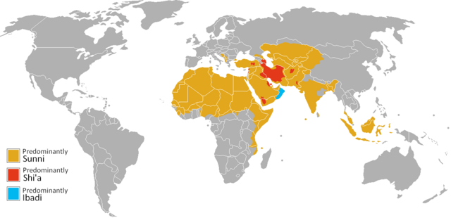
| Description | Map of predominantly Sunni or Shi'a regions in the world |
| Date | |
| Source | Own work |
| Author | DinajGao |
Licensing[edit]
| I, the copyright holder of this work, release this work into the public domain. This applies worldwide. In some countries this may not be legally possible; if so: I grant anyone the right to use this work for any purpose, without any conditions, unless such conditions are required by law. |
File history
Click on a date/time to view the file as it appeared at that time.
| Date/Time | Thumbnail | Dimensions | User | Comment | |
|---|---|---|---|---|---|
| current | 17:11, 30 April 2024 | | 1,246 × 604 (30 KB) | Iktsokh (talk | contribs) | Clearing the map |
| 18:25, 18 February 2018 |  | 1,246 × 604 (44 KB) | Artoxx (talk | contribs) | South Sudan | |
| 13:55, 6 February 2010 |  | 1,246 × 604 (52 KB) | DinajGao (talk | contribs) | fixes | |
| 12:24, 1 February 2010 |  | 1,246 × 604 (48 KB) | DinajGao (talk | contribs) | {{Information |Description=Map of predominantly Sunni or Shi'a regions in the world |Source={{own}} |Date=2010-02-01 |Author= DinajGao |Permission= |other_versions= }} Category:Maps of the world Category:Religion maps |
You cannot overwrite this file.
File usage on Commons
There are no pages that use this file.
File usage on other wikis
The following other wikis use this file:
- Usage on ba.wikipedia.org
- Usage on be.wikipedia.org
- Usage on de.wikipedia.org