File:Административна карта на Македонија, почеток на ХХ век.pdf
Jump to navigation
Jump to search
Size of this JPG preview of this PDF file: 765 × 599 pixels. Other resolutions: 307 × 240 pixels | 613 × 480 pixels | 981 × 768 pixels | 1,260 × 987 pixels.
Original file (1,260 × 987 pixels, file size: 8.85 MB, MIME type: application/pdf)
Captions
Captions
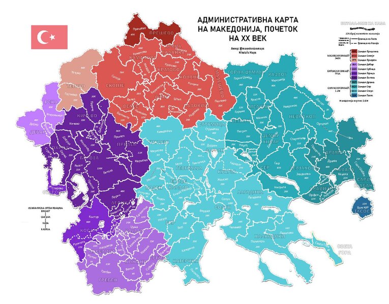
Administrative division of Macedonia under Ottoman rule, beginning of XX century
Summary[edit]
| Description |
English: The division is based on the official Ottoman administration document. Colors are representing the vilayets and sanjaks and with lines I further divide kazas and nahiyas. It is shown their name and the number of people living inside every nahiya, sanjak, vilayet and generally in the whole region of Macedonia.
Македонски: Поделбата е основана врз официјален османлиски документ. Со бои ги означив вилаетите и санџаците, додека пак со линии се означени казите и нахиите. Исто така ги прикажав и имињата на сите единици и бројот на жители во нахиите, санџаците, вилаетите, како и на целиот регион. |
| Date | |
| Source | Own work |
| Author | Nikola0505 |
Licensing[edit]
I, the copyright holder of this work, hereby publish it under the following license:
| This file is made available under the Creative Commons CC0 1.0 Universal Public Domain Dedication. | |
| The person who associated a work with this deed has dedicated the work to the public domain by waiving all of their rights to the work worldwide under copyright law, including all related and neighboring rights, to the extent allowed by law. You can copy, modify, distribute and perform the work, even for commercial purposes, all without asking permission.
|
File history
Click on a date/time to view the file as it appeared at that time.
| Date/Time | Thumbnail | Dimensions | User | Comment | |
|---|---|---|---|---|---|
| current | 15:12, 5 December 2023 |  | 1,260 × 987 (8.85 MB) | MacedonianMaps (talk | contribs) | Uploaded own work with UploadWizard |
You cannot overwrite this file.
File usage on Commons
There are no pages that use this file.