File:Зона возможных рисков.jpg
From Wikimedia Commons, the free media repository
Jump to navigation
Jump to search
Зона_возможных_рисков.jpg (580 × 329 pixels, file size: 138 KB, MIME type: image/jpeg)
File information
Structured data
Captions
Captions
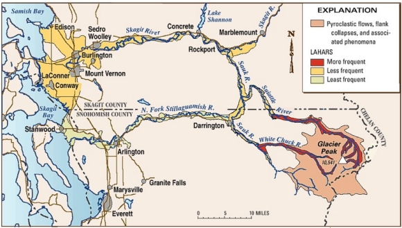
Areas at risk from lahars, lava domes, pyroclastic flows, and associated phenomena from Glacier Peak. Map modified from R.B. Waitt and others, U.S. Geological Survey.
Summary[edit]
| DescriptionЗона возможных рисков.jpg |
English: Areas at risk from lahars, lava domes, pyroclastic flows, and associated phenomena from Glacier Peak. Map modified from R.B. Waitt and others, U.S. Geological Survey Русский: Зона возможных рисков, составленная USGS. |
| Date |
1990s date QS:P,+1990-00-00T00:00:00Z/8 |
| Source | http://pubs.usgs.gov/fs/2000/fs058-00/ |
| Author | USGS |
Licensing[edit]
| Public domainPublic domainfalsefalse |
Это изображение находится в общественном достоянии, так как содержит материалы, которые первоначально получены от Геологической службы США (USGS) — агентства Министерства внутренних дел США. Дополнительную информацию см. «Официальная политика авторского права USGS» (англ.).
Bahasa Indonesia ∙ català ∙ čeština ∙ Deutsch ∙ eesti ∙ English ∙ español ∙ français ∙ galego ∙ italiano ∙ Nederlands ∙ português ∙ polski ∙ sicilianu ∙ suomi ∙ Tiếng Việt ∙ Türkçe ∙ български ∙ македонски ∙ русский ∙ മലയാളം ∙ 한국어 ∙ 日本語 ∙ 中文 ∙ 中文(简体) ∙ 中文(繁體) ∙ العربية ∙ فارسی ∙ +/− |
File history
Click on a date/time to view the file as it appeared at that time.
| Date/Time | Thumbnail | Dimensions | User | Comment | |
|---|---|---|---|---|---|
| current | 13:10, 2 May 2013 |  | 580 × 329 (138 KB) | Bortorix (talk | contribs) | User created page with UploadWizard |
You cannot overwrite this file.
File usage on Commons
There are no pages that use this file.
File usage on other wikis
The following other wikis use this file:
- Usage on ru.wikipedia.org

