File:1737 Homann Heirs Map of New England, Georgia and Carolina, and Virginia and Maryland - Geographicus - DominiaAnglorum-hmhr-1737.jpg
From Wikimedia Commons, the free media repository
Jump to navigation
Jump to search

Size of this preview: 669 × 600 pixels. Other resolutions: 268 × 240 pixels | 536 × 480 pixels | 857 × 768 pixels | 1,143 × 1,024 pixels | 2,285 × 2,048 pixels | 5,000 × 4,481 pixels.
Original file (5,000 × 4,481 pixels, file size: 6.49 MB, MIME type: image/jpeg)
File information
Structured data
Captions
Captions
Add a one-line explanation of what this file represents
| Johann Homann: Dominia Anglorum in America Septentrionali. Specialibus Mappis Londini Primum a Mollio Edita, Nunc Recusa ab Homannianis Hered.
( |
||||||||||||||||||||||||
|---|---|---|---|---|---|---|---|---|---|---|---|---|---|---|---|---|---|---|---|---|---|---|---|---|
| Artist |
artist QS:P170,Q62706 |
|||||||||||||||||||||||
| Title |
Dominia Anglorum in America Septentrionali. Specialibus Mappis Londini Primum a Mollio Edita, Nunc Recusa ab Homannianis Hered. |
|||||||||||||||||||||||
| Description |
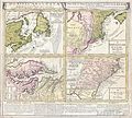
English: A spectacular example of the Homan Heirs 1737 map of the British Territories in North America. Divided into four separate maps derived from the work of Herman Moll. Covers much of the eastern coast of North America including Nova Scotia & Newfoundland, New England (New York, New Jersey, Massachusetts, Pennsylvania, etc..), Virginia & Maryland, and Carolina ( now North Carolina, South Carolina, Georgia) and northern Florida. The upper left quadrant features a map of the Maritime Provinces of Newfoundland and Nova Scotia. Offers wonderful detail both inland and offshore, with special attention to the shoals. Upper right hand quadrant features much of New England, New York and parts of Pennsylvania and New Jersey. The Jerseys are shown spit into eastern and western provinces according to their original charters. New York extends northward past Lake Champlain, which is itself set significantly south and west of its actual location. Notes Albany. Lower left quadrant features a map of those parts of Virginia and Maryland adjoining the Chesapeake Bay. Lower right quadrant features much of what is today North Carolina, South Carolina, Georgia, Alabama and Northern Florida. Notes land dispute with the Spanish territories with regard to the rights to Northern Florida, referencing various charters to the Carolinas. Predates Georgia. Excellent detail both inland and along the coast. Bounded on the western end by the Appalachian Mountains. Below the map is a large text area with notations on the land and peoples depicted, including a special commentary dedicated to the Iroquois Nation. |
|||||||||||||||||||||||
| Date |
circa 1737 date QS:P571,+1737-00-00T00:00:00Z/9,P1480,Q5727902 (undated) |
|||||||||||||||||||||||
| Dimensions |
height: 19.5 in (49.5 cm); width: 21.5 in (54.6 cm) dimensions QS:P2048,19.5U218593 dimensions QS:P2049,21.5U218593 |
|||||||||||||||||||||||
| Accession number |
Geographicus link: DominiaAnglorum-hmhr-1737 |
|||||||||||||||||||||||
| Source/Photographer |
|
|||||||||||||||||||||||
| Permission (Reusing this file) |
|
|||||||||||||||||||||||
File history
Click on a date/time to view the file as it appeared at that time.
| Date/Time | Thumbnail | Dimensions | User | Comment | |
|---|---|---|---|---|---|
| current | 16:41, 16 March 2011 |  | 5,000 × 4,481 (6.49 MB) | BotMultichill (talk | contribs) | {{subst:User:Multichill/Geographicus |link=http://www.geographicus.com/P/AntiqueMap/DominiaAnglorum-hmhr-1737 |product_name=1737 Homann Heirs Map of New England, Georgia and Carolina, and Virginia and Maryland |map_title=Dominia Anglorum in America Septen |
You cannot overwrite this file.
File usage on Commons
The following page uses this file:
