File:1827 Finley Map of Mexico, Upper California and Texas - Geographicus - Mexico-finely-1827.jpg
Jump to navigation
Jump to search
Size of this preview: 800 × 582 pixels. Other resolutions: 320 × 233 pixels | 640 × 466 pixels | 1,024 × 745 pixels | 1,280 × 932 pixels | 2,560 × 1,864 pixels | 3,000 × 2,184 pixels.
Original file (3,000 × 2,184 pixels, file size: 1.7 MB, MIME type: image/jpeg)
Captions
Captions
Add a one-line explanation of what this file represents
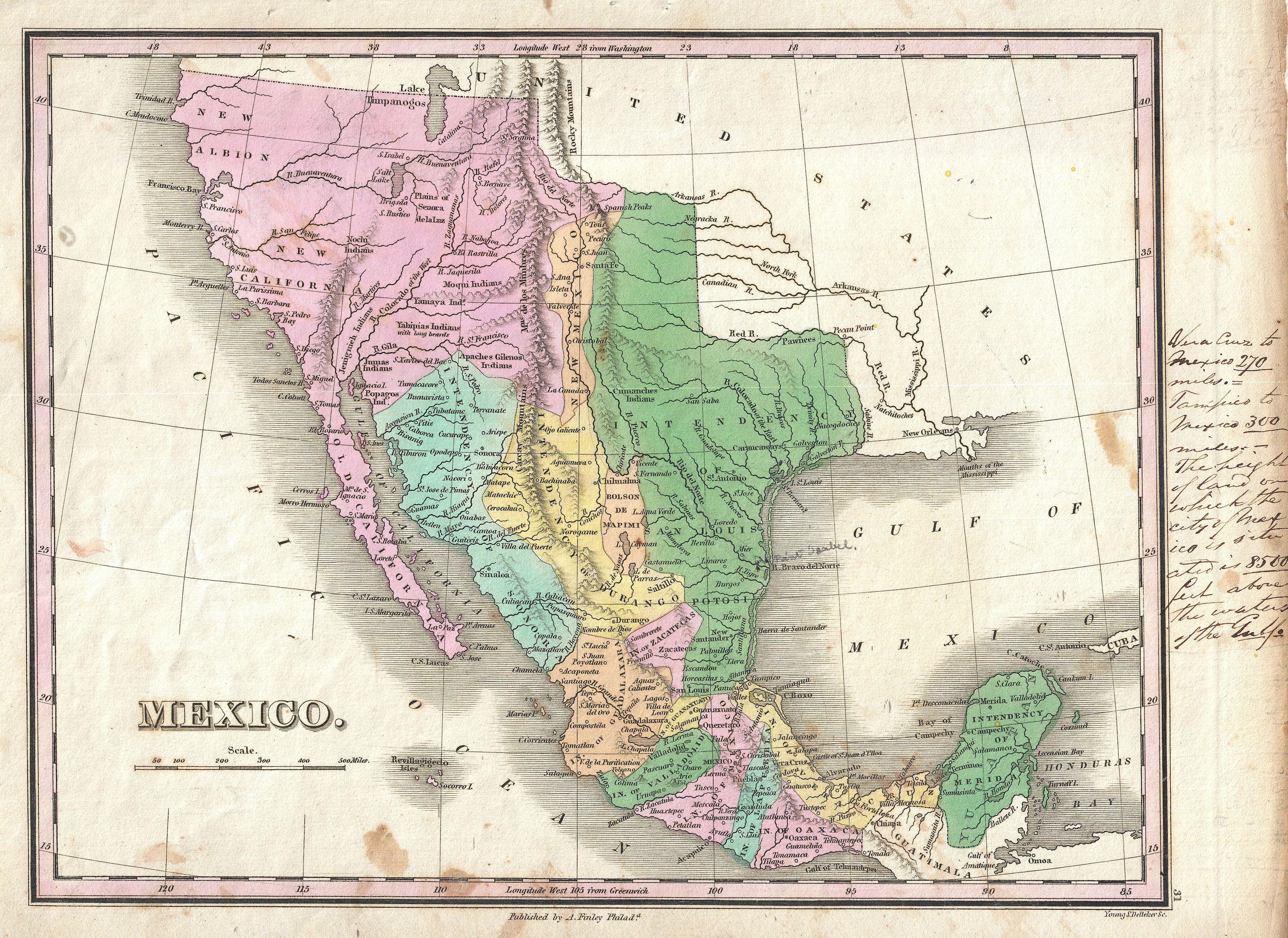
| Anthony Finley: Mexico.
( |
||||||||||||||
|---|---|---|---|---|---|---|---|---|---|---|---|---|---|---|
| Artist |
|
|||||||||||||
| Title |
Mexico. |
|||||||||||||
| Description |
English: A scarce and important 1827 map of Mexico by Anthony Finley. Covers from upper California and New Albion south to Guatemala, including the modern day regions of California, New Mexico, Arizona, Colorado, Utah, Nevada, Texas and Mexico. Offers an interesting pre-Republic mapping of Texas folded into the Intendency of San Louis Potosi. Here New Mexico, previously a vast territory, is limited to a narrow sliver of land attached to the upper Rio Norte or Rio Grande. Further west this map really gets interesting with the explorations of Escalante and Humboldt very much in evidence. Finley curiously charts two lakes in the Great Basin, one labeled Timpanagos and another smaller lake further south labeled Salt Lake. The Great Salt Lake is said to have first been seen by Europeans in 1824, only a few years before this map was published, so it is unlikely that Finley drew from this exploration. Instead, Finely is following Escalante's discoveries as recorded on the Miera map. The Escalante expedition actually visited Utah Lake (Timpanagos), but only heard about the Great Salt Lake from local native American Ute tribe. Miera, Escalante's cartographer, thus mapped Timpanagos as much larger than the unseen Great Salt Lake. Finley also maps the Buenaventura River running from the Rocky Mountains westward through Salt Lake and westward to San Francisco Bay. The Buenaventura is the last incarnation of the apocryphal River of the West, a long sought after speculative alternative to the Northwest Passage. The mapping of Buenaventura here again references legitimate discoveries by Escalante of the White River and the Sevier River. In this case, both are mistakenly associated with the River of the West and given an erroneous outlet into San Francisco Bay. In addition to geographical notations, Finley also identifies a number of American Indian nations including the Moqui, Apache, Juma, Nochi, Poagos and Yahipias (with long beards). Engraved by Young and Delleker for the 1827 edition of Anthony Finley's General Atlas . |
|||||||||||||
| Date | 1827 (undated) | |||||||||||||
| Dimensions | height: 9 in (22.8 cm); width: 11.5 in (29.2 cm) | |||||||||||||
| Accession number |
Geographicus link: Mexico-finely-1827 |
|||||||||||||
| Source/Photographer |
Finley, Anthony, A New General Altas, Comprising a Complete Set of Maps, representing the Grand Divisions of the Globe, Together with the several Empires, Kingdoms and States in the World; Compiled from the Best Authorities, and corrected by the Most Recent Discoveries, Philadelphia, 1827.
|
|||||||||||||
| Permission (Reusing this file) |
|
|||||||||||||
File history
Click on a date/time to view the file as it appeared at that time.
| Date/Time | Thumbnail | Dimensions | User | Comment | |
|---|---|---|---|---|---|
| current | 08:31, 23 March 2011 | | 3,000 × 2,184 (1.7 MB) | BotMultichillT (talk | contribs) | {{subst:User:Multichill/Geographicus |link=http://www.geographicus.com/P/AntiqueMap/Mexico-finely-1827 |product_name=1827 Finley Map of Mexico, Upper California and Texas |map_title=Mexico. |description=A scarce and important 1827 map of Mexico by Anthony |
You cannot overwrite this file.
File usage on Commons
The following page uses this file:
File usage on other wikis
The following other wikis use this file:
- Usage on es.wikipedia.org