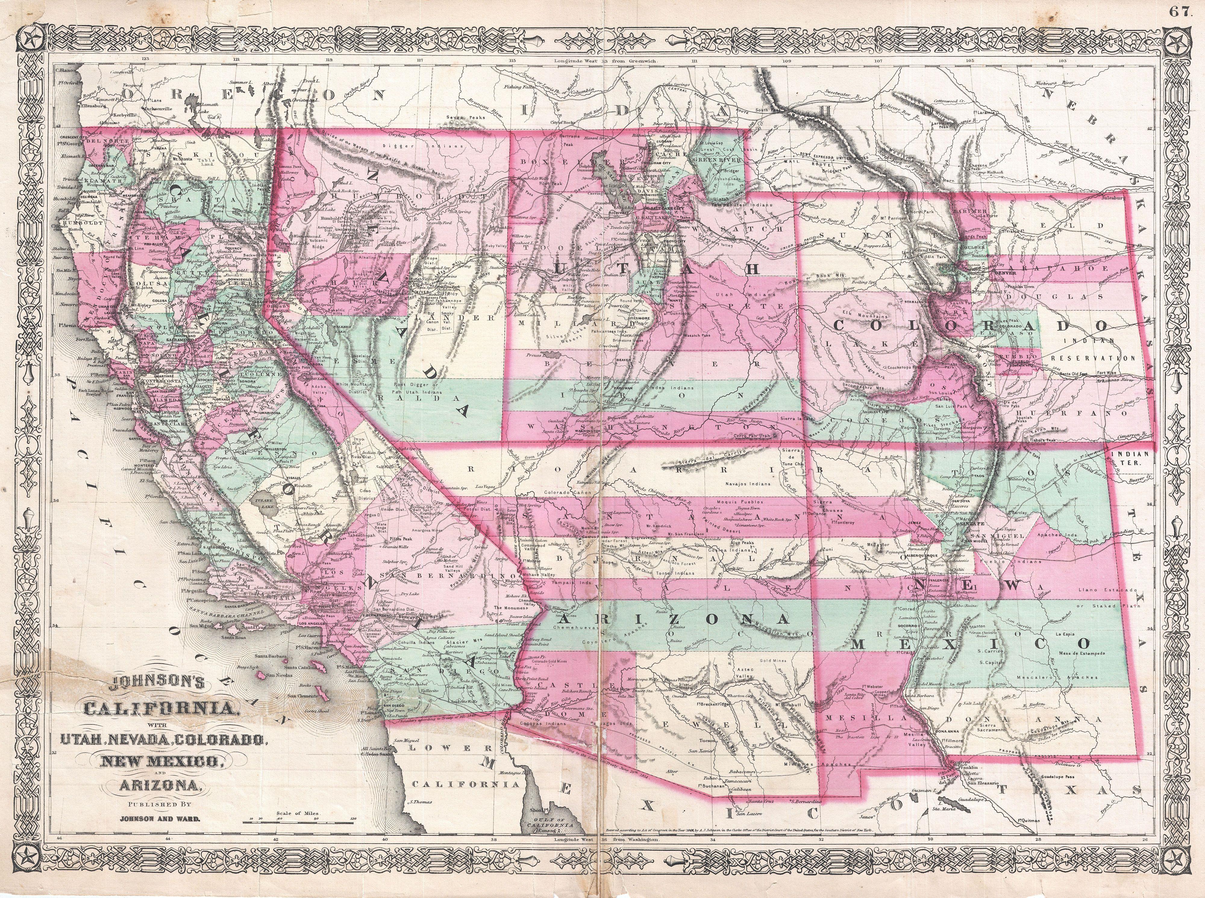
File:1864 Johnson Map of California, Nevada, Utah, Arizona, New Mexico and Colorado - Geographicus - Southwest2-johnson-1864.jpg
Original file (4,000 × 2,981 pixels, file size: 3.46 MB, MIME type: image/jpeg)
Captions
Captions
Summary
[edit]
| Alvin Jewett Johnson: Johnson's California, with Territories of Utah, Nevada, Colorado, New Mexico and Arizona.
( |
|||||||||||||||||||||||
|---|---|---|---|---|---|---|---|---|---|---|---|---|---|---|---|---|---|---|---|---|---|---|---|
| Artist |
|
||||||||||||||||||||||
| Title |
Johnson's California, with Territories of Utah, Nevada, Colorado, New Mexico and Arizona. |
||||||||||||||||||||||
| Description |
English: This is Johnson and Ward’s 1864 map of the American southwest. Depicts the state of California and the territories of Nevada, Utah, Colorado, Arizona and New Mexico. Offers superb detail noting mining districts, emigrant trails, the Santa Fe Trail, the Pony Express Route and several proposed railroads as well as American Indian tribes, geological features, and local political divisions. Features the fretwork border common to Johnson’s atlas work from 1864 to 1869. This important map went through several different states during its publication period from 1860 to 1870. This critical period in westward expansion saw incredible development and change throughout the region. Collecting the various states of this map has become something of a sub-genre for southwestern map aficionados. Johnson updated the plates for this map annually and sometimes even issued multiple variants the course of a single year. This, the 1864 Johnson and Ward version represents a complete re-engraving of the 1862-1863 map. Johnson added considerable detail in the mountainous regions of California, Nevada and Colorado. Arizona and New Mexico appear as independent territories but adhere to the old “New Mexico” county structure. The southern boundary of Nevada with Arizona is set at 37 degrees of Latitude such that Las Vegas, which is noted, rests firmly within Arizona. The Utah-Nevada Border is set at 115 degrees of Longitude, roughly one degree further west than it is today. Steel plate engraving prepared by A. J. Johnson for publication as plate no. 67 in the 1864 edition of his New Illustrated Atlas… This is the last edition of the Johnson’s Atlas to bear the Johnson and Ward imprint. |
||||||||||||||||||||||
| Date | 1864 (dated) | ||||||||||||||||||||||
| Dimensions | height: 17.2 in (43.8 cm); width: 23.7 in (60.3 cm) | ||||||||||||||||||||||
| Accession number |
Geographicus link: Southwest2-johnson-1864 |
||||||||||||||||||||||
| Source/Photographer |
Johnson's New Illustrated Family Atlas, 1864 Johnson & Ward Edition.
|
||||||||||||||||||||||
| Permission (Reusing this file) |
|
||||||||||||||||||||||
Licensing
[edit]
|
The author died in 1884, so this work is in the public domain in its country of origin and other countries and areas where the copyright term is the author's life plus 100 years or fewer. This work is in the public domain in the United States because it was published (or registered with the U.S. Copyright Office) before January 1, 1929. | |
| This file has been identified as being free of known restrictions under copyright law, including all related and neighboring rights. | |
File history
Click on a date/time to view the file as it appeared at that time.
| Date/Time | Thumbnail | Dimensions | User | Comment | |
|---|---|---|---|---|---|
| current | 19:51, 12 April 2024 | | 4,000 × 2,981 (3.46 MB) | SDudley (talk | contribs) | Reverted to version as of 09:11, 18 March 2011 (UTC) i got it wrong; different map |
| 19:43, 12 April 2024 |  | 14,813 × 10,240 (22.86 MB) | SDudley (talk | contribs) | larger resolution from different source | |
| 09:11, 18 March 2011 |  | 4,000 × 2,981 (3.46 MB) | BotMultichill (talk | contribs) | {{subst:User:Multichill/Geographicus |link=http://www.geographicus.com/P/AntiqueMap/Southwest2-johnson-1864 |product_name=1864 Johnson Map of California, Nevada, Utah, Arizona, New Mexico and Colorado |map_title=Johnson's California, with Territories of U |
You cannot overwrite this file.
File usage on Commons
The following page uses this file:
File usage on other wikis
The following other wikis use this file:
- Usage on nl.wikipedia.org