File:1867 Mitchell Map of Baltimore, Maryland - Geographicus - Baltimore-mitchell-1867.jpg
Jump to navigation
Jump to search

Size of this preview: 708 × 600 pixels. Other resolutions: 283 × 240 pixels | 567 × 480 pixels | 906 × 768 pixels | 1,208 × 1,024 pixels | 2,417 × 2,048 pixels | 3,500 × 2,966 pixels.
Original file (3,500 × 2,966 pixels, file size: 3.41 MB, MIME type: image/jpeg)
Captions
Captions
Add a one-line explanation of what this file represents
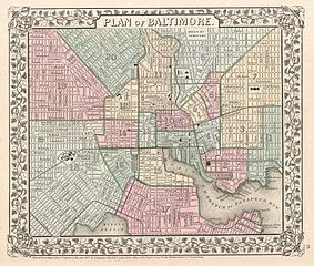
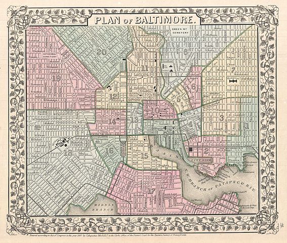
| Samuel Augustus Mitchell: Plan of Baltimore.
( |
||||||||||||||||||||
|---|---|---|---|---|---|---|---|---|---|---|---|---|---|---|---|---|---|---|---|---|
| Artist |
|
|||||||||||||||||||
| Title |
Plan of Baltimore. |
|||||||||||||||||||
| Description |
English: A beautiful example of S. A. Mitchell Jr.’s 1867 map of Baltimore, Maryland. Covers Baltimore from the Northwest Brach of the Patapsco River and Locust Point northwards as far as Green Mountain Cemetary and Oliver Street. Hand colored in pink, green, yellow and blue pastels to identify city wards. In general this map offers extraordinary detail at level of individual streets and buildings. Identifies the city Hospital, Railroad Depot, Mt. Clare Station, St. Mary's College, and the City Jail, among many other sites. Surrounded by the attractive vine motif border common to Mitchell atlases between 1866 and 1880. One of the more attractive atlas maps of Baltimore to appear in the latter half of the 19th century. Prepared by S. A. Mitchell Jr. for inclusion as plate no. 28 in the 1867 issue of Mitchell’s New General Atlas . Dated and copyrighted, “Entered according to Act of Congress in the Year 1867 by S. Augustus Mitchell Jr. in the Clerks Office of the District Court for the Eastern District of Pennsylvania. |
|||||||||||||||||||
| Date | 1867 (dated) | |||||||||||||||||||
| Dimensions | height: 10 in (25.4 cm); width: 11.5 in (29.2 cm) | |||||||||||||||||||
| Accession number |
Geographicus link: Baltimore-mitchell-1867 |
|||||||||||||||||||
| Source/Photographer |
Mitchell Jr., S. A.,Mitchell's new general atlas, containing maps of the various countries of the World, plans of cities, etc., 1867 edition.
|
|||||||||||||||||||
| Permission (Reusing this file) |
|
|||||||||||||||||||
File history
Click on a date/time to view the file as it appeared at that time.
| Date/Time | Thumbnail | Dimensions | User | Comment | |
|---|---|---|---|---|---|
| current | 22:28, 24 March 2011 | | 3,500 × 2,966 (3.41 MB) | BotMultichillT (talk | contribs) | {{subst:User:Multichill/Geographicus |link=http://www.geographicus.com/P/AntiqueMap/Baltimore-mitchell-1867 |product_name=1867 Mitchell Map of Baltimore, Maryland |map_title=Plan of Baltimore. |description=A beautiful example of S. A. Mitchell Jr.’s 186 |
You cannot overwrite this file.
File usage on Commons
The following page uses this file:
File usage on other wikis
The following other wikis use this file:
- Usage on en.wikipedia.org
- Usage on www.wikidata.org