File:1897-topo-map-morro-bay-4841-2041x2660 (5544645420).jpg

Original file (2,041 × 2,660 pixels, file size: 5.75 MB, MIME type: image/jpeg)
Captions
Captions
Summary[edit]
.jpg&action=edit§ion=1)
| Description |
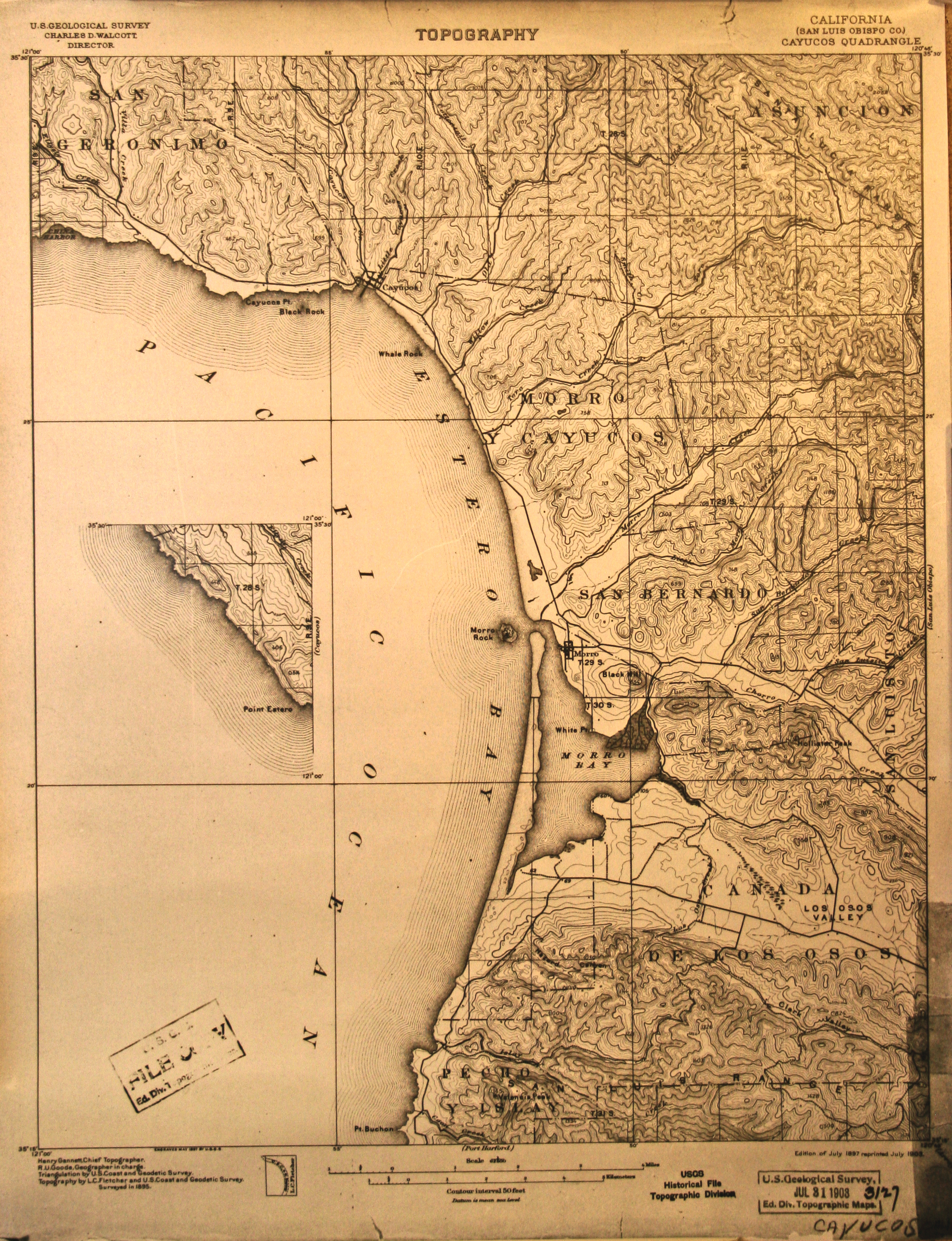
Topo Map. TOPOGRAPHY. California (San Luis Obisps Co.) Cayucos Quadrangle, including Morro Bay, Los Osos, Cayucos, Pecho Y Islay, Cañada de Los Osos, Los Osos Valley, Montaña de Oro, San Luisito, San Bernardo, Morro, Cayucos, Cayucos Pt., San Geronimo, Estero Bay, Point Estero, Morro Rock. Edition of July 1897 Topo Map Printed July 1908 from U. S. Geological Survey, Jul 31, 1908, 3127, Ed. Div. Topographic Maps, Henry Gannett, Chief Topographer, R. U. Goode, Geographer in charge. Triangulation by U. S. Coast and Geodetic Survey. Topography by L. C. Fietcher and U. S. Coast and Geodetic Survey. Surveyed in 1895. 2041x2660. Photographed by Mike Baird form a copy owned by Freeman Hall. Published at <a href="http://morro-bay.com/photos-maps/topo-1897/1897-topo-map-morro-bay-4841-2041x2660.jpg" rel="nofollow">morro-bay.com/photos-maps/topo-1897/1897-topo-map-morro-b...</a> See <a href="http://imgzoom.cdlib.org/Fullscreen.ics?ark=ark:/13030/hb638nb737/z1&&brand=calisphere" rel="nofollow">imgzoom.cdlib.org/Fullscreen.ics?ark=ark:/13030/hb638nb73...</a> from <a href="http://content.cdlib.org/ark:/13030/hb638nb737/" rel="nofollow">content.cdlib.org/ark:/13030/hb638nb737/</a> for an old 1874 topo map of the entire San Luis Obispo County, Courtesy of Dept of Special Collections/UCLA Library, A1713 Charles E. Young Research Library, 405 Hilgard Ave, Box 951575, Los Angeles, CA 90095-1575; <a href="http://www.library.ucla.edu/libraries/special/scweb/" rel="nofollow">www.library.ucla.edu/libraries/special/scweb/</a> <a href="http://content.cdlib.org/ark:/13030/hb638nb737/?brand=calisphere" rel="nofollow">content.cdlib.org/ark:/13030/hb638nb737/?brand=calisphere</a> brought to our attention by Flickr user Charlie <a href="https://www.flickr.com/photos/34844941@N03/">www.flickr.com/photos/34844941@N03/</a> |
| Date | |
| Source | 1897-topo-map-morro-bay-4841-2041x2660 |
| Author | Mike Baird from Morro Bay, USA |
Licensing[edit]
.jpg&action=edit§ion=2)
- You are free:
- to share – to copy, distribute and transmit the work
- to remix – to adapt the work
- Under the following conditions:
- attribution – You must give appropriate credit, provide a link to the license, and indicate if changes were made. You may do so in any reasonable manner, but not in any way that suggests the licensor endorses you or your use.
| This image was originally posted to Flickr by mikebaird at https://flickr.com/photos/72825507@N00/5544645420. It was reviewed on 13 October 2020 by FlickreviewR 2 and was confirmed to be licensed under the terms of the cc-by-2.0. |
File history
Click on a date/time to view the file as it appeared at that time.
| Date/Time | Thumbnail | Dimensions | User | Comment | |
|---|---|---|---|---|---|
| current | 00:43, 13 October 2020 | | 2,041 × 2,660 (5.75 MB) | Geo Swan (talk | contribs) | Transferred from Flickr via #flickr2commons |
You cannot overwrite this file.
File usage on Commons
There are no pages that use this file.
.jpg&oldid=746343441)