File:1918 Flu pandemic-en.svg
Jump to navigation
Jump to search

Size of this PNG preview of this SVG file: 560 × 375 pixels. Other resolutions: 320 × 214 pixels | 640 × 429 pixels | 1,024 × 686 pixels | 1,280 × 857 pixels | 2,560 × 1,714 pixels.
Original file (SVG file, nominally 560 × 375 pixels, file size: 224 KB)
Captions
Captions
Add a one-line explanation of what this file represents
Summary[edit]
| Description |
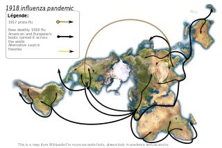
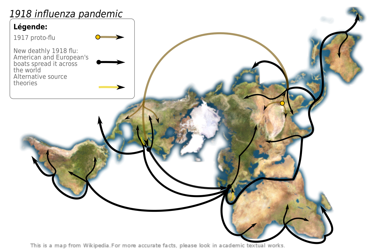
Map showing the 1918 Flu pandemic. Made according to Institut pasteur's data, graphism made by myself. Sources:
Pr. Hannoun being one of the world leading experts of the 1918 influenza, and the Institut Pasteur leading expert. In his paper, he support the Chinese origin, but also notice other theories.
|
||
| Date | (UTC) | ||
| Source | |||
| Author |
|
||
| SVG development |
|
Licensing[edit]
This file is licensed under the Creative Commons Attribution-Share Alike 3.0 Unported license.
- You are free:
- to share – to copy, distribute and transmit the work
- to remix – to adapt the work
- Under the following conditions:
- attribution – You must give appropriate credit, provide a link to the license, and indicate if changes were made. You may do so in any reasonable manner, but not in any way that suggests the licensor endorses you or your use.
- share alike – If you remix, transform, or build upon the material, you must distribute your contributions under the same or compatible license as the original.
Original upload log[edit]
This image is a derivative work of the following images:
- Image:Dymaxion_map_unfolded-no-ocean.png licensed with PD-self
- 2005-08-28T12:36:31Z Rhythm 638x365 (137983 Bytes) this image may be subsitude by this other bigger one [[Image:Dymaxion continents.jpg|thumb]] ==Description== This is an unfolded [[dymaxion map]], unfolded to show the land-masses of the world as nearly continuous. This is a
Uploaded with derivativeFX
File history
Click on a date/time to view the file as it appeared at that time.
| Date/Time | Thumbnail | Dimensions | User | Comment | |
|---|---|---|---|---|---|
| current | 14:15, 1 May 2009 | | 560 × 375 (224 KB) | Yug (talk | contribs) | improvement : legend, colors, crop. |
| 01:00, 26 July 2008 |  | 638 × 365 (257 KB) | Yug (talk | contribs) | image size restored | |
| 00:56, 26 July 2008 |  | 638 × 365 (255 KB) | Yug (talk | contribs) | fix arrow bugs... putain j'en chie ! | |
| 00:42, 26 July 2008 |  | 638 × 365 (221 KB) | Yug (talk | contribs) | try again after sudo apt-get install python-lxml | |
| 00:34, 26 July 2008 |  | 638 × 365 (40 KB) | Yug (talk | contribs) | Try to avoid the embeded image bug | |
| 00:30, 26 July 2008 |  | 638 × 365 (40 KB) | Yug (talk | contribs) | {{Information |Description=Map showing the 1918 Flu pandemic. Data from personal research (source : Intitut pasteur), graphism made by myself. ;Derivate from Image:Dymaxion_map_unfolded-no-ocean.png This image may be substituted by this other bigger |
You cannot overwrite this file.
File usage on Commons
The following 2 pages use this file:
File usage on other wikis
The following other wikis use this file:
- Usage on en.wikipedia.org
- Usage on en.wikiquote.org
- Usage on hu.wikipedia.org
- Usage on is.wikipedia.org
- Usage on ln.wikipedia.org
- Usage on mk.wikipedia.org