File:2012 Assam Violence map.svg
Jump to navigation
Jump to search

Size of this PNG preview of this SVG file: 419 × 565 pixels. Other resolutions: 178 × 240 pixels | 356 × 480 pixels | 569 × 768 pixels | 759 × 1,024 pixels | 1,519 × 2,048 pixels.
Original file (SVG file, nominally 419 × 565 pixels, file size: 317 KB)
Captions
Captions
Add a one-line explanation of what this file represents
Summary[edit]
| Description |
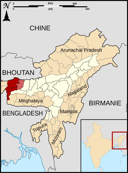
English: Map showing districts of Kokrajhar (top left,coloured red), Dhubri (bottom left,coloured red) and Chirang_district (formed out of parts of Bongaigaon_district (top right, coloured pink) affected by 2012 Assam violence |
| Date | |
| Source | Derived from India Assam locator map.svg by User:Sardon |
| Author | User:Evano1van |
Licensing[edit]
This file is licensed under the Creative Commons Attribution-Share Alike 3.0 Unported license.
- You are free:
- to share – to copy, distribute and transmit the work
- to remix – to adapt the work
- Under the following conditions:
- attribution – You must give appropriate credit, provide a link to the license, and indicate if changes were made. You may do so in any reasonable manner, but not in any way that suggests the licensor endorses you or your use.
- share alike – If you remix, transform, or build upon the material, you must distribute your contributions under the same or compatible license as the original.
File history
Click on a date/time to view the file as it appeared at that time.
| Date/Time | Thumbnail | Dimensions | User | Comment | |
|---|---|---|---|---|---|
| current | 06:15, 15 March 2013 | | 419 × 565 (317 KB) | Evano1van (talk | contribs) | User created page with UploadWizard |
You cannot overwrite this file.
File usage on Commons
The following page uses this file:
File usage on other wikis
The following other wikis use this file:
- Usage on bn.wikipedia.org
- Usage on en.wikipedia.org
- Usage on fa.wikipedia.org
- Usage on fr.wikipedia.org