File:A421 developments.svg
Jump to navigation
Jump to search

Size of this PNG preview of this SVG file: 800 × 560 pixels. Other resolutions: 320 × 224 pixels | 640 × 448 pixels | 1,024 × 717 pixels | 1,280 × 896 pixels | 2,560 × 1,792 pixels | 913 × 639 pixels.
Original file (SVG file, nominally 913 × 639 pixels, file size: 8 KB)
Captions
Captions
Add a one-line explanation of what this file represents
Summary[edit]
| Description |
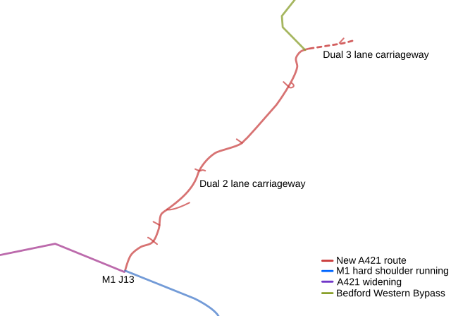
English: A map showing road developments taking place in the region of the A421 Bedford to Milton Keynes. |
| Date | |
| Source | Own work work over Open Street Map data |
| Author | EricITOworld |
Licensing[edit]
I, the copyright holder of this work, hereby publish it under the following licenses:
This file is licensed under the Creative Commons Attribution-Share Alike 3.0 Unported license.
- You are free:
- to share – to copy, distribute and transmit the work
- to remix – to adapt the work
- Under the following conditions:
- attribution – You must give appropriate credit, provide a link to the license, and indicate if changes were made. You may do so in any reasonable manner, but not in any way that suggests the licensor endorses you or your use.
- share alike – If you remix, transform, or build upon the material, you must distribute your contributions under the same or compatible license as the original.

|
Permission is granted to copy, distribute and/or modify this document under the terms of the GNU Free Documentation License, Version 1.2 or any later version published by the Free Software Foundation; with no Invariant Sections, no Front-Cover Texts, and no Back-Cover Texts. A copy of the license is included in the section entitled GNU Free Documentation License. |
You may select the license of your choice.
File history
Click on a date/time to view the file as it appeared at that time.
| Date/Time | Thumbnail | Dimensions | User | Comment | |
|---|---|---|---|---|---|
| current | 13:21, 30 June 2010 | | 913 × 639 (8 KB) | DieBuche (talk | contribs) | Try to fix SVG using scour |
| 14:06, 2 November 2009 |  | 913 × 639 (13 KB) | EricITOworld (talk | contribs) | Reverted to version as of 12:22, 27 October 2009 - as commons does not like updated version of different file type. | |
| 14:05, 2 November 2009 |  | 966 × 714 (283 KB) | EricITOworld (talk | contribs) | .png'd the file so will now thumbnail correctly. Is otherwise same as previous .svg images. | |
| 12:22, 27 October 2009 |  | 913 × 639 (13 KB) | EricITOworld (talk | contribs) | Another shot at having the background image show up. | |
| 12:21, 27 October 2009 |  | 913 × 639 (13 KB) | EricITOworld (talk | contribs) | edited the file name that the file points to for the background image. | |
| 12:19, 27 October 2009 |  | 913 × 639 (13 KB) | EricITOworld (talk | contribs) | {{Information |Description={{en|1=A map showing road developments taking place in the region of the A421 Bedford to Milton Keynes.}} |Source={{own}} work over Open Street Map data |Author=EricITOworld |Date=2009-10-27 |Permission= |o |
You cannot overwrite this file.
File usage on Commons
The following page uses this file:
File usage on other wikis
The following other wikis use this file:
- Usage on en.wikipedia.org