File:AI Mk.IV radar display E(MOS)1448.jpg
Original file (800 × 610 pixels, file size: 40 KB, MIME type: image/jpeg)
Captions
Captions
Summary[edit]
1448.jpg&action=edit§ion=1)
| Description |
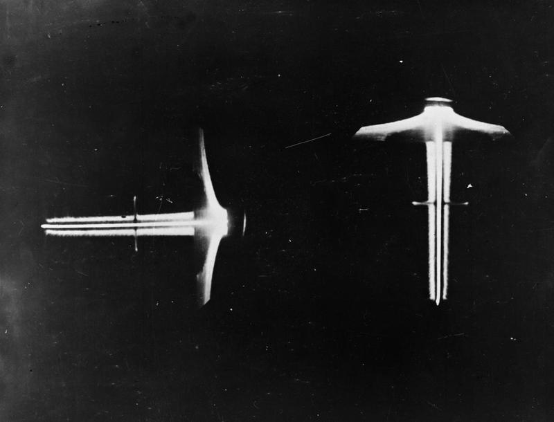
English: The AI Mk. IV radar used two CRTs (oscilloscopes) to display the vertical and horizontal situations. The altitude display on the left shows the vertical situation, while the azimuth display on the right shows the horizontal.
This display shows a single "blip" about half way along the lines, indicating a range of about 10,000 feet from the aircraft. The blip is roughly centred across the axis of the vertical display, suggesting the target is at roughly the same altitude as the fighter. The blip is not directly centred on the horizontal axis, but slightly longer on the right, which means the target is to the right of the fighter. The "fuzzy" lines on either side of the centrelines on both displays are random noise, only targets with returns stronger than the noise can be seen. Across the top of both displays is a large triangular shape caused by ground returns. The broadcast from the Mk. IV covered the entire forward hemisphere of the aircraft, so the signal struck the ground at some point. Directly under the aircraft was the closest point, which causes the long return at the base of the triangle. The reflections from points further in front of the aircraft reflect back less energy, both because they are further away as well as the signal increasingly being reflected forward, away from the aircraft. This causes the rapid reduction in signal strength at the top of the triangle. The base of the triangle is at a range equal to the altitude of the aircraft, which limited the useful range of the display. The display often shows a similar shape at the other end of the displays, the "bleed through" from the transmitter. This could be suppressed with a bias control, and has been almost entirely removed on this display. It is just visible on the far left of the vertical display. |
| Date | circa 1942 |
| Source | http://www.iwm.org.uk/collections/item/object/205196712 |
| Author | UK Ministry of Aviation (Marked by Ministry of Supply) |
Licensing[edit]
1448.jpg&action=edit§ion=2)
This work created by the United Kingdom Government is in the public domain.
This is because it is one of the following:
HMSO has declared that the expiry of Crown Copyrights applies worldwide (ref: HMSO Email Reply)
|
 |
File history
Click on a date/time to view the file as it appeared at that time.
| Date/Time | Thumbnail | Dimensions | User | Comment | |
|---|---|---|---|---|---|
| current | 20:47, 18 July 2014 | | 800 × 610 (40 KB) | Maury Markowitz (talk | contribs) | User created page with UploadWizard |
You cannot overwrite this file.
File usage on Commons
The following 2 pages use this file:
File usage on other wikis
The following other wikis use this file:
- Usage on en.wikipedia.org
1448.jpg&oldid=775545896)