File:AMH-2582-NA View of the fort at Mangalor.jpg

Original file (2,400 × 1,643 pixels, file size: 318 KB, MIME type: image/jpeg)
Captions
Captions
Summary
[edit]Nederlands: Gezicht op het fort Mangalor
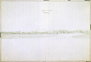
                     English:  View of the fort at Mangalor
                     Bahasa Indonesia:  Pemandangan benteng di Mangalor
( |
||||||||||||||||||||||||||
|---|---|---|---|---|---|---|---|---|---|---|---|---|---|---|---|---|---|---|---|---|---|---|---|---|---|---|
| Author |
Nederlands: Isaac de Graaff (landmeter / kaartenmaker)
English: Isaac de Graaff (land surveyor / mapmaker) |
|||||||||||||||||||||||||
| Title |
Nederlands: Gezicht op het fort Mangalor
English: View of the fort at Mangalor
Bahasa Indonesia: Pemandangan benteng di Mangalor |
|||||||||||||||||||||||||
| Description |
Nederlands: Titel catalogus Leupe (NA): Gezicht van 't Fort Mangalor.
Rechts boven: 20. Notities verso: A. A. nr. 20 verso 499f.. Deze kaart betreft een weergave van de situatie in 1678 en is getekend door Isaac de Graaf na 1690, voor de Atlas Amsterdam.English: According to the Leupe catalogue (NA), the original title reads: Gezicht van 't Fort Mangalor.
Top right: 20. Notes on reverse: A. A. nr. 20 verso 499f.. This is a representation of the situation in 1678 and was drawn by Isaac de Graaf after 1690, for the Atlas Amsterdam.Bahasa Indonesia: Menurut katalog Leupe (AN), judul aslinya tertulis: Gezicht van 't Fort Mangalor.
Di kanan atas diberi nomor: 20. Catatan di belakang: A. A. nr. 20 verso 499f.. Ini adalah representasi dari situasi pada tahun 1678 dan digambar oleh Isaac de Graaf setelah tahun 1690 untuk Atlas Amsterdam. |
|||||||||||||||||||||||||
| Date | between 1690 and 1705 | |||||||||||||||||||||||||
| Medium |
Nederlands: ingekleurde tekening op papier
English: coloured drawing on paper
Bahasa Indonesia: gambar berwarna di atas kertas |
|||||||||||||||||||||||||
| Dimensions | height: 71 cm (27.9 in); width: 50 cm (19.6 in) | |||||||||||||||||||||||||
| Collection |
|
|||||||||||||||||||||||||
| Accession number |
NL-HaNA_4.VEL_887 (old number: VEL0887) |
|||||||||||||||||||||||||
| Inscriptions |
Gesight van 't Fort Mangalor
|
|||||||||||||||||||||||||
| Notes |
English: Subjects: survey / view, fortification, flora
Nederlands: Onderwerpen: overzicht / aanzicht, vesting, flora
English: Post: this image is related to a VOC trading post called Mangalore |
|||||||||||||||||||||||||
| Source/Photographer |
|
|||||||||||||||||||||||||
| Permission (Reusing this file) |
|
|||||||||||||||||||||||||

| Object location | | View this and other nearby images on: OpenStreetMap |
|---|
File history
Click on a date/time to view the file as it appeared at that time.
| Date/Time | Thumbnail | Dimensions | User | Comment | |
|---|---|---|---|---|---|
| current | 16:00, 10 June 2014 | | 2,400 × 1,643 (318 KB) | HuskyBot (talk | contribs) | == {{int:filedesc}} == {{Artwork |title = {{nl|1=Gezicht op het fort Mangalor}} {{en|1=View of the fort at Mangalor}} |description = {{nl|1=Titel catalogus Leupe (NA): ''Gezicht van 't Fort Mangalor''. Rechts... |
You cannot overwrite this file.
File usage on Commons
The following page uses this file:
File usage on other wikis
The following other wikis use this file:
- Usage on nl.wikipedia.org