File:AMH-7063-KB Map of the Hangwelle fort..jpg
Jump to navigation
Jump to search
Size of this preview: 694 × 600 pixels. Other resolutions: 278 × 240 pixels | 556 × 480 pixels | 889 × 768 pixels | 1,185 × 1,024 pixels | 2,400 × 2,074 pixels.
Original file (2,400 × 2,074 pixels, file size: 1.51 MB, MIME type: image/jpeg)
Captions
Captions
Add a one-line explanation of what this file represents
Summary[edit]
Nederlands: Plattegrond van fort Hangwelle
English: Map of the Hangwelle fort.( |
|||||||||||||||||||||
|---|---|---|---|---|---|---|---|---|---|---|---|---|---|---|---|---|---|---|---|---|---|
| Author |
Nederlands: Johann Wolfgang Heydt (tekenaar en graveur), Johann Carl Tetschner (uitgever)
English: Johann Wolfgang Heydt (draughtsman and engraver), Johann Carl Tetschner (publisher) |
||||||||||||||||||||
| Title |
Nederlands: Plattegrond van fort Hangwelle
English: Map of the Hangwelle fort. |
||||||||||||||||||||
| Description |
Nederlands: Plattegrond van fort Hangwelle.
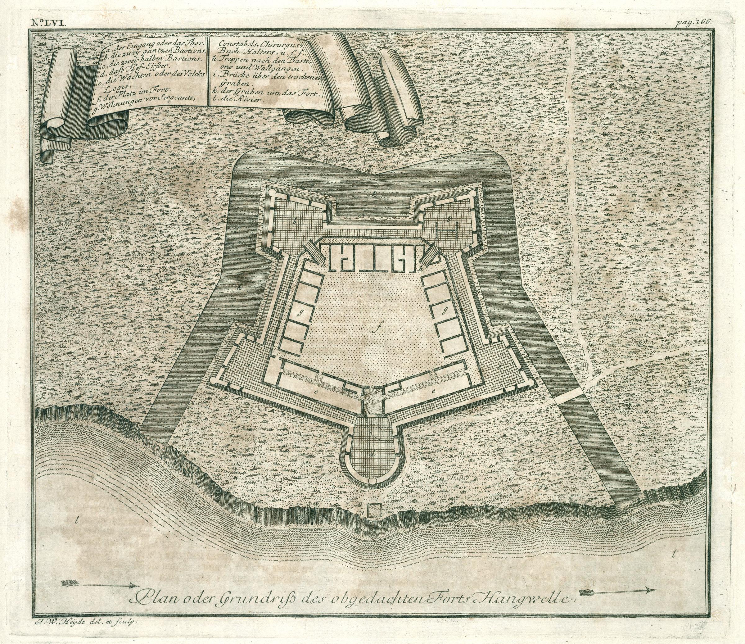
Plan oder Grundriß des obgedachten Forts Hangwelle. Linksboven: No: LVI. Rechtsboven: pag. 166. Legenda: a. der Eingang oder das Thor. / b. die zwey gantzen Bastions. / c. die zwey halben Bastions. / d. daß Hef-Eijsßer. / e. die Wachten oder des Volcks Logis. / f. der Platz im Fort. / g. Wohnungen vor Sergeants., Constabels, Chirurgus, Buch-Halters, u.s.f. / h. Treppen nach den Bastions und Wallgängen. / i. Brücke über den trockenen Graben. / k. der Graben um das Fort. / l. die Rivier.English: Map of the Hangwelle fort.
Plan oder Grundriß des obgedachten Forts Hangwelle. Top left: No: LVI. Top right: pag. 166. Key: a. der Eingang oder das Thor. / b. die zwey gantzen Bastions. / c. die zwey halben Bastions. / d. daß Hef-Eijsßer. / e. die Wachten oder des Volcks Logis. / f. der Platz im Fort. / g. Wohnungen vor Sergeants., Constabels, Chirurgus, Buch-Halters, u.s.f. / h. Treppen nach den Bastions und Wallgängen. / i. Brücke über den trockenen Graben. / k. der Graben um das Fort. / l. die Rivier. |
||||||||||||||||||||
| Date | between 1735 and 1744 | ||||||||||||||||||||
| Medium |
Nederlands: koperdruk op papier
English: copperplate printing on paper |
||||||||||||||||||||
| Dimensions | height: 29 cm (11.4 in); width: 24.5 cm (9.6 in) | ||||||||||||||||||||
| Collection |
|
||||||||||||||||||||
| Accession number |
2102 A 7, p. 166 |
||||||||||||||||||||
| Inscriptions |
Plan oder Grundriß des obgedachten Forts Hangwelle
author: J.W. Heijdt del. et sculp. |
||||||||||||||||||||
| Notes |
English: Subjects: chart / map / plan, banderole / cartouche / ornamentation, key, fortification, building
Nederlands: Onderwerpen: plattegrond / kaart, banderol / cartouche / versiering, legenda, vesting, gebouw
English: Post: this image is related to a VOC trading post called Hanwella |
||||||||||||||||||||
| Source/Photographer |
|
||||||||||||||||||||
| Permission (Reusing this file) |
|
||||||||||||||||||||

| Object location | | View this and other nearby images on: OpenStreetMap |
|---|
File history
Click on a date/time to view the file as it appeared at that time.
| Date/Time | Thumbnail | Dimensions | User | Comment | |
|---|---|---|---|---|---|
| current | 12:21, 10 June 2014 | | 2,400 × 2,074 (1.51 MB) | HuskyBot (talk | contribs) | == {{int:filedesc}} == {{Artwork |title = {{nl|1=Plattegrond van fort Hangwelle}} {{en|1=Map of the Hangwelle fort.}} |description = {{nl|1=Plattegrond van fort Hangwelle. ''Plan oder Grundriß des obgedachten... |
You cannot overwrite this file.
File usage on Commons
The following page uses this file: